Colorado
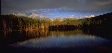
Rocky Mountain National Park - photo by US National Park Service
 Colorado
On March 14, 2010 the Eastern Native Tree
Society and Western Native Tree Society switched from discussion lists
on Google Groups to a new discussion list in a Bulletin Board format at:
http://www.ents-bbs.org/index.php Posts made since the inception
of the BBS on March 14, 2010 will be sorted and archived on the BBS.
Click on the link to go to the equivalent section on the new BBS. This
website will continue to serve as a front end for the ENTS and WNTS
groups. It will continue to serve as a repository of older posts, and
will serve as the host site for special projects and features that are
not well suited for a BBS format. Please visit the BBS for the latest
information and trip reports.
Trip Reports and Discussions
-
-
Meet the Bragg Spruce and the Galehouse Pine
December 20, 2009
-
Pike National Forest (WNTS Colorado Trip Report)
WNTS/ENTS- I'm attaching a report of a recent visit to
the Pike National Forest, hopefully of interest to forum members. I'm of
course happy to expand on visit, should there be questions. I'd also
like to take a second or two and encourage other WNTS/ENTS members to
report of recent or past visits to the forested environments of the
Western US!.. Nov. 13, 2009
-
Narraguinnep Canyon, CO Oct. 27, 2009
Laura, It is interesting that some patches were spared.
I am sure you have thought of many ways to look at the question already.
Whenever someone brings up a research project of this nature. I
immediately start to think of how I would approach the problem. This is
what comes to mind for me. The first step would be to map the areas that
were burned and what were not burned. Maybe from aerial photos? These
could be compared to topographic maps of the area to see if there was
any obvious pattern to the why some areas survived and others did not.
Are they shielded by canyon walls or bluffs so that wind from one
direction would push the fire away from these areas? Lee Frelich has
noted in fire in the Boundary Waters area of Minnesota that fires can
jump across lakes that are a couple miles or more across. So while a
physical barrier might play a role, it may not be the primary cause for
patches to be left. The second step would be to visit these areas and
see if they are different qualitatively fro the areas that burned. Are
these areas actually unburned, or has the understory burned, but the
larger trees survived? What is the density of the understory and
overstory wood in these areas? Is it as far as can be remembered
different from that which was found in the areas that did burn? Are the
unburned areas ones that are wetter than the areas that burned? I can't
think of any good reason why any of the underlying geology would have an
effect. If the pockets survived because of variations of the wind
direction, this is something that you can't go back in time and examine.
I also wonder of there might be any measurable difference in fire
frequency in the areas in which the trees survived and in the areas
where they did not. I would expect if the burn pattern was patchy by
chance there would be fires in some areas that did not occur in others,
but that if the record was long enough that the average frequency would
be similar. I wish I knew more about this type of research
investigation, but even from a layman's perspective it is an intriguing
subject....
more »
-
-
Fossil Redwood September 8, 2009
-
Durango CO
Event July 2010?
-
Eastern and Western Summits July 28, 2009

- The San
Juans, La Platas and back East July 21, 2009
- Western Trip 2009 - Bob Leverett and Monica Leverett
-
Durango, CO
June 11, 2009
- Durango - getting to
know the neighborhood, CO June 11, 2009
- Great Sand Dunes
National Park and Preserve, CO June 12, 2009
- Hermosa Creek Ponderosas
and Doug Firs, CO June 13, 2009
- Coal Bank
Pass, CO June 14, 2009
- Second Visit to
Hermosa Creek, CO June 14, 2009
- Ponderosa
Crazy, CO June 15, 2009
- Raider Ridge, CO
June 15, 2009
- Colorado Trail -
A few more yards June 16, 2009
- Jones Creek - La
Platas, CO June 17, 2009
- Fall Creek Meadow, CO
JUNE 18, 2009
- Pagosa Springs excursion
, CO June 18, 2009
- New Record Blue
Spruce, CO June 20, 2009
- Pigeon Peak and
the West Needles, CO June 21, 2009
- Pinyon Ridge , CO
June 22, 2009
- Naming of names June
21, 2009
- Lees Tree CO June 22,
2009
-
Another
Durango to Silverton Image CO June 23, 2009
-
Pinyon Pine on Chimney Rock, CO June 24, 2008
-
Vista from
Chimney Rock CO June 24, 2009
-
Joint Forest Service
- ENTS outing June 24, 2009
-
Another Western Pics
June 26, 2009
-
Two Champions June 26,
2009
-
Coal
Bank Pass Tree Treasures, CO June 27, 2009
- Tree maximums
at high altitude June 27, 2009
-
Up the Animas River
Valley, CO June 28, 2009
-
Falls Creek Images,
CO June 29, 2009
- Elbert Creek, CO June
29, 2009
- La Platas, CO June 30,
2009
-
La Platas, CO
July 1
2009
-
HD Mountains and the Piedra
River Canyon, CO July 2, 2009
- Cathy Crum's Fremont
Cottonwoods July 2, 2009
-
Jennifer Dudley
Tree, CO July 3, 2009
-
Durango CO Report
July 3, 2009
-
Great Sand
Dunes National Park, CO July 07, 2009
-
Great Sand Dunes
NP, CO July 12, 2009
-
Near Wolf Creek
Pass, CO July 13, 2009
- Piedra River and
HDs July 18, 2009
-
Western Expanses
July 17, 2009
-
Tree records
and Dedications July 13, 2009
-
Southeastern Colorado 2008 July 3, 2009
-
Dune Adventures CO July 20, 2009
Sawatch
Mountains- Roof of the Rockies - Bob Leverett's Mountain Meccas
March 2008
 Rocky Mountain National
Park http://www.nps.gov/romo/index.htm
Rocky Mountain National Park is a living showcase of the grandeur of the Rocky Mountains. With elevations ranging from 8,000 feet in the wet, grassy valleys to 14,259 feet at the weather-ravaged top of Long's Peak. 150 lakes and 450 miles of streams are the basis of the riparian (wetland) ecosystem in the park. Lush plant life and dense wildlife are the hallmarks of these wet areas that speckle and divide other ecosystems. Forests of pine and grassy hillsides dominate the montane ecosystem in the park. These areas may be drier than riparian areas but life still abounds. Look for critters leaping or creeping from tree to tree or poking their heads from underground. As you gain elevation, you leave the montane areas and enter the subalpine ecosystem. The bent and gnarled bodies of spruce and fir trees tell the story of hard summers and harder winters near the mountain tops.
Rocky Mountain National
Park http://www.nps.gov/romo/index.htm
Rocky Mountain National Park is a living showcase of the grandeur of the Rocky Mountains. With elevations ranging from 8,000 feet in the wet, grassy valleys to 14,259 feet at the weather-ravaged top of Long's Peak. 150 lakes and 450 miles of streams are the basis of the riparian (wetland) ecosystem in the park. Lush plant life and dense wildlife are the hallmarks of these wet areas that speckle and divide other ecosystems. Forests of pine and grassy hillsides dominate the montane ecosystem in the park. These areas may be drier than riparian areas but life still abounds. Look for critters leaping or creeping from tree to tree or poking their heads from underground. As you gain elevation, you leave the montane areas and enter the subalpine ecosystem. The bent and gnarled bodies of spruce and fir trees tell the story of hard summers and harder winters near the mountain tops.
Colorado Wild Homepage http://www.coloradowild.org/
Colorado Wild's Forest Watch Campaign works to protect old growth forest, sensitive wildlife habitat, and other sensitive areas in Colorado's forested high country. We simultaneously work to steer fuels reduction efforts towards areas near homes where they are most effective. Through comprehensive monitoring, public education, and application of sound scientific principles, we work to stop ineffective fuels reduction and unfounded logging disguised as “forest health” projects. We promote sustainable forest thinning in these areas that not only protects homes, but provides quality local jobs.
Colorado Tree
Coalition's Champion Tree Registry http://www.coloradotrees.org/champions/
The Colorado Tree Coalition (CTC) Champion Tree Program maintains records of the largest trees in the state. Each year we accept nominations from rural and urban areas all over the state.
GORP - Colorado
Wilderness http://gorp.away.com/gorp/resource/us_wilderness_area/co.htm Beaver Creek, Beyers Peak, Black Ridge Canyon, Buffalo Peaks, Bull Canyon, Willow Creek and Skull Creek, Cache La Poudre, Collegiate Peaks, Comanche Peak, Cross Mountain, Diamond Breaks, Dolores River Canyon, Eagles Nest, Flat Tops, Fossil Ridge, Greenhorn Mountains, Holy Cross, Hunter-Fryingpan, Indian Peaks, Irish Canyon, La Garita,
Lizard Head, Lost Creek, Maroon Bells - Snowmass, Mount Evans, Mt. Massive, Mount Massive, Mt. Sneffels, Mt. Zirkel, Neota, Never Summer Mountains, Powderhorn, Ptarmigan Peak, Raggeds, Rawah, Sangre De Cristo, Sarvis Creek, South San Jaun, Uncompaghre, Vasquez Peak,
Weminuche, West Elk.
|