|
ENTS, WNTS,
Here are m ore photos from yesterday's record breaking trip up La
Plata Canyon to Kennebec Pass. I would like to point out that La
Plata Canyon, up which we drove, is a marvelously wooded mountain
gorge. Its depth by common methods of measurement and comparison is
between 3,000 and 3,500 feet - not so deep as the Animas River
Gorge, but for me, equally scenic. Along the way, I measured a
couple dozen Englemann spruce to heights of between 100 and 110 feet
- enough to satisfy myself that trees in that height class are
common along La Plata Creek up to an altitude of 11,000 feet - in
protected areas. However, there are populations of taller Englemann
spruces in the gorge, but their relative frequency would be
difficult to determine. I'm not going to be able to do it on this
trip. Somewhere in the gorge there is Englemann growing that we will
confirm to over 140 feet. My present belief is that is near the
maximum height that the species will achieve in the gorge and it
will do that only near the water and deep within the gorge.
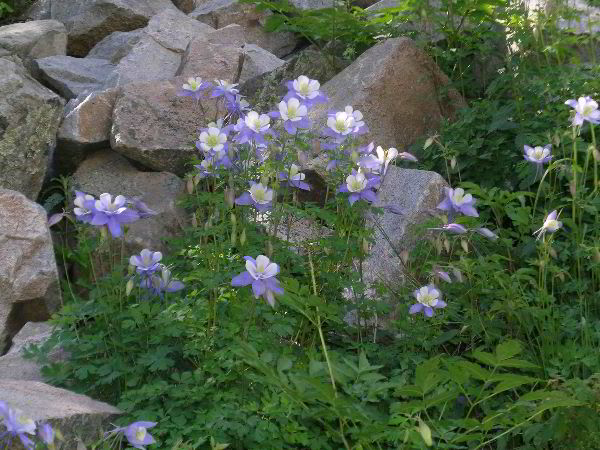
The first image is obviously that of Rocky Mountain columbine. It
was too early to see it in profusion in the upper elevations, where
it becomes a carpet flower. Maybe next year.
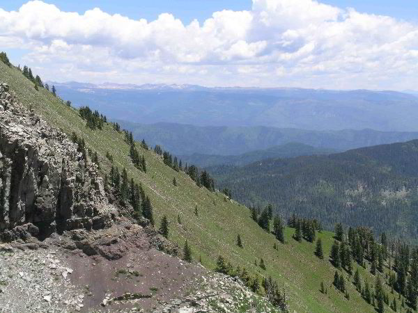
The second image looks to the northeast and into the West Needle and
Needle subranges of the San Juans. To the right, the big peaks
include Elous at 14,083 feet and probably Windom and Sunshine, two
other fourteeners in the Needles.
The 3rd image is of Cumberland Basin, directly beneath us. The
4-wheel drive road to near Kennebeck Pass visible in the basin is
the one we drove. Faye Schrater expertly drove the road and made the
experience a complete pleasure.
Full report on today's activities this evening.
Bob
Gary,
I used Monica's Nikon Coolpicx5400.
Attached for your viewing pleasure are three more images of
yesterdaay's La Plata adventure. The first image is from above the
Cumberland Basin area, a big bowl-shaped depression just below
timberline. Cumberland Basin is the origin of the La Plata River.
The big ridge in the foreground is the summit of 12,388-foot
Cumberland mountain. You can see one remaining patch of snow. Our
path took us up onto the side of Cumberland Mountain. The second
image looks down into Cumberland Basin. The ridge in the foreground
is part of Snowstorm Peak. The third image is from the pass between
Cumberland Mountain and 12-511-foot Snowstorm Peak. According to my
GPS our elevation was 11,956 feet at the point of the photo.
According to the topographical map, our elevation was 12,000 feet.
The long line of peaks in the distance are the San Juans near
Silverton.
Bob
----- Original Message -----
From: "Gary A. Beluzo" <garybel ...@me.com>
To: entstrees@googlegroups.com
Sent: Wednesday, July 1, 2009 8:30:46 PM GMT -05:00 US/Canada
Eastern
Subject: [ENTS] Re: La Platas
Bob,
What kind of camera did you use to get these beautiful shots?
Gary
On Jul 1, 2009, at 10:07 AM, dbhg...@comcast.net
wrote:
ENTS, WNTS,
Here are more photos from yesterday's record breaking trip up
La Plata Canyon to Kennebec Pass. I would like to point out that
La Plata Canyon, up which we drove, is a marvelously wooded
mountain gorge. Its depth by common methods of measurement and
comparison is between 3,000 and 3,500 feet - not so deep as the
Animas River Gorge, but for me, equally scenic. Along the way, I
measured a couple dozen Englemann spruce to heights of between
100 and 110 feet - enough to satisfy myself that trees in that
height class are common along La Plata Creek up to an altitude
of 11,000 feet - in protected areas. However, there are
populations of taller Englemann spruces in the gorge, but their
relative frequency would be difficult to determine. I'm not
going to be able to do it on this trip. Somewhere in the gorge
there is Englemann growing that we will confirm to over 140
feet. My present belief is that is near the maximum height that
the species will achieve in the gorge and it will do that only
near the water and deep within the gorge.
The first image is obviously that of Rocky Mountain columbine.
It was too early to see it in profusion in the upper elevations,
where it becomes a carpet flower. Maybe next year.
The second image looks to the northeast and into the West Needle
and Needle subranges of the San Juans. To the right, the big
peaks include Elous at 14,083 feet and probably Windom and
Sunshine, two other fourteeners in the Needles.
The 3rd image is of Cumberland Basin, directly beneath us. The
4-wheel drive road to near Kennebeck Pass visible in the basin
is the one we drove. Faye Schrater expertly drove the road and
made the experience a complete pleasure.
Full report on today's activities this evening.
Bob
<Columbine.jpg> <LaPlataSmall6539.jpg> <LaPlataSmall6542.jpg>
Continued
at:
|