| Hurricane
Isabel, September 2003 |
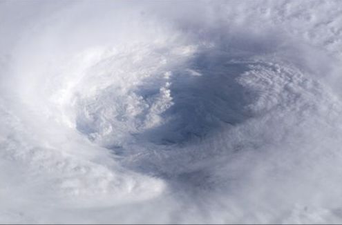
Astronaut Ed Lu snapped this photo of the eye of Hurricane Isabel from the International Space Station on September 13, 2003 at 11:18 UTC. At the time, Isabel was located about 450 miles northeast of Puerto Rico. It had dropped to a Category 4 hurricane on the Saffir-Simpson Hurricane Scale, packing winds of 150 miles per hour with gusts up to 184 miles per hour.
After originating in the eastern Atlantic west of the Cape Verde Islands, Isabel became the second major hurricane of the 2003 Atlantic season when it was declared a Category 3 storm by the National Hurricane Center on September 8. Over the next four days, Isabel strengthened into an extremely powerful Category 5 hurricane with winds estimated at 160 mph before dropping to a Category 4 hurricane on September 13.
This photo shows the structure of Isabel's eyewall. The image, ISS007-E-14745, was taken with a 180mm lens on a digital camera.
Image courtesy of Mike Trenchard, Earth Sciences & Image Analysis Laboratory , Johnson Space Center.
Although she had subsided from a Category 5 to a Category 2 storm, Hurricane Isabel still packed considerable punch as she came ashore between Cape Lookout and Cape Hatteras on North Carolina’s Outer Banks on September 18, 2003. Isabel grew to a massive size just before she hit land, with hurricane-force winds radiating as far as 185 km (115 miles) from the eye, and tropical storm-force winds extending roughly 555 km (345 miles) outward from the eye.
The still image above, and the accompanying time series, was acquired by the GOES satellite at 2:02 PM EDT, September 18, 2003. The movie begins as Hurricane Isabel was approaching Cape Lookout on the morning of September 18. As the eye of the storm moved inland, Isabel veered to the north and weakened into a tropical storm, losing much of its structure. The storm charged up the western side of the Chesapeake Bay and continued on its northward surge until it eventually fell apart over Ohio.
With its relatively high winds and heavy rains, Isabel pounded heavily populated areas in North Carolina, Virginia, Washington, D.C., Maryland, and Delaware, claiming at least 35 lives and leaving millions without power. Due to the widespread damage caused by the storm, President Bush declared major disaster areas in each of those states.
| Hurricane
Isabel |
Robert
Leverett |
| Sep
15, 2003 10:01 PDT |
Dale:
A big hurricane hitting the Northeast will most likely change
some
Rucker indexes. Perish the thought, but it could happen. We all
live
with that threat. Small places are exceptionally vulnerable. As
much as
I worry, I am also somewhat excited about the test of
survivability of
different kinds of forests and forest structures.
In a way, all this is old hat to Lee on Minnesota. He lives with
the
threat of big weather events that go almost unnoticed and
unreported by
the self-important eastern seaboard.
Bob
|
| RE:
Isabel |
NR,
Cook Forest Env. Ed. |
| Sep
19, 2003 12:48 PDT |
ENTS,
'Tropical Storm' Isabel caused no major problems at Cook Forest
(power outages, phone lines down, roads closed, etc.). I'm not
sure of the current Rucker status, but all we really got here
was some heavy drizzle and an occasional gust to maybe 30mph...
nothing more than a regular blustery day.
Dale
|
| Re:
Hurricane Isabel |
Colby
Rucker |
|
Sep
24, 2003 12:54 PDT |
Dale,
After six days without power, I'll rejoin the civilized world,
on a rather
selective basis, as before. I'm glad to hear that Isabel treated
CFSP
rather gently. Locally, the high tides in Annapolis were the
national news,
and the highest I've seen. We were fortunate to escape
torrential rains,
but the winds were strong, from the northeast, and leveled trees
all over.
I've seen at least 25 fair-sized trees down in my woods,
damaging numerous
smaller trees. In addition, half a dozen black cherries went
down closer to
the house, providing some welcome firewood from an otherwise
nuisance
species ranked # 59 out of 65 on my list.
The rather uniform intensity of the winds was in contrast to the
violent
gusts of Hurricane Floyd several years ago, which took down a
swath of white
oaks and other sturdier trees. I found the results from Isabel
quite
interesting, suggesting several factors which seem to support my
contention
that the original forest was lower, competing more by spread
than by height.
Trees uprooted were primarily tuliptree, chestnut oak, and red
maple.
Diameters were mostly 16"-32". It appeared that more
slender specimens
survived by having low sail area, and less trunk weight to
contribute to
momentum. Larger trees with a well-developed
crown survived, although
having a greater sail area. Although heights ranged up to 140',
it appeared
that a big crown is essential to provide sufficient nutrients
for a
well-developed root system.
Most woodlands are logged long before this transitional stage is
reached.
In one instance, tall chestnut oaks apparently
"sheltered" by a large
tuliptree were blown down, while those to either side escaped.
The
tuliptree had forced the oaks into a race for height which they
could not
win. Their resources went into height development, which
resulted in tall
handsome stems. Once the stems were heavy enough, there was
sufficient mass
for windthrow. A small crown and being on the lee side of the
poplar gave
little protection once the limited root system was overwhelmed
by sufficient
trunk mass.
Chestnut oaks to either side had less tuliptree competition, and
were
shorter, with more divergent crowns producing more nutrients,
with enough
excess to stimulate greater root development. Another large
tuliptree did
essentially the same thing. Some weeks ago I thought the more
slender
competitors would progressively shade, and therefore reduce, the
lower
portions of the tuliptree's crown, but there is danger to the
more slender
competitor, and the big tuliptree now stands alone.
Of course, the chestnut oaks made a second mistake by venturing
into areas
characterized by tuliptree, pawpaw, red maple, northern red oak,
etc.
Although the form and height of such specimens is noteworthy,
they cannot be
windfirm in such habitat. The same can be said of scarlet oaks,
with the
tallest specimens being found at the more fertile fringes of
their typical
habitat. Most of the chestnut oaks blown down were in low-slope
positions,
where they grew quite happily for a hundred years, but had, we
see, ventured
beyond their more permanent habitat.
The red maples uprooted were part of a continuing trend which
suggests that
they, despite their shade tolerance, are of earlier succession
than most
mature woodlands would suggest. Although losses of various
species opened
up the canopy, the canopy is more likely to be filled by nearby
trees
increasing their spread, rather than vertical growth by new or
small
specimens. This process is different, and more interesting, than
that
following Hurricane Floyd.
Colby
|
| Re:
Hurricane Isabel |
Fores-@aol.com |
| Sep
25, 2003 16:08 PDT |
Colby:
What you described as an impact of Hurricane Isabel sounds very
similar to
the damage we experienced during an ice storm on our steeply
sloping land in WV.
The tree species we lost the most of shared the physical
properties that you
mentioned. Many of the largest and most vigorous trees saw their
tops
partially broken or shredded but the surrounding skinny
interlopers were often nuked,
flat or shattered.
Excellent observations.
Russ Richardson |
| RE:
Hurricane Isabel |
Dale
J. Luthringer |
| Sep
26, 2003 20:40 PDT |
Colby,
Glad to hear you're back in civilization, although you may not
welcome
the plague of multiple e-mails in your box. 6-days?! That would
give
me a good excuse to finish up last year's venison before it went
bad!
Hope your house didn't suffer any damage.
I know some would consider this next question a rub on your age,
but who
else can we go to for such sage advice? How did Hurricane Floyd
compare
to Hurricane Agnes in your area in 1972? Our retired park
manager
remembers Agnes well. I'm not sure about the extent of downed
trees
back then, but the Clarion River made the Park Office into an
island and
put about 8ft of water in its basement.
Those "nuisance" black cherries sure do burn pretty
though, along with
that nice 'snap, crackle, and pop' sound.
Dale
|
| Re:
Hurricane Isabel |
Colby
Rucker |
| Sep
26, 2003 23:39 PDT |
Dale,
As we get older, our experience is punctuated by various events,
and
hurricanes seem to top the list, being a convenient source of
conversation
in a given area. Locally, storms in 1933, 1954, 1955, 1972,
1979, 1999,
and 2003 affected Anne Arundel County.
The 1933 storm was before my time, but it came right up the
Chesapeake Bay,
and caused severe wind damage, beach erosion and coastal
flooding. Hazel,
in 1954, was a massive storm that passed over this area, causing
widespread
wind damage, including breakage to the Liberty Tree and other
big trees.
Chainsaws were almost non-existent, but no one was in much of a
hurry, and
cleanup was done as convenient, sometimes months later. Rainfall
was
considerable, but coastal flooding was modest. Connie, in 1955,
was less
damaging, but caused higher levels at tidewater.
Agnes, in 1972, caused little if any wind damage, but brought
rains of ten
inches or more. The most severe flooding was in Pennsylvania,
but local
streams of even modest size became torrents, eroding their
banks, and
causing dramatic blockages of uprooted trees and all sorts of
debris. The
county boundaries along the Patuxent River, Deep Run, and the
Patapsco River
were the scene of much destruction, with many homes and
businesses
destroyed, and the bay was covered with all sorts of logs and
debris swept
down the Susquehanna. I had several stream-clearance contracts
with the
Corps of Engineers, but trees on most private properties were
unscathed.
David, in 1979, caused considerable wind damage to trees at
estates along
the western shore of the bay, but little inland. Floyd, in 1999,
was a big
storm, with strong winds, but most damage came from sudden gusts
of
scattered occurrence. The Liberty Tree evidenced a split near
the 1954
injury, but 45 years had changed our society to one menaced by
lawsuits and
lawyers, and the tree, still vigorous, was removed after being
deemed unsafe
by five tree experts and the college, all eager to avoid any
legal
responsibility.
Isabel was a strong storm, but the winds were of rather uniform
intensity.
Its path pushed water up the bay and to the western shore,
causing coastal
flooding not equalled since 1933. Tree breakage was rare, but a
wet season
induced much windthrow, which caused problems in a landscape
much more
intensely developed than before.
About 95% of the county lost power. Outages (six days here) were
more
prolonged than even Hurricane Hazel. Baltimore Gas and Electric
had lost
hundreds of millions in an ill-fated bid to wheel and deal
energy on a
national basis, and had cut customer service to make up for it.
They had
consolidated their crew locations, and closed local yards. They
had been
telling callers they didn't remove hazardous trees over wires or
transformers, or even remove trees that had fallen on their
wires. They'd
ask if the wires were sparking, and tell the caller to contact
someone else,
perhaps the county, to no avail. They actually were still
contracting tree
work, but had cancelled their contract with Asplundh, and used
tree trimmers
from Pennsylvania, who worked four days a week.
Without Asplundh, there were no local crews, and it took days to
get help in
from Ohio and other areas. Without a large resident workforce of
Asplundh
workers (who did private work quite reasonably on weekends)
private tree
outfits have a near monopoly, and their prices are predatory.
Such is the
case in a more anonymous society, with little interest in one's
reputation.
Everyone seems in a hurry, and county crews, replete with lots
of heavy
equipment, are busy everywhere cleaning up in the land of tax
hell.
So, each hurricane was different, not only the storm itself, but
also in its
effect, due to continuing changes in our society.
Colby |
| RE:
Hurricane Isabel |
NR,
Cook Forest Env. Ed. |
| Sep
27, 2003 11:43 PDT |
Colby,
Thanks for the account of these past hurricanes. Let's see,
that's almost 50's years of a living history lesson!
PA received close to 10" of rain from Agnes. We have not
observed flooding on the Clarion to those flow levels since
then. Our worst flood event was during the same storm that
created the "Johnstown Flood" on 3/17/36. Flood stage
at the Park Office is at 13ft. The Johnstown Flood storm
resulted in a river depth of 19ft at the Cooksburg Bridge with a
flow of 56,000ft^3/sec. A normal summer depth at this gauge
would be from 2-3ft and flow of 600-800ft^3/sec.
We received some rain from Floyd in 1999, but nothing compared
to Philly who got 6.63". Cook Forest did experience a heavy
rain event 7/18/98 with close to 6" of rain in a 24hr
period. Flash flooding stripped away bridges, vehicles, roads,
and houses. It took them about 3 years to replace all the
bridges that were washed away on the side roads.
2003 has been one of the wettest years on record since my tenure
at Cook Forest. The saturated soils and recent microbursts have
opened up many areas of the canopy in our old growth sites. The
Forest Cathedral area is much more opened up now than it was 7
years ago. This would be a great opportunity for quicker
regeneration if we could get a handle on the high deer density.
Dale
|
|