ENTS:
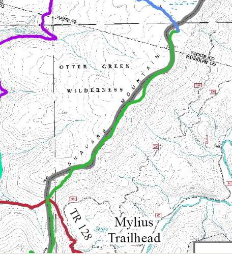
This past October I had a chance to visit an old growth stand of
Spruce/Hemlock. The stand is located on Shavers Mountain on the
Cheat/
Potomac Ranger District of the Monongahela National Forest. The
crest
of Shavers Mountain in this area forms the eastern boundary of
the
20,000 acre Otter Creek Wilderness area that was designated as
such in
1975. Check out this link:
http://www.fs.fed.us/r9/mnf/sp/ottercreek.html
The Southern end of Shavers Mountain also contains the old
growth
Spruce site at the Gaudineer Scenic Area.

It takes a bit of hike to get to the Shavers Mountain stand. The
shortest hike is from the Mylius trailhead along Glady Fork on
the
east side and several miles north of US 33 East of Elkins, WV.
From
the trailhead it is a 1.7 and mile and +800 feet hike to the
saddle
between Glady Fork and Otter Creek then another 2.0 miles and +
600
feet along the Shavers Mountain trail. The stand is right along
the
trail and after surveying the Rhododendron my hiking companions
thought they might continue on the trail and check out the
bog/fen
further out the trail and leave me to enjoy my questionable
pursuit of
measuring trees. I spent about 3 hours and got pretty accurate
measurements on about twenty trees most of them using the ENTS
Sine
method with a laser and clinometer. I could have used an
assistant
with a pole to plumb the dept of the Rhody. However a heavy wet
snow
(12”) that fell a couple of days previously had beat down the
Rhododendron a lot and a hard crust had formed on top and I was
able
to walk on top for substantial distances before crashing
through.
Every time I did crash through I thought of all the bear tracks
and
scat we had seen while hiking up the trail and wondered who I
was
disturbing.
Here are the largest
Red Spruce/P.rubens- 4.6’ and 88.0’
6.3’ and
74.3’ with top out
Eastern Hemlock/T. Canadensis- 6.8’ and 80.9’
10.1’ and
78.1’ with top out
Red Maple/A. rubrum 7.7’ and 79.6’
Black Cherry/P. serotina 6.9’ and 76.7’
Yellow Birch/ B.alleghaniensis 7.3’ and 67.6’
For a 5 species Rucker index of 78.6’ br>
The acreage of this stand has variously been described between
50 and
100 acres. I may have covered 5 acres at the most. We did this
for a
day hike but next time it will be an overnighter so I can get
over
more of the stand.
Supposedly there is another old growth stand on the west side
along
Turkey Run.
I did not take any pictures but check these out in the following
link:
http://exploro-orbis-terrarum.smugmug.com/gallery/3781365_t5u6y/1/217928115
Also Jonathan Jessup does a lot of hiking and shoots lots of
photos in
the area. His work should be easy to find on the internet.
Also good news – saw no signs of HWA
Bad news- Beech has been wiped out along Shavers Mountain
trail in this section
TTurner Sharp