|
==============================================================================
TOPIC: Shenandoah National Park
http://groups.google.com/group/entstrees/browse_thread/thread/b55b8716e1dbeb16?hl=en
==============================================================================
== 1 of 2 ==
Date: Wed, Mar 26 2008 4:02 pm
From: "Edward Frank"
ENTS,
With many people going to western North Carolina in a few weeks, I
thought I would revisit a trip to Shenandoah National Park and
environs from a couple years ago.
Ed Frank
Shenandoah National Park, VA, July 2005
July 05, 2005 The day started and ended with the sound of thunder. I
awakened at around 6:30 to the sound of rolling thunder through my
drapes. It was my last night for a long time in my own bed, but I
did not sleep well from the anticipation of my southward journey.
After a a few delays I got up and packed the last items for my trip
- razor, tooth brush, alarm clock. The I was off, I headed down 219.
219 runs south and is a mixture of small windy back roads to
four-lane thoroughfares. I opted to not stop at any of the familiar
parks along the way - the Portage Railroad National Historic Site,
nor the Johnstown Flood National Memorial, but to head on down to
Maryland. These were familiar paths for me as I went on caving trips
and visited the sites in West Virginia and western Virginia many
times in the past. Just after entering Maryland I headed east on
68/40.
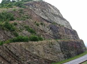
The first stop was Sideling Hill Exhibit Center. http://www.mgs.md.gov/esic/brochures/sideling.html
The Exhibit Center is located beside a deep road cut slicing through
the axis of of a sharply folded syncline. I stopped on the south
side of the east-west parkway. From here it is a short walk up to a
pedestrian overpass. The best view of the syncline is from the south
end of the overpass looking to the north side of the fold. The
overpass leads to a three story exhibit center on the north side of
the road. In the exhibit center are many displays explaining the
geology of the area and information on the nearby wildlife area.
Also on the north side is a viewing platform atop a series of
stairs. The view from the platform shows you the south face of the
road cut and an oblique view of the north face. It is certainly a
worthwhile stop to stretch your legs. I don't think it is
destination in its own right unless you are going on a geology field
trip. Wikipedia describes the site as follows: "The Sideling
Hill road cut is a 340-foot deep road cut where Interstate 68 cuts
through Sideling Hill, about 6 miles west of Hancock in Washington
County, Maryland. It is notable as an impressive man-made mountain
pass, visible from miles away and is considered one of the best rock
exposures in Maryland and the entire northeastern United States.
Almost 810 feet of strata in a tightly folded syncline are exposed
in this road cut. Although other exposures may surpass Sideling Hill
in either thickness of exposed strata or in quality of geologic
structure, few can equal its combination of both. There is an
Exhibit Center to help provide the public with a better
understanding of the geology of the cut. A pedestrian walkway bridge
crosses I-68 for better access to the cut, along with a picnic area
and rest area facilities." http://www.dnr.state.md.us/publiclands/western/sidelinghill.html
Certainly as the exhibit sits astride an major interstate, this is
one of the most visited state parks in the country. The exhibit sits
on the edge of the Sideling Hill Wildlife Management Area, a
3,000-acres of mixed oak-hickory forest that straddles Sideling Hill
Creek.

Shortly after this I turned south on 522 at Hancock,Maryland toward
Winchester VA http://en.wikipedia.org/wiki/Winchester
_Virginia A
beautiful doe with a couple of fawns were grazing across a small
swampy pond just to the side of the interstate. 522 first passes
into West Virginia just a few miles from Berkley Springs. One thing
that really caught my eye were the patches of cheery orange tiger
lilies growing in patches along the road. Winchester is a modest
town in Virginia. There are a series of giant artificial apples
scatter across the town painted with scenes. I believe they have an
annual apple blossom festival. It is a confusing town to drive
through - many one way streets and the routs are not well marked, or
when they are they form a cluster of six or seven signs each
pointing to different routes in different directions. From here to
Front Royal, VA the northern end of Shenandoah National Park.

Just before reaching the park I was driving down the road and
suddenly I saw some large dinosaurs along the road. These concrete
dinosaurs were advertising a roadside attraction called dinosaur
world. I stopped and took a few photos but did not take the tour.
Giant dinosaurs, I just had to stop. I ask the girl at the
convenience store if she had noticed there were dinosaurs outside.
Yes she had. She told me there had been quite a few comments made
when the dinosaurs were last restored and painted bright colors
rather than the gray they had been painted previously. On to
Shenandoah.
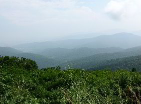
Shenandoah National Park runs along the spine of a ridge running
south-southwest for a distance of about 100 miles. http://www.nps.gov/PWR/customcf/apps/maps/showmap.cfm?alphacode=shen&parkname=Shenandoah%20National%20Park
The road continues southward as the Skyline Drive (including the
park). My first memories of visiting the Skyline Drive was riding in
the car as my father drove along the highway in a dense fog. We
could not see the lines the edge of the road because of the fog
thickness.. I entered the park through the Front Royale entrance at
the north end of the park.

A couple of miles into the park I found some unusual wildflowers
with tall spiky white flowers - black snakeroot- and stopped for a
few pictures. There are large numbers of overlooks along the
highway, averaging over one per mile within the park. These may face
westward or eastward overlooking the valleys below as the road winds
from one side of the narrow ridge to the other. It is interesting to
see how the weather may be sunny on one side of the ridge, while on
the other it may be pouring down rain. I stopped at the Dickey Ridge
Visitor Center, the northernmost park office before heading to the
Matthews Arm Campground. I did not know what to expect so I decided
to set up camp first then go sightseeing. The campground was
sparsely filled, so I picked out a spot and set up my tent. It is a
steep climb up out of the campground and my little Tracker sputter
and spurted and threatened to die. I figured I had to get some gas
treatment before I returned if I wanted to make it out again.

Five-fingered tuliptree
Upon reaching Skyline Drive again I headed back northward. A short
distance ahead was someone stopped in the road coming the other
direction. A black bear was foraging along the shoulder of the road.
I grabbed my camcorder and started shooting. I probably got two full
minutes of video before the bear wandered off. I continued northward
stopping at various overlooks for views and still photos. Eventually
I found one with a cell phone signal and called home to tell my
mother I was fine. There were many short hikes listed in a booklet I
bought and there was time to squeeze in a couple before dark. The
first was Lands Run, a 1.3 mile round trip to a small waterfall. The
thing about most hikes in the park is that you are starting off at
the ridge top and going downhill to see something, then the hike
back is all uphill. An unusual tree along the trail was a multistem
clump of tulip tree. Five separate stems grew upward, then ant a
height of 15 feet or so they spread outward like the fingers on your
hand.
The park has a long history of logging. The park website http://www.nps.gov/shen/naturescience/forests.htm
"Surveys in 1940 and the late 1980s show that the forests of
Shenandoah National Park have changed dramatically in 50 years. The
changes include the percentage of forested lands, and the ages,
sizes, and species of trees. In 1940, Shenandoah was a young park.
It was authorized by act of Congress in 1926 and established in
1935. For almost 200 years prior to park establishment people had
harvested and used the resources of these mountains. Timbering,
grazing, hunting, and cultivation ceased when these lands became a
national park. In 1940 the park was 85% forested. The rest of the
park was open ground, including grasslands, cultivated fields, and
old fields reverting to forest. Previously grazed areas were being
occupied by bear oaks and pitch pines. By 1990 the park was 95%
forested. In the more mature forest, bear oak stands had disappeared
and pitch pine numbers had dwindled. In 1940 there were no yellow
poplar stands and cove hardwoods covered only 6% of the area. By
1990, yellow poplar stands covered 16% of the park and cove
hardwoods covered 15%. These forest types grow in moist sites. Their
increase is evidence of more organic matter in the soil and more
adjacent protective forest canopy cover. In 1940 chestnut oaks and
northern red oaks covered 72% of the park. By 1990, their numbers
were down to 59%. Since 1990 repeated defoliation by non-native
gypsy moth caterpillars has contributed to the deaths of even more
oaks."
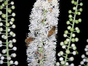
Black Snakeroot Flowers and Bees
The second hike was to Fort Windham Rocks. It was essentially a
level hike that includes a short segment of the Appalachian Trail.
The trail leads to some rock formations that are metamorphosed
basalt called the Catocin Formation. The outcrop is to the right of
the trail with the main mass of the outcrop forming an exposure
40-50 feet high. On the way back to the Geo I experimented with
taking flash pictures of the bees and other insects madly scurrying
among the plentiful black snakeroot flowers along the trail.

It was getting late so I took off southward again. I was going to
hit highway 211 west out from the park to find some food, gas, and
stuff for my car. There were a few sprinkles, but the sun was
shinning. To the east were fantastic rainbows arching across the
sky. By the time I reached 211 it was looking grayer. A buck deer
horns in velvet was browsing along the off ramp. I stopped and took
some still photos. I wanted to get my camcorder, but I was afraid if
I moved, the deer would flee. I headed westward toward Luray. By the
time I got to the valley bottom, there was a massive dire looking
storm brewing. I picked up the supplies in Luray and headed back. As
I drove northward back towards Matthews Arm Campground it rained so
hard that at time I could barely see the road. But I drove slowly
and pushed onward.


When I arrived back at the campsite, I found one of my tent flaps
had come open. Inside my tent were puddles of water. My sleeping
back was sitting atop a plastic covered foam sleeping pad, so it was
not soaked, but still wet in places. My pillow was damp. I tried to
stretch out in the Tracker, but there was little room. The lightning
flashed and thunder rolled. Lightning bugs were fluttering about in
the trees flashing away. I wonder if they were excited by the
lightning strikes? As the rain paused for a brief respite, I decided
to give my tent a try. I soaked up the water on the floor with a big
towel, spread out the sleeping bag to put the wet spots down, and
got a dry blanket from the truck to cover myself. As I lay in the
somewhat damp bed, the rain began to fall. It is neat to listing to
the raindrops strike the tent walls just inches from your head. I
lay for awhile listening to the patter of raindrops, and I fell to
sleep to the sounds of thunder.
July 6, 2005 I had camped out overnight at the Matthews Arm
campground. I awakened just after 6 am to the dampness. The water
from the previous night had soaked through my belongings and myself.
I broke camp and headed out. My Tracker took the climb back out from
the campsite with no complaint, at least the fuel additive worked.
Overall it wasn't a bad morning. The weather fluctuated from cloudy
threatening to rain to bright sunshine depending on where you were
on the road. I headed south. I must have stopped at almost every
overlook on my way to Big Meadows.
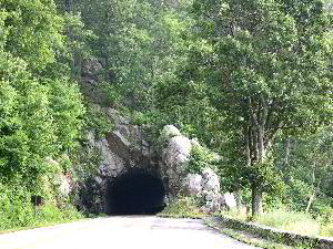
Mary;s Rock Tunnel
There is a 600 foot tunnel through the hill at Mary's Rock built in
1932. The mountain laurel is pretty much past its peak here at the
park, but isolated bushes are still in bloom. One hike I wanted to
try was to Stony Man Peak. At the peak are remnant populations of
balsam fir and red spruce dating from a time when the climate was
much colder here. But the weather looked bad, it was sprinkling on
and off, I decided to try this hike another day. The Appalachian
trail runs from Georgia all the way to Maine. The Trail runs through
the park parallel to skyline drive frequently cross crossing the
highway. Occasional long distance hikers could be spotted as I made
my way southward along the drive. Within the park are almost 500
miles of trail, so anyone looking for a place for hiking, there is
plenty of opportunity in the park.

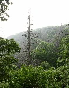
One thing that had caught my attention were the many standing dead
trees in the park. There were both deciduous and conifers. The
conifers were generally hemlocks. In 2005 I wrote the following:
"These great trees had been killed in the past couple seasons
by the Hemlock Wooly Adelgid an invasive pest that arrived in this
country from Japan It has been decimating the hemlock populations
throughout the south. Hemlock occupies a unique niche in the
ecosystem of these forests, I am not sure if there will be anything
that can really replace it if all of the hemlocks die off. This may
be the beginning of a major blight like killed the American Chestnut
earlier in this century. The adelgid does not seem to have been as
effective in the north yet. Whether this is because of the freezing
winters, or just that it hasn't traveled that far. There has been
some success in the south using chemical pesticides to inoculate the
trees and with release of predatory beetles, but these processes are
slow and expensive and cannot practically save the vast tracks of
forest affected by the pest."
In response to my HWA/Hemlock survey the Park Service wrote (2007):
"The forests of Shenandoah National Park occur primarily on
steep rocky slopes. Higher elevation forests of the park are
dominated by chestnut oak, red oak, hickory, and mountain laurel.
Mixed hardwood forests of ash, cherry, basswood, birch, red oak, and
maples cover the mid and lower-slopes, and tulip poplar and spice
bush dominate the lowest slopes and stream valleys. Eastern Hemlock
areas comprise approximately 250 acres (mostly which are currently
being treated with imidacloprid soil injections). Human disturbance
occurred in many park locations prior to 1935. Since then, there has
been very little (e.g. trail maintenance) or no disturbance. The
last old-growth hemlock stands succumbed to the HWA from 1995-2003
(Camp Hoover, Hemlock Springs, and Limberlost - in that order). In
general, the lower elevation hemlock sites (1000'-2000') became
infested and declined quicker than the higher elevation sites
(3000'-4000'). Over the last 11 years, several droughts are believed
to have accelerated HWA-related hemlock mortality throughout the
park (e.g. two droughts between 2000 and 2002 were probable causes
of the previously healthy Limberlost old-growth (high elevation)
stand for having quickly succumbed to the HWA during 2001-2003).
Hemlocks found farther away from park streams have been more
susceptible to drought than ones growing near the stream edge or in
moister areas. The lack of sustained cold winters/springs from
1993-2006 also hastened hemlock decline and mortality in many areas.
Early on, resource managers at Shenandoah weren't sure what the
long-term effects would be. They also didn't know what HWA
treatments worked well in the early 1990s. Our techniques, access,
and budget were limited, and bio-controls weren't realistically
available. In 2006, HWA Suppression took place on 157 acres
throughout the park. Imidacloprid soil injections were made on 97
acres (550 trees). These injections are made every other year. M-PedeR
insecticidal soap was applied on 60 acres (or 510 trees) that were
treated one-two times during the year. in general, hemlock crown
health remained stable in 2006 in treated areas. Moisture conditions
were sufficient throughout the growing season and drought was not a
crown health decline factor." The dead deciduous trees were
generally killed by another introduced invasive pest, the Gypsy
Moth. The gypsy moth is not as selective in its diet and will feed
on almost any species of tree. However it does have some preferences
and the oaks are the hardest hit by the moth caterpillars. Many of
the standing deciduous trees were oaks. There had been some fires in
certain areas of the park, but these dead specimens were not a
result of fire. They were scattered about the hillside among other
healthy trees in areas not affected by fire as marked on the park
service maps. A copy of an article from the parks newsletter
Resource Management Newsletter 21 from 2005 discussing the HWA is
appended at the end of this document.
In the Skyland section of the park, near the horse stables, I had
the opportunity to take some video of a doe and two spotted fawns
feeding next to the road. When first established the park did not
have any whitetail deer living in the park area. They had been
hunted until gone from the area by previous generations. Whitetail
deer were reintroduced in the park in the 1930's after the
establishment of the national park. Today the park supports a good
population of healthy deer. Other animals absent from the area or
rare are now making a comeback. In 1976 the US Congress 40% of the
park as wilderness, partially because of the comeback the vegetation
and wildlife has made since the park's establishment. Most of the
area designated wilderness can only be seen on longer hikes or
through hikes on the Appalachian trail.

Dark Hollow Falls
One short hike I could not pass up was the trail to Dark Hollow
Falls. The sign said a 1.4 mile round trip hike to an 80 foot
waterfall. The weather had cleared so off I went. The entire trip to
the falls is downhill. There is an elevation drop of 440 feet. Soon
I reached to the top of the falls, a small stream tumbling off a
rock ledge. Access to the top of the falls itself is blocked by
fencing, but the path continues down another 0.2 miles to the base
of the falls itself. It had rained so a fair amount of water was
tumbling its way down the cliff side in several stair-steps
segments. Several groups had made their way to the base of the
falls, and some were passed heading back out. This is the closest
waterfall to Skyline drive in the park and was worth the hike down
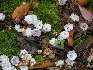
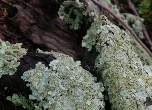
and back out again. Along the trail are the small items that seem to
catch my eye whenever I hike. One log was covered with pale
blue-green foliose lichens. Under a laurel bush was a pile of
mountain laurel flowers lying on the moss. It is these details that
make many of these hikes memorable, not just the major features you
go to see.
Next stop was the laundromat at Big Meadows. I needed to dry out my
sleeping bag, blanket, and pillows. It took awhile but gave me an
opportunity to catch up with my writing. From here I headed south
again stopping at numerous overlooks. At the Blackrock overlook, a
trail leads to a talus slope on the hillside. I stopped at a dozen
more overlooks along the way, but eventually exited the park at
Rockfish Gap and headed east on 64.
The park service website has a couple of unusual sections that I
wanted to mention. The first deals with natural soundscapes: http://www.nps.gov/shen/naturescience/naturalsounds.htm
"Soundscapes are important natural features of national parks.
Besides contributing to the visitor experience they may be
indicative of natural resource conditions. Wildlife may use
particular sounds during courtship and mating or other behaviors
which all make up the acoustic ecology of the area. Sudden sounds
stem from trees or branches falling or when rock slides occur.
Burning leaves and wood give off crackling and hissing sounds.
Natural sounds may also be indicative of a given season. For
instance, the songs and calls of birds may only be present during
spring or fall migrations indicating their transient presence.
The soundscapes of parks should be valued by visitors. Most visitors
live in locations where they do not experience the sounds of natural
settings. Instead, their soundscapes are dominated by the sounds of
human activity - motor vehicle traffic, airplane traffic, sirens of
emergency vehicles, construction equipment operation, and so forth.
Even in park settings, these sounds."
The second dealt with natural odors: http://www.nps.gov/shen/naturescience/natural_odors.htm
"How often have you walked through the woods and smelled the
aroma of pine trees or the musty odor of damp soil and humus?
Perhaps you have smelled the sweet fragrance of wild rose or white
violet or been offended by the pungent odor of a skunk. These and
many other natural odors, whether we realize it at first or not,
constitute an important element of experiencing Shenandoah National
Park. Natural odors also play key roles in the interactions of
wildlife with one another and their habitats. Mates are found or
rejected by odor, predator and prey interactions are partially
determined by odor, and locations for nests, dens, and hives may be
located in part by odor. Our lives are often dominated by odors that
people generate - perfume, room fresheners, cooking food, automotive
emissions, livestock and poultry odors, chemical disinfectants and
sanitizers. We live and work in climate controlled environments
where the air we breathe may be filtered. Perhaps we have lost our
familiarity with the odors found in a natural setting. Exploring
Shenandoah National Park is a place where you can experience those
natural odors. A visitor might encounter the following odors
associated with plants at Shenandoah. The scratched twigs of black
birch (Betula lenta) and yellow birch (Betula allegheniensis) smell
like wintergreen. The roots of sassafrass (Sasafrass albidum) smell
like rootbeer and the crushed leaves of sweet cicely (Osmorhiza
claytonia) give off the scent of licorice. Along with the pleasing,
comes the unpleasant. Scratched or broken twigs of wild cherry (Prunus
serotina) smell like bitter almond, an odor produced by the cyanide
in the bark. Crushed false hellebore (Veratrum viride) and skunk
cabbage (Symplocarpus foetidus) both smell like skunks. Perhaps most
offensive of all are the dark purple flowers of wild ginger (Asarum
canadense) which smell like rotting flesh."
I found it interesting that the park chose to emphasize these
aspects of a visit to the park, as they seem to be rarely mentioned
in similar context.
Hemlock Woolly Adelgid Update
By Mary Willeford Bair
Resource Management Newsletter 21
Hemlock woolly adelgid (Adelges tsugae) continues to threaten
hemlocks in Shenandoah National Park. First discovered in the park
during the fall of 1988, they are now wide-spread throughout. Few
hemlocks have escaped colonization by this serious forest pest.
Heavy infestations of hemlock woolly adelgid on eastern hemlock
trees have progressively led to crown health decline and tree
mortality which threatens to eliminate all eastern hemlock stands in
Shenandoah National Park. In 1990, park staff established
six monitoring sites within hemlock areas in accordance with
established protocols for forest vegetation monitoring (Smith and
Tolbert, 1990) under the auspices of the park's Long Ecological
Monitoring Program. Locations of sites are Thornton River in the
north district; Pass Run, Whiteoak Canyon, Limberlost, Rapidan Camp
in the central district;
and North Moorman's River in the south district. Crown health data
collected in recent years was compared to baseline data collected
the first year. The percentage of dead trees within monitored stands
has significantly increased.

RESULTS
Comparisons between tree crown health data from 1990/1991 to 2004
show a dramatic shift of trees exhibiting excellent crown health
(crowns with 90-100% foliage intact)
to ones exhibiting poor crown health (1-49% foliage intact) or that
are dead. By 2004, adelgid-attributed mortality had increased from
an initial 8% to 93%. Additionally, moderate-poor canopies comprised
less than 10% and excellent canopies were nonexistent in 2004.
DISCUSSION
Although the small sample size and the site selection technique do
not allow us to draw comprehensive conclusions about park wide
hemlock health, data from the sites provide a
snapshot of crown health in dense, untreated hemlock stands. A
revised sampling scheme was implemented in 1999. This new sampling
design allows conclusions to be drawn about hemlock crown health on
a park wide basis but the data has yet to be analyzed. Despite this
lack of analysis, it is clear that hemlock woolly adelgid has caused
significant decline in hemlock crown health and tree mortality has
increased park wide.
Without intervention, there is a very real possibility that this
insect pest could directly or indirectly eliminate eastern hemlocks
from Shenandoah's ecosystem. Efforts to extend the lives of our
remaining healthy hemlocks continue. Adelgid suppression in 2005
will be accomplished through insecticidal soap spraying and by soil
treatments of MeritR. The systemic pesticide MeritR (Imidacloprid)
remains at effective levels to adelgids for over a year. The battle
to save a lasting remnant of Shenandoah's hemlock gene pool for
future generations continues.
References
Smith, D.W., and J.L. Tolbert. 1990. Shenandoah National Park
Long-Term Ecological Monitoring System, Section II, Forest Component
User Manual, 1st Edition. Virginia Polytechnic Institute and State
University, Blacksburg, VA. (with revisions by Wendy Cass, 1999).
Mary Willeford Bair is a Biological Science Technician.
== 2 of 2 ==
Date: Wed, Mar 26 2008 6:00 pm
From: James Parton
Ed,
Now this looks familiar. Very similar to here in western North
Carolina which I call home. I have never ventured far enough north
on
the Parkway to reach Shenandoah National Park but I have plans to.
Nice Post!
James P.
=============================================================================
TOPIC: Shenandoah National Park
http://groups.google.com/group/entstrees/browse_thread/thread/b55b8716e1dbeb16?hl=en
==============================================================================
== 1 of 2 ==
Date: Thurs, Mar 27 2008 9:35 pm
From: JamesRobertSmith
I dislike visiting Shenandoah National Park for a number of reasons.
To me, it is the most ecologically sick national park I have ever
visited. The forest is very sick because of a number of reasons, not
least of which are the invasive species. Another huge problem is the
urban sprawl that has crept right up to the eastern borders of the
park making it not much better than a city park. I always get
depressed when I visit Shenandoah and I'm not sure I'll ever go back
there.
== 2 of 2 ==
Date: Thurs, Mar 27 2008 9:54 pm
From: "Edward Frank"
Bob,
The park is heavily impacted to be sure, but on the other hand it
has made a good come back from 80 years ago. "when park was
established in 1935, logging, farming, grazing, and the chestnut
blight had rendered one third of the park completely deforested, and
the remaining land covered with brush and a very young regenerating
forest." I have not seen all of the park, so I am not ready to
abandon it yet. The park website says "Shenandoah National Park
has 431 rare plant populations representing 66 rare plant species.
The highest concentration of these is in the park's Big Meadows
area." There are some areas of the park in particular I want to
explore. One area is called the "Old Rag" and represents a
granitic core of the mountains with a number of pockets of old
growth - stunted, but still old growth. So I will be back, likely in
a few weeks.
Ed
==============================================================================
TOPIC: Shenandoah National Park
http://groups.google.com/group/entstrees/browse_thread/thread/b55b8716e1dbeb16?hl=en
==============================================================================
== 1 of 2 ==
Date: Fri, Mar 28 2008 4:45 pm
From: JamesRobertSmith
Old Rag is a great section. Be prepared from some serious rock
scrambling! It's one of the most spectacular spots in the park.
Last time I was there my visit made me exceedingly depressed. The
park
had just experienced a controlled burn that got way out of control
when some high winds appeared out of nowhere, severely scorching
quite
a swath of forest. The gypsy moth was killing like crazy. There were
no living hemlocks anywhere. Suburban developments were creeping up
all around the eastern side of the park and the northern entrance
was
like a big city traffic jam. At least when the park was formed you
had
vast rural areas to the east, even if the timber was largely gone.
Also, it was in May and we camped at Big Meadows and a freakish cold
front came through. The winds tore at our tents the whole time,
wrecking our cooking shelter. In addition it rained and the
temperatures never ventured much above 40. It was a pretty miserable
trip.
Some other good hikes are Stony Man and Little Stony Man. The old
growth hemlock groves are all dead, although it might still be
interesting to examine the rotting snags.
==============================================================================
TOPIC: Shenandoah Hemlocks
http://groups.google.com/group/entstrees/browse_thread/thread/bdae799579bb68df?hl=en
==============================================================================
== 1 of 1 ==
Date: Fri, Mar 28 2008 8:02 pm
From: "Edward Frank"
Neil Will, Bob Smith, ENTS,
I am wondering what information we have on the hemlocks at
Shenandoah National Park?
I reported a few days ago some information from the NPS "Eastern
Hemlock areas comprise approximately 250 acres (mostly which are
currently being treated with imidacloprid soil injections). Human
disturbance occurred in many park locations prior to 1935. Since
then, there has been very little (e.g. trail maintenance) or no
disturbance. The last old-growth hemlock stands succumbed to the HWA
from 1995-2003 (Camp Hoover, Hemlock Springs, and Limberlost - in
that order). In general, the lower elevation hemlock sites
(1000'-2000') became infested and declined quicker than the higher
elevation sites (3000'-4000'). Over the last 11 years, several
droughts are believed to have accelerated HWA-related hemlock
mortality throughout the park (e.g. two droughts between 2000 and
2002 were probable causes of the previously healthy Limberlost
old-growth (high elevation) stand for having quickly succumbed to
the HWA during 2001-2003). HWA Suppression took place on 157 acres
throughout the park. Imidacloprid soil injections were made on 97
acres (550 trees). These injections are made every other year."
And from a management newsletter in 1995:
Comparisons between tree crown health data
from 1990/1991 to 2004 show a dramatic shift of trees exhibiting
excellent crown health (crowns with 90-100% foliage intact) to ones
exhibiting poor crown health (1-49% foliage intact) or that are
dead. By 2004, adelgid-attributed mortality had increased from an
initial 8% to 93%. Additionally, moderate-poor canopies comprised
less than 10% and excellent canopies were nonexistent in 2004.
I looked on the ITRDB and found one dating sequence for the
Limberlost area of the Park. The data from the COFECHA file reads as
follows:
Detrend method: Linear regression of any slope
Collection purpose: Ecology - insect outbreaks
Data was collected from two sites in SNP. These sites were the Upper
Staunton River area and Limberlost.
Data was gathered to support dissertation research on the impact of
the hemlock woolly adelgid which was first seen in 1988.
The number of cores collected was restricted by Park Service due to
possible impact to trees. The purpose was to see if pre-existing
conditions were present (slow growth) which may have set the stage
for hemlock decline due to adelgids attack. Growth prior to the
adelgid was observed to be very high(compared to past 100 years)and
did not set stage for attack. Trees of all ages were cored for this
study.
COFECHA output:
Chronology file name : VA024.CRN
Measurement file name : VA024.RWL
Date checked : 07APR05
Checked by : H. ADAMS AND J. LUKAS
Beginning year : 1756
Ending year : 1997
Principal investigators: Pat Dougherty
Site name : Shenandoah National Park
Site location : Virginia
Species information : TSCA EASTERN HEMLOCK
Latitude : 3828
Longitude : -07828
Elevation : 975M
There is data from acouple of other sites in Virginia, with two
collections from the Ramsey Draft area of George Washington forest http://www.hikingupward.com/GWNF/RamseysDraft/
west of the Park.
Have any of the hemlock trees in the park been measured, ENTS method
for height? If so what values were obtained? I am wondering of there
is any more agedata fo rthe no dead hemlocks from the Park?
What particular sites of the ones designated as Old growth - Camp
Hoover, Hemlock Springs, and Limberlost - had the largest and or
oldest tees?
Would it be worthwhile at this stage to try to document the standing
dead trees as a datapoint if nothing else?
The NPS reported that they removed some of the dead trees:
The park only removed hazard dead/dying hemlocks in high use
developed areas (e.g. along Skyline Drive, around Limberlost
Accessible trail, high use picnic areas, and popular day use areas
(Camp Hoover). If possible, the hemlock logs and tops were left on
site (Limberlost). In some historic areas (Camp Hoover), the logs
were removed and the branches were chipped. Most of this work was
done by park maintenance/Trails crews except for the highly
technical removal work (which was mostly done by contract).
I am wondering if there are any logs or stumps remaining in these
areas that could be used for ring counts? I have not been there to
see for myself.
Thanks,
Ed Frank
==============================================================================
TOPIC: Shenandoah Hemlocks
http://groups.google.com/group/entstrees/browse_thread/thread/bdae799579bb68df?hl=en
==============================================================================
== 1 of 1 ==
Date: Sun, Mar 30 2008 5:12 am
From: JamesRobertSmith
Thanks for that information!
I hadn't seen any living hemlocks there on my last couple of visits.
It would be good to locate those and see the ones surviving. I was
in
the Limberlost grove when I was much younger. It was an impressive
forest.
Alas.
==============================================================================
TOPIC: Shenandoah National Park
http://groups.google.com/group/entstrees/browse_thread/thread/b55b8716e1dbeb16?hl=en
==============================================================================
== 1 of 1 ==
Date: Mon, Mar 31 2008 8:04 pm
From: "Darian Copiz"
I was just there March 8th on a beautiful day. Driving along Skyline
drive,
much of the landscape was shrouded in mist - so the sprawl to the
east
wasn't visible. The mist was crawling across the ridges and dead
hemlocks
stood out of it like ghosts. At Big Meadows it was raining while I
was
exploring a high elevation seepage swamp - it felt like being in a
different
world. This was followed shortly by warm sun and blue sky while
walking
across the meadow. A couple hours later a thunderstorm passed
through, then
at Hogback Mountain is was snowing. The varied weather, wide variety
of
habitats, high level of plant diversity, and old growth can make for
a very
interesting visit. Individual experiences, of course, can vary, but
I
bought a season pass when I was there.
Darian
==============================================================================
TOPIC: Shenandoah National Park
http://groups.google.com/group/entstrees/browse_thread/thread/b55b8716e1dbeb16?hl=en
==============================================================================
== 1 of 1 ==
Date: Tues, Apr 1 2008 7:39 am
From: JamesRobertSmith
I know the bog you're talking about. It is a very interesting place.
Especially if you go there when there aren't so many people around.
|