Utah

Pinyon pine - Pinus edulis (NPS photo by Neal Herbert)
 Utah
Utah
On March 14, 2010 the Eastern Native Tree
Society and Western Native Tree Society switched from discussion lists
on Google Groups to a new discussion list in a Bulletin Board format at:
http://www.ents-bbs.org/index.php Posts made since the inception
of the BBS on March 14, 2010 will be sorted and archived on the BBS.
Click on the link to go to the equivalent section on the new BBS. This
website will continue to serve as a front end for the ENTS and WNTS
groups. It will continue to serve as a repository of older posts, and
will serve as the host site for special projects and features that are
not well suited for a BBS format. Please visit the BBS for the latest
information and trip reports.
Trip Reports and Discussions
 Arches National
Park http://www.nps.gov/arch/
Arches National Park preserves over two thousand natural sandstone arches, including the world-famous Delicate Arch, in addition to a variety of unique geological resources and formations.
Common shrubs include Mormon tea, blackbrush, four-wing saltbush and cliffrose. Mormon tea contains a drug similar to ephedrine, which is used in nasal decongestants and as a stimulant. Blackbrush is important winter forage for desert bighorn sheep, despite its thorny nature. In Arches, tree diversity is greatest in riparian corridors where water is plentiful. Netleaf hackberry, box elder, Russian olive, tamarisk and Fremont’s cottonwood grow in these areas. Both Russian olive and tamarisk are non-native species that can supplant native trees and significantly alter stream environments. Mixed stands of pinyon pine and Utah juniper cover millions of acres in the southwest, including much of Arches. Arches National
Park http://www.nps.gov/arch/
Arches National Park preserves over two thousand natural sandstone arches, including the world-famous Delicate Arch, in addition to a variety of unique geological resources and formations.
Common shrubs include Mormon tea, blackbrush, four-wing saltbush and cliffrose. Mormon tea contains a drug similar to ephedrine, which is used in nasal decongestants and as a stimulant. Blackbrush is important winter forage for desert bighorn sheep, despite its thorny nature. In Arches, tree diversity is greatest in riparian corridors where water is plentiful. Netleaf hackberry, box elder, Russian olive, tamarisk and Fremont’s cottonwood grow in these areas. Both Russian olive and tamarisk are non-native species that can supplant native trees and significantly alter stream environments. Mixed stands of pinyon pine and Utah juniper cover millions of acres in the southwest, including much of Arches.
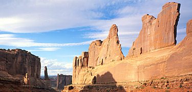
Arches National Park - photo by US Park Service
Bryce Canyon
National Park http://www.nps.gov/brca/
Bryce Canyon is a small national park in southwestern Utah. Named after the Mormon Pioneer Ebenezer Bryce, Bryce Canyon became a national park in 1924.
Bryce is famous for its worldly unique geology, consisting of a series of horseshoe-shaped amphitheaters carved from the eastern edge of the Paunsaugunt Plateau in southern Utah. The erosional force of frost-wedging and the dissolving power of rainwater has shaped the colorful limestone rock of the Claron Formation into bizarre shapes including slot canyons, windows, fins, and spires called "hoodoos." Tinted with colors too numerous and subtle to name, these whimsically arranged rocks create a wondrous landscape of mazes, offering some of the most exciting and memorable walks and hikes imaginable.
Ponderosa pines, high elevation meadows, and fir-spruce forests border the rim of the plateau and abound with wildlife.

Holy Ghost Petrographs, Canyonlands National Park - photo by US Park
Service
Canyonlands National
Park http://www.nps.gov/cany/
Canyonlands National Park preserves a colorful landscape of sedimentary sandstones eroded into countless canyons, mesas and buttes by the Colorado River and its tributaries. The Colorado and Green rivers divide the park into four districts: the Island in the Sky, the Needles, the Maze and the rivers themselves. Mixed stands of pinyon pine and Utah juniper cover millions of acres in the southwest. These trees grow closely associated and dominate the landscape in dry, rocky terrain at elevations between 4,500 and 6,500 feet. In Canyonlands, pinyon-juniper woodlands thrive on mesa tops like the Island in the Sky and the Orange Cliffs west of the Maze. As elevation decreases, trees become more scattered.

Fall Colors in Horseshoe Canyon, Canyonlands National park - photo by
US Park Service
Capitol Reef
National Park http://www.nps.gov/care/
The Waterpocket Fold, a 100-mile long wrinkle in
the earth's crust known as a monocline, extends from nearby Thousand
Lakes Mountain to the Colorado River (now Lake Powell). Capitol Reef
National Park was established to protect this grand and colorful
geologic feature, as well as the unique historical and cultural history
found in the area..
Cedar Breaks National Monument http://www.nps.gov/cebr/
A huge natural amphitheater has been eroded out of the variegated Pink
Cliffs (Claron Formation) near Cedar City, Utah. Millions of years of
sedimentation, uplift and erosion have created a deep canyon of rock
walls, fins, spires and columns, that spans some three miles, and is
over 2,000 feet deep. The rim of the canyon is over 10,000 feet above
sea level, and is forested with islands of Englemann spruce, subalpine
fir and aspen; separated by broad meadows of brilliant summertime wild
flowers.
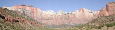
Mount Zion National Park - photo by US Park Service.
Zion National
Park http://www.nps.gov/zion/
Protected within the park's 229 square miles is a
dramatic landscape of sculptured canyons and soaring cliffs. Zion's unique geographic location and variety of life zones combine to create a variety of habitats for a surprising array of plant and animal species. Located on the Colorado Plateau, but bordering the Great Basin and Mojave Desert Provinces, Zion is home to plants from each region. Elevations range from 3600 to 8700 feet. Within these life zones are desert, canyon, slickrock, hanging garden, riparian, and high plateau environments. With over 900 species, Zion National Park contains the highest plant diversity in the state of Utah.
GORP
- Utah Wilderness Areas http://gorp.away.com/gorp/resource/us_wilderness_area/ut.htm
Ashdown Gorge, Box-Death Hollow, Dark Canyon, Deseret Peak, High Uintas, Lone Peak, Mount Naomi, Mount Nebo, Mount Olympus, Mount Timpanogos, Pine Valley Mountain, Twin Peaks, Wellsville.
Jardine Juniper
Trail http://www.utahmountainbiking.com/trails/jardine.htm
Why would you bike 1850 vertical feet just to look at a tree? If you
have to ask the question, you aren't a mountain biker. The Jardine
Juniper Trail is a nice hill climb, and worth doing just for the ride.
At its end point there are great views, plus Utah's oldest tree -- the
Jardine Juniper.
|