|
==============================================================================
TOPIC: Turtle Mountains, ND
http://groups.google.com/group/entstrees/browse_thread/thread/b8a3252554a61ca3?hl=en
==============================================================================
From: ForestRuss@aol.com
To: entstrees@googlegroups.com
Sent: Thursday, April 10, 2008 9:21 PM
Subject: [ENTS] Re: yellow poplar leaves bud break
Lee:
I attended NDSU Bottineau for my first two years of forestry school
and got to see a lot of the state when I had chances to go home on
weekends with fellow students. The incredible fertility of the Red
River valley just blew me away and the 12 foot drop in elevation as
you enter the actual flood plain of the valley is the most noticable
12 foot elevation change I have ever witnessed.
Bottineau where the forestry school is (or was) located is a small
town about 80 miles north of Minot and at the base of the Turtle
Mountains. I got to learn all sorts of interesting geologic history
there but what sticks with me the most was that the Turtle Mountains
are the terminal moraine for one major ice sheets from the last ice
age. The elevations were about 300 feet higher than the incredibly
flat northern Great Plains to the south of the mountains and you
could easily see 100 miles.
There were several tree species in the Turtle Mountains that would
not exist any other place in ND which was 50th of all the states in
total acreage of forest cover.....behind Rhode Island by a couple
hundred thousand acres.
At that time (the late 60s) they were concerned about Devils Lake
drying up...a few years ago I read that because of wet weather it
had expanded and covered more square miles than any time ever.
Russ
==============================================================================
TOPIC: ENTS] Turtle Mountains, ND
http://groups.google.com/group/entstrees/browse_thread/thread/9e81de996ccfa2de?hl=en
==============================================================================
== 1 of 3 ==
Date: Thurs, Apr 10 2008 7:40 pm
From: Lee Frelich
Russ:
Yes, its so flat between Fargo and Grand Forks that it makes curbing
on the
side of the streets look like hills. Thats one reason why its so
hard to
model biome distribution in the area. Some models indicate that
northwestern MN and northeastern ND should be part of the boreal
forest. In
reality, the prairie-forest border goes almost straight north in
that area,
and is to the east of the Red River of the North, in MN and there is
very
little forest in ND, just a few patches in the Turtle Mountains. Its
one
of the sharpest prairie-forest borders in the world, going from
boreal
forest to prairie in about 30 miles, and no one can really explain
why,
although one of my graduate students is taking on that task. Maybe
it has
to do with the snow--there is always more snow cover to the east in
MN.
Lee
== 1 of 1 ==
Date: Thurs, Apr 10 2008 6:53 pm
From: "Edward Frank"
Russ,
The Turtle Mountains sound like an interesting place. It made me
look up the area on the internet. If others are interested there is
a nice website about the area:
https://www.dmr.nd.gov/ndgs/ndnotes/ndn15-h.htm from the North
Dakota Geological Survey North Dakota Notes No. 15.
The site reads in part: "The predominant covering of aspen is
interspersed with black poplar, ash, birch, box elder, elm, and bur
oak. A large part of the vegetation consists of shrubs like hazel,
chokecherry, saskatoon, nanny berry, dogwood, highbush cranberry (Pembina),
and pincherry. Fire played an important role in the development of
present-day vegetation. Prior to settlement, the Turtle Mountains
were periodically swept by fire caused by lightning and by human
activity. Plains Indians noticed that a heavy growth of new plants
appeared in burned areas. They also knew that forests did not
attract bison so they routinely set fire to the wooded areas.
Prairie winds then carried the fires for many miles. This practice
may represent one of the earlier attempts by man to attract animals
by manipulating the environment."
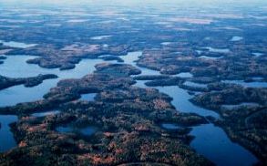
Landsat Image of the Turtle Mountains: http://www.ndsu.edu/nd_geology/nd_space/landsat3.htm
Turtle Mountains State Forest: http://www.ndsu.nodak.edu/ndsu/lbakken/forest/stateforest/turtle_mtn.htm
The Turtle Mountain State Forest is the largest block of forested
land in the State Forest system. It contains examples of prairie
grasslands, at the south end, with steep draws and oak Savannah
forests. As you climb out of the foothills heading north towards the
Canadian border, you will experience dense aspen forests, mixed
hardwood forests, small lakes and wetlands. Wildlife is abundant
with deer, moose, ruffed grouse, waterfowl and songbirds common.
There is an extensive trail system for hiking, mountain biking and
horseback riding during the summer and snowmobiling and
cross-country skiing in the winter. Within the boundaries of the
State Forest are Strawberry Lake Recreation Area, Hahn's Bay
Recreation Area and Twisted Oaks picnic area. All provide trail head
access to the trail system.
https://www.dmr.nd.gov/ndgs/ndnotes/ndn14_h.htm
Ecoregions of North and South Dakota: http://www.npwrc.usgs.gov/resource/habitat/ndsdeco/46b.htm
Ed Frank
==============================================================================
TOPIC: Turtle Mountains, ND
http://groups.google.com/group/entstrees/browse_thread/thread/b8a3252554a61ca3?hl=en
==============================================================================
== 1 of 1 ==
Date: Thurs, Apr 10 2008 7:35 pm
From: ForestRuss@aol.com
Ed:
Thanks for the links...It brought back lots of memories and reminded
me of
how much I have forgotten.
Russ
|