ENTS--
I was recently returning from a meeting on the Kisatchie
National Forest
in Louisiana and since the opportunity arose, I drove somewhat
east just
into Mississippi along the Loess Bluffs. Along this stretch of
the
Natchez Trace, the road winds through woods, farms, and wetlands
just
east of the bluff line. Most of the timber is young, and in many
places
represents reforesting farmland. About 18.4 miles from the
beginning of
the Trace's route northward from Natchez is a parking area and
nature
trail called "Bullen Creek" which has a number of
interpretive signs
focusing on the past land-use history (former ag land) and
success of
the forest from pine to hardwood. The trees looked fairly tall
and the
afternoon, though waning, was one of those brilliantly lit fall
days
that just cries out for a hike. Initially, I did not plan to lug
the
Impulse into the woods, but as I walked along this short trail,
I
realized that the trees were indeed pretty tall and some
appeared worthy
of further enumeration. So I went back to my vehicle and got the
laser
gun and DBH tapes, and plunged into the woods along the trail.

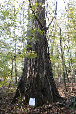
Cherrybark Oak
This area is covered with a thick layer of loess, or silty,
yellowish
wind-blown materials deposited on the uplands to the east of the
Mississippi River. Most of these deposits date back to when the
ancestral Mississippi and other large rivers, swollen with
glacial
meltwater, kept much of the current Lower Mississippi River a
broad,
braided, sediment-laden system. These sites have long since
revegetated, and are considered quite productive if highly
erosible.
Earlier this summer I had sent the ENTS website a picture of a
gulley
eroded into a landform called "Crowley's Ridge" in
eastern
Arkansas--this landform is comparable to the Loess Bluffs of
Mississippi. Along much of the lower parts of the Loess Bluffs,
the
Natchez Trace National Parkway winds scenically through the
landscape.
There is an incredible amount of human history along this narrow
path--ancient Indian mounds and villages sites, historic inns
and other
structures, Civil War battlefields, etc. If you ever get the
chance,
and have some time to spend (speed limits are lower on this
scenic
byway), the Natchez Trace covers a lot of beautiful countryside
in the
South.

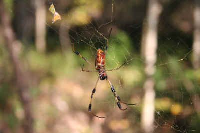
Banana Spider
Dodging several large golden silk spiders (a.k.a. "banana
spiders"--the
one in the picture I'm sending Ed for the website was probably
about 3
inches long, including legs), I quickly started measuring the
most
prominent trees. Loblolly pine still dominates most of the
overstory,
although it is starting to die out and is being replaced by a
mixture of
oaks, gum, and yellow-poplar. The understory is primarily red
maple,
eastern hophornbeam, with some holly, magnolia, and a number of
other
species. The fading daylight kept me from lingering too long,
but this
site shows some of the potential of the Loess Bluffs:
Species DBH (in.)
CBH (ft.) SineHT (ft)
Loblolly pine 31.6 8.3 127
Yellow-poplar ~27 ~7 117
DBH estimated-vines
Yellow-poplar 37.8 9.9 137
Loblolly pine 35.0 9.2 133
Water oak 34.4 9.0 118
Cherrybark? oak 43.3 11.3 117
forked tree
Cherrybark? oak ~60 15.7 116
DBH estimated-vines
Cherrybark? oak 55.5 14.5 n/a
fairly short old-field tree
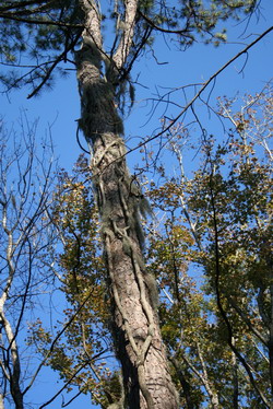
This site is South enough that there are small quantities of
Spanish
moss dangling from some of the branches. Getting diameter on
some of
these trees was hard due to large amounts of vines, especially
poison
ivy. I can also guarantee that these heights probably do not
reflect
the highest parts of the crowns of these trees--due to fading
light
conditions, I focused more on getting a reasonable approximation
of
height, and did not scan the crowns thoroughly for higher
branches. The
probable cherrybark oaks (they didn't quite looks as I would
have
expected them to, but this could just be some of the
considerable
variation in the appearence of the red oak group) were along a
small
creek (probably Bullen Creek), and appear to be noticeably older
than
the rest of the stand. Most of the timber here is probably 60 to
80
years old, and apparently seeded in an old field. The largest
cherrybarks still have vestiges of their open-grown origins,
with broad,
spreading crowns and thick branches. I did not spot the largest
of the
cherrybarks until I was packing up my stuff to leave, as it was
not
along the trail I followed, but rather just off the corner of
the
parking area. It is an impressive tree, with many lianas draped
off of
it.

Loblolly Pine
I realize that I did not measure enough trees for even a 5
species
Rucker Index, but it would be possible to do so. There were a
number of
other species that I skipped by in my hurry, including shortleaf
pine,
sweetgum, and probably a number of other oak species. I also
only
covered a small part of the acreage at this site, and more
height
probably could be squeezed out of the trees I did measure. Most
importantly to me, this quick visit suggests the big tree
potential of
the Loess Bluffs area of Mississippi and Tennessee (the Meeman-Shelby
State Forest that Will and Jess visited has some of these loess
hills on
parts of it). I would think that some of the steep ravines right
at the
junction of the Mississippi Delta and the Loess Bluffs may hold
some
really tall specimens. There are a number of areas worthy of
checking
that are publicly accessible like the Natchez Trace and a number
of
Civil War battlefields and National Wildlife Refuges, so stay
tuned for
further updates!!
Don Bragg
*****************
Don Bragg, Ph.D.
Research forester
*****************
|