|
==============================================================================
TOPIC: McKittrick Canyon, Texas
http://groups.google.com/group/entstrees/browse_thread/thread/653f7255ae0188ca?hl=en
==============================================================================
== 1 of 1 ==
Date: Sat, Mar 29 2008 7:36 pm
From: "Edward Frank"
ENTS,
I want to take a trip on the Wayback Machine and revisit a place I
have not bee to for years - McKittrick Canyon, in Guadalupe National
Park, Texas. The park is located just south of the New Mexico border
in western Texas between El Paso and Carlsbad.
McKittrick Canyon is cut into the Guadeloupe Mountains and contains
a relict population of ice age flora growing along an intermittent
stream. The trees include among others Big Tooth maple, Texas
Madrone, Little Leaf Walnut, Honey Mesquite,, and Mexican Buckeye.
At higher elevations are Juniper, Pinyon Pine, Douglas Fir, and
Ponderosa Pine.
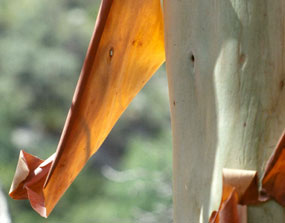 Texas Madrone (NPS Photo) - Cookie Ballou. The Texas madrone - a
rainforest relict tree - grows to about 30 feet. It has a gnarled
trunk with reddish bark that peels with age.
Texas Madrone (NPS Photo) - Cookie Ballou. The Texas madrone - a
rainforest relict tree - grows to about 30 feet. It has a gnarled
trunk with reddish bark that peels with age.
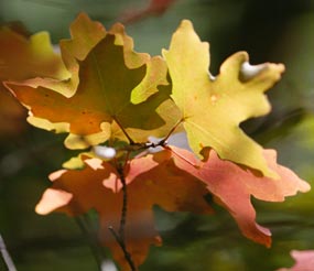 Bigtooth Maple in Fall (NPS Photo) - Cookie Ballou. Though much of
the park is beautiful desert terrain, most park visitors prefer to
hike trails that take them into the trees.
Bigtooth Maple in Fall (NPS Photo) - Cookie Ballou. Though much of
the park is beautiful desert terrain, most park visitors prefer to
hike trails that take them into the trees.
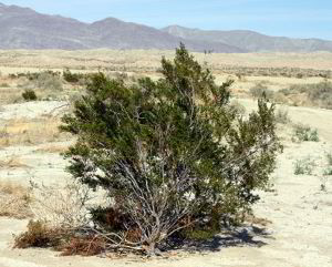
This is is sharp contrast to the Chihuahuan desert flora more common
in the area. These include Prickly Pear cactus, Agave, Creosote
Bush, Ocotillo, Choya, and a wide variety of other desert scrub and
cacti.
 NPS Photo - Cookie Ballou
The NPS website describes the canyon: "While
the towering walls of McKittrick Canyon protect the riches of
diversity, its precious secrets are hidden in riparian oasis. It is
no wonder that it has been described as the "most beautiful
spot in Texas." But for all its magical power that delights
thousands of people each year, its fragility reminds us that our
enjoyment cannot compromise its necessity for survival. It must
survive - not for us, but for all that lives within. Thousands of
visitors come to Guadalupe Mountains National Park to visit
McKittrick Canyon each year, especially during the latter part of
October or early November for the sensational fall colors. In this
tiny part of west Texas, the foliage (brilliant reds, subtle
yellows, and deep browns) contrasts dramatically with the flavor of
the arid Chihuahuan desert that includes century plants, prickly
pear cacti, blacktail rattlers, steep canyon walls and crystal clear
blue skies. Whether you come for the fall show, or plan your trip
for another season, the beauty of McKittrick Canyon is always
breathtaking."
Having grown up in the Eastern United States, and seeing the fall
colors here, I am afraid I must agree , the fall colors of
McKittrick Canyon are among the most spectacular I have seen
anywhere. There is the bright colors of the maples standing in sharp
contrast to the stark surroundings. There are the strange
juxtapositions of epiphytic prickly pear cactus and mistletoe
growing among the tree branches. The Texas Madrone, a strange tree
to 30 feet high, with reddish bark that peels off to reveal a white
under-bark adds a further taste of exotic to the scene. I have many
photos of the area, but unfortunately these are in slide format, and
I have yet to scan them. I do have a couple shots I scanned from
older (faded) prints below. I visited Guadalupe National Park and
McKittrick Canyon many times during the period I worked at Carlsbad,
NM.
Origin of the Park
The NPS website gives a brief history of Guadalupe National Park: "In
1921, a young geologist named Wallace E. Pratt came to McKittrick
Canyon. He was captivated by its beauty and geology and began buying
land in the canyon. In 1931-32, he had a cabin built at the
confluence of north and south McKittrick. The magnificent structure,
built only of stone and wood, was furnished with rough plank
reclining chairs, four beds, an assortment of hammocks, and a
special table to seat twelve. The cabin served as his part-time home
and summer retreat."
 NPS Photo - In 1957, Wallace Pratt donated 5,632 acres of his
beloved McKittrick Canyon to the U.S. Government which formed the
core of Guadalupe Mountains National Park.
NPS Photo - In 1957, Wallace Pratt donated 5,632 acres of his
beloved McKittrick Canyon to the U.S. Government which formed the
core of Guadalupe Mountains National Park.
In 1957, Wallace Pratt donated 5,632 acres
of his beloved property to the U.S. Government for the creation of a
national park. His gift along with a 70,000 acre purchase from J.C.
Hunter Jr.'s Guadalupe Mountain Ranch ensured that Guadalupe
Mountains National Park was authorized by congress in 1966, and
officially opened to the public in 1972. Wallace Pratt died on
Christmas Day, 1981; he was 96 years old. As per his request, his
ashes were spread over the canyon he loved. The Stone Cabin remains
as a monument to this pioneer conservationist."
Geology
In Guadalupe National Park, Carlsbad Caverns National park
immediately to the north, and the Guadalupe Mountains in beyond
Carlsbad Caverns in an exposure of one of the most extensive fossil
reef complexes in the world. The core of the reef is made of the
Capitan Reef Formation, a limestone deposit dating from the Permian
Period around 250 million years ago. This reef formed around a vast
tropical sea covering much of west Texas and southeastern New
Mexico.

http://www.nps.gov/gumo/naturescience/upload/reefmap.pdf
In terms of scale think of it as being similar nature to the Great
Barrier Reef off Australia's eastern coast today. When people think
of reefs, they see hoards of fish swimming among corals. That is
true, but the vast bulk of the calcite deposited in reefs are
deposited by the much less spectacular calcareous sponges, algae,
and other lime secreting organisms. The Permian reef ran parallel to
the coast for 400 miles. The Texas version of El Capitan, Guadalupe
Peak, the tallest mountain in Texas, and Carlsbad Cavern in New
Mexico are all exposures or developed within the core reek itself.
The "complex" represents the reef itself and deposits
behind the reef and in the central basin itself. This area in the
center is called the Permian Basin and is the foremost oil producing
section of western Texas.
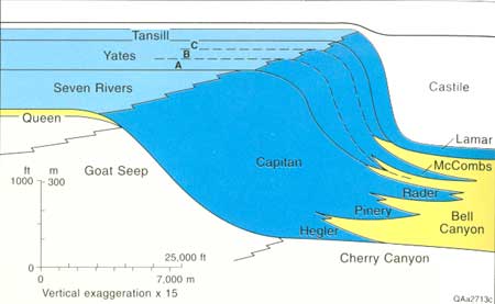
Cross section showing shelf-to-basin correlations of the Capitan
Formation and equivalents. Blue areas are dominantly carbonates and
evaporites, and yellow areas are mostly sandstone. Modified from
Garber and others (1989). http://www.nps.gov/history/history/online_books/gumo/1993_26/intro.htm
The above diagram is a simplified cross-section of the major
geologic formations in the reef complex. The actual interfaces
between the various units are more complex, but this is a fair
generalization of the geology of the area. More detailed
descriptions of the reef complex can be found at the link above and
at this site: http://geoinfo.nmt.edu/staff/scholle/guadalupe.html
- An Introduction and Virtual Geologic Field Trip to the Permian
Reef Complex, Guadalupe and Delaware Mountains, New Mexico-West
Texas by Peter Scholle.
The NPS Website http://www.nps.gov/gumo/naturescience/geologicformations.htm
reads: "During the late Permian
Period, a reef developed near the border of the Delaware Sea. This
was the Capitan Reef, recognized as one of the premier fossil reefs
of the world and best exposed in the Guadalupe Mountains. Growth of
this massive reef ended near the close of the Permian Period. For
several million years, the reef had expanded and thrived along the
rim of the Delaware Basin, until events altered the environment
critical to its growth. The outlet to the ocean was restricted and
the Delaware Sea began to evaporate faster that it could be
replenished. Minerals began to precipitate out of the vanishing
waters and drift to the seafloor forming thin bands of sediments.
Gradually, over thousands of years these thin bands entirely filled
the basin and covered the reef." This massive
evaporation led to the deposition of the Castille Formation. This
deposit is an amazing 1500 to 2000 foot thick mixture of interbedded
gypsum and salt deposited in a period of about 100,000 years. I
found a photo of a sample from the unit at: http://clasticdetritus.com/2007/12/15/a-few-of-my-favorite-pet-rocks/

Each of the layers in the rock represents the deposition of one year
of sediment. The darker layers are those that incorporate some
terrestrial sediment washed in during the wet season into the
semi-enclosed basin. For the most part the unit was deposited as
gypsum with some salt layers as well. There is no real parallel to
this process gong on today, but the closest would be some of the
fingers off the Red Sea. As sea water evaporates the components
dissolve in the water precipitate out in a certain order. First
precipitated is calcite CaCO3, This precipitated near the inlet of
the basin and served to further restrict water low inward. The next
component that drops out is gypsum CaSO4 · 2H2O. With further
evaporation the next to precipitate is salt NaCl. Finally with
complete or near complete evaporation the most soluble components,
KSO4, MgSO4, KCl, and MgCl, collectively known as potash
precipitate. There are deposits of these minerals in eastern New
Mexico that have been deep mined. One of these sites was used to
house the WIPP, the Waste Isolation Pilot Project to house low level
nuclear waste - items such as gloves used by people handling
radioactive materials and the like. In the short period of time of
Castille deposition the basin deepened as more material was
deposited. This sagging under the weight of the mineral deposits
allowed the accumulation of such a thick deposit in what was a very
shallow sea basin. The Castille Formation is interesting. Hundreds
of cores have been drilled through the rock in search for oil. Near
the base the layers are often contorted and twisted looking much
like a marble cake. This is a result low grade, low temperature, and
low pressure metamorphism of the gypsum CaSO4 · 2H2O to anhydrite
CaSO4 . In this process the mineral recrystalizes into a different
crystal form expelling the water from the mineral structure. The
downside is that the volume of the anhydrite plus the expelled water
is larger than the gypsum was originally. Therefore the pressure
created by increased volume causes the layers to swirl to relieve
the pressure. Uplifts and tilting of this region It is a really
great place geologically.
Prehistory
The NPS website reads: "According to
archeological evidence unearthed in and near the canyon, the
earliest inhabitants occupied the area over 12,000 years ago. Only
stone-chipped tools, bone fragments and bits of charcoal remain to
reconstruct the ways of their lives. More recent discoveries, such
as mescal pits and pictographs, help weave a more complete story of
prehistoric life in the Guadalupes. Much later in history, around
the early 1500s, the Mescalero Apaches inhabited the canyon. The
Guadalupes provided ample supplies of game, water, and shelter
locations, and remained their unchallenged sanctuary until the
arrival of settlers, cattle drovers, and stage lines. As the land
was taken from the Indians, conflicts arose. Skirmishes turned to
bloody battles. Settlers demanded protection. The Mescalero were
forced from the area as cavalry troops penetrated the Guadalupes,
raiding and destroying Apache rancherias, rations and supplies. By
the late 1800s, nearly all of the surviving Mescalero Apaches in the
U.S. were on reservations. Eventually the rugged land was tamed for
ranching and farming. Grazing and hunting activities took their toll
as fences went up. Wildlife disappeared - Merriam's elk, desert
bighorn sheep, and blacktail prairie dogs were all extirpated from
the Guadalupes as a result of extensive hunting and trapping. Though
settlement occurred slowly in the Guadalupes, people were here to
stay. McKittrick Canyon was named for one of those settlers -
Captain Felix McKittrick, a rancher who moved to the mouth of that
canyon in 1869."
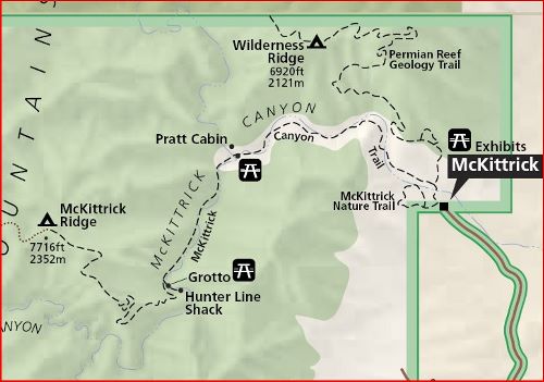
McKittrick Canyon Trailhead
There are a number of places you can visit at Guadalupe Mountains
National Park, I will concentrate on the McKittrick Canyon area.
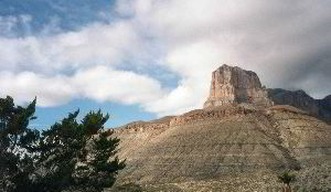
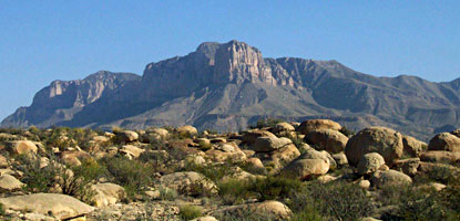
The signature peak of the Guadalupe Mountains, 8,085-foot El
Capitan. (NPS photo by Cookie Ballou)
At the McKittrick Canyon trailhead there are three trails to choose
from. The first is the McKittrick Canyon Nature Trail. This is a
no-brainer to visit. It is a short trail that everyone should
explore before moving onto longer trails. The NPS website reads:
"McKittrick Canyon Nature Trail - An intermittent seep lies
hidden within junipers, shrubs, and grasses that cling to this tiny
ecosystem. Trailside exhibits describe common plants, reference
wildland fire, and explain Permian Reef geology. The trail is .9
miles round trip, is rated moderate, but takes less than one hour to
complete."
The next choice is between the McKittrick Canyon Trail and the
Permian Geology Trail. The Permian Geology Trail leads eastward and
upward toward Wilderness Ridge. The trail includes a series of
interpretive displays and sign explaining the geology of the park as
well as spectacular views from atop the ridge. The trail is 8.4
miles round-trip, and is rated strenuous with 2,000 feet of
elevation gain.. The McKittrick Canyon Trail follows along the
course of an intermittent stream along the bottom of McKittrick
Canyon before rising to McKittrick Ridge and points farther west.
The mouth of the canyon starts out in the Chihuahuan Desert. The NPS
website reads: "The mouth of
McKittrick Canyon is predominately scrub desert where yuccas like
the "Spanish bayonet" (Yucca faxoniana), sotol (Dasylirion
leiophyllum), and ocotillo (Fouquieria splendens) thrive. To the
untrained eye, it seems impossible for anything to grow in such
harsh conditions, yet the plants have evolved to meet the
challenge."
 Torrey Yucca
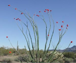 Ocotillo-
the plant only has leaves when there is wet weather. Individually
they resemble barberry leaves. During dry periods the ocotillo oses
its leaves and flowers and resembles a bouquet of dried sticks
standing upright in the desert. Ocotillo-
the plant only has leaves when there is wet weather. Individually
they resemble barberry leaves. During dry periods the ocotillo oses
its leaves and flowers and resembles a bouquet of dried sticks
standing upright in the desert.
Several species of prickly pear cacti (Opuntia
sp.) live in the canyon as well. Their beautiful yellow-orange
blossoms can be observed across the landscape in late spring, and if
your timing is right, you may also enjoy the brilliant red-orange
blossoms of the claret cup cacti (Echinocereus triglochidiatus).
 Cactus
bloom - photo by Edward Frank Cactus
bloom - photo by Edward Frank
Cacti and other desert succulents avoid
drying out by storing water in their succulent tissues. To protect
from water evaporation, the stems have a thick waxy coating. Their
leaves, reduced to needles, provide protection from predators while
reflecting the radiant heat of the sun."
From this entrance area the trail takes you under the trees of the
main canyon itself. The NPS website: http://www.nps.gov/gumo/naturescience/trees.htm
and http://www.nps.gov/gumo/naturescience/shrubs.htm
provides a description of some of the more prominent trees and
shrubs that you will encounter on the trip. It is also worthwhile to
pick up a guidebook for the area before arriving that identifies a
broader range of plant species and you can also carry it with you as
you explore.
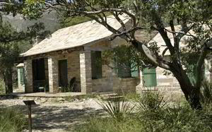 Pratt
Cabin NPS Photo - Cookie Ballou. During summers when Houston, Texas
is hot and humid, the Pratts and their three children spent time in
the Guadalupes, sharing the cabin with friends. Pratt
Cabin NPS Photo - Cookie Ballou. During summers when Houston, Texas
is hot and humid, the Pratts and their three children spent time in
the Guadalupes, sharing the cabin with friends.
Enjoy the shortest distance into the heart
of the canyon by hiking to Pratt Cabin and return (a distance of 4.8
miles). Along this walk you will cross the stream twice before
arriving at the historic structure. Enjoy a snack or lunch at the
picnic tables near or at Pratt Cabin, or sit for a spell on the
porch. Volunteers staff Pratt Cabin much of the year; take a look
inside the stone structure.


Two McKittrick Canyon Views - photos by Edward Frank
The Grotto
As you continue your hike beyond Pratt Cabin to the Grotto, the
forest becomes denser as the trail runs parallel to the stream.
Rainbow trout are visible in the clear water. At the junction ahead
(approximately 1 mile), take the left fork to go to the Grotto.
There, the dripping water percolates through the limestone,
methodically redistributing calcium carbonate into stalagmites and
stalagmites in the tiny "cave." Rock benches and tables
await you in the deep shade, a tempting location for a picnic.
Follow the stone path from the Grotto to Hunter Cabin, a structure
which was once part of a hunting retreat. Look up the canyon slope
and see the steep switchbacks where the trail continues to
McKittrick Ridge. Round-trip distance from the contact station to
the Grotto is 6.8 miles.
McKittrick Ridge
If you have the endurance and the time, take the right fork at the
Grotto trail junction and continue toward McKittrick Ridge. This
arduous hike takes you up the steepest trail in the park. In a mile
or so the trail passes through "The Notch", where there is
a spectacular view of the canyon both directions. As you continue,
don't be fooled by the false summits that make you think you've
nearly reached the top! The hike from the contact station to the
ridge and back is 14.8 miles. (7.4 miles one way to McKittrick Ridge
Campground).
 Creosote Bush - (NPS photo) Larrea tridentata is one of the most
long-lived and abundant desert plants of North and South America. It
is often found in pure stands. The small, leathery, evergreen leaves
occur in pairs united at the base. When it rains, five-petaled
flowers appear and the air is permeated with the fragrance of
creosote bush. The fuzzy white seed balls are relished by rodents.
When crushed, the resinous leaves smell like the petroleum.
Creosote Bush - (NPS photo) Larrea tridentata is one of the most
long-lived and abundant desert plants of North and South America. It
is often found in pure stands. The small, leathery, evergreen leaves
occur in pairs united at the base. When it rains, five-petaled
flowers appear and the air is permeated with the fragrance of
creosote bush. The fuzzy white seed balls are relished by rodents.
When crushed, the resinous leaves smell like the petroleum.
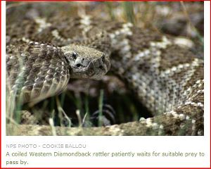
You are likely to encounter a number of wildlife species on your
travels. There are plenty of small lizards - skink, horned lizards,
collard lizard. There are a variety of snakes including western
diamondback.
There are a variety of birds and mammals also. Mammal, bird, and
reptile checklists are available from the Natural History
Association bookstore located at the Headquarters Visitor Center.
There are over 50 species of mammals alone, and more than 300 bird
species that live in, or migrate through the park. 40 of those have
been known to nest in McKittrick Canyon.
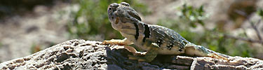
I had an unusual encounter with collard lizard while photographing
at Carlsbad Caverns. I was exploring a short trail just off the cave
entrance. There was a collard lizard posing in the sun, so I
squatted down to take a photo. I had a short 200mm telephoto lens on
my camera and was snapping away, when the lizard started to
approach. Soon it was within the minimum focal length of my lens. So
I just sat there and watched. Eventually it approached within 3
feet. The next thing knew the lizard had launched itself at me and
landed on my leg. I jumped and fell over defeated by an 18"
long lizard. Oh well,.at least I lived to fight another day.
Edward Frank
==============================================================================
TOPIC: McKittrick Canyon, Texas
http://groups.google.com/group/entstrees/browse_thread/thread/c1fd0f043eb53f00?hl=en
==============================================================================
== 1 of 2 ==
Date: Wed, Apr 30 2008 10:06 am
From: ForestRuss@aol.com
Ed:
I spent a week in that part of Texas in 1986 when Halleys Comet paid
its
last visit. I went to Big Bend NP because I figured it would be one
of the
darkest places in the country to see it (because you had to go that
far south to
even see it). I hiked to the top of the Chisos Mountains and sat at
the edge
of the 1000 foot cliff and waited, and waited...it wasn't until I
noticed
that what looked like a 15 watt light bulb in a refrigerator rising
straight up
into the sky from the due south that it was going to be a bust. I
ended up
spending several days in Guadalupe NP and I climbed both Guadalupe
Peak and
hiked McKittrick Canyon...the thing that resonated with me the most
was all the
species of trees that are found there as glacial remnants and in
many cases
more than a thousand miles out of their modern range. You wrote an
exceptional report on a unique part of the country. The white pine
trees in the
Guadalupe Mountains were nuked by major forest fires a few years
ago.
Russ
== 2 of 2 ==
Date: Wed, Apr 30 2008 10:21 am
From: "Edward Frank"
Russ,
I enjoyed hikes tat McKittrick Canyon numerous times, but haven't
made it to Big Bend yet. I posted to try to expand the
"range" of areas being discussed in the list. I thought
the glacial remnant populations were an unusual subject to be
broached on the list, but this is actually the first response to the
McKittrick Canyon post. If you hear anymore about the Webster
Sycamore live/dead status let us all know.
Ed
|