| Shingletown
Gap, Centre County |
Ernie
Ostuno |
| Jul
26, 2004 01:35 PDT |
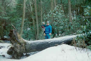 |
Large uprooted hemlock in the stream valley. A
separate area of old growth occurs on the ridge top near here. Photo
taken January 1999.
|
I have visited this site several times, most recently on
3/15/02. Two
areas of old growth can be found here and they separated by
second
growth mixed oaks. About 10 acres of mature and old growth
hemlock,
white pine and hardwoods are in a stream valley/water gap, and
another
20 acres of old growth (again primarily hemlock) are on north
side of a
ridge top. Most of the trees in the valley are concentrated
right along
a stream. About one acre was cleared for a water filtration
pond. A ring
count on a fallen hemlock gave an age of about 210 years.
Several
hemlocks in the valley approached 50 inches dbh and 100 feet in
height,
while those near the ridgetop were smaller; about 40-45 dbh and
80-90
feet tall. Very large rhododendron were noted in the presence of
the old
growth hemlocks,
both on the ridge and in the valley. Both areas of old growth
are
fragmented and surrounded by second growth hemlock, pine and
hardwoods.
A single specimen of old growth red pine was found in the
valley. The
hemlocks on the ridge top were growing in very rocky, poor soil.
|
| RE:
Dale Part 2 |
Ernie
Ostuno |
| Jul
26, 2004 15:27 PDT |
| Shingletown
Gap
Use this
Rothrock State Forest map to find PA Route 45:
http://www.dcnr.state.pa.us/forestry/stateforests/images/roth3.gif
and then this map:
http://www.dcnr.state.pa.us/forestry/stateforests/images/roth7.gif
You will be following a trail along Roaring Run (seen at the
very top of
the map segment in the link above).
Take PA route 45 south from Boalsburg and then take your first
left.
Follow this road a mile or so until you come to a small parking
area in
front of a chain link fence. Park there and walk to your left
around the
fence to the trail head. Follow the trail and stay on the left
side of
the stream. You will see scattered big hemlocks and a few white
pine for
about a mile or so and intermittent patches of big trees and big
individual hemlocks. The lone red pine was about 2 miles back
there,
near where the examples of old growth trees pretty much ends.
To get to the old growth on the ridge you can either head south
on Sand
Spring Trail to hike up the slope from the valley, or you can
drive up
the ridge by using PA 322 to S.R. 2001 to Laurel Run Road. Then
park at
the ridgetop and walk south in the clearing until you reach the
Mid
State trail, which takes you to the old growth, most of which is
on the
north slope, just off the trail.
|
| Shingletown
Gap |
Dale
J. Luthringer |
| Jul
27, 2004 07:30 PDT |
Ernie,
I thought those place names sounded familiar. I tried to get to
Shingletown Gap or nearby on roads, but they were all blocked
off. The
land contours looked promising, but I didn't have time to hoof
it in.
I did take some height data nearby farther down Laurel Run Road
as you
get closer to the Mt. Nittany ski area. There was a nice little
stand
of very mature hemlock on the edge of a steep hill and adjacent
to
Laurel Run Road. I didn't get CBH data, because it had private
property
signs all along the edge of the road. Here is my data set. I'm
wondering if this might be comparable to Shingletown...
Species Height
BB 89.5
BC 115.8
CO 90.6+
CT 95.6+
CT 100.2
EH 111.3
EH 111.8
EH 115.3
EH 118
EH 118.1
EH 123.5
RO 103.4
RM 90.1+
TT 127.5
TT 128
TT 131.1
WP 111.2
YB 90.6
This results in a Rucker Index of 104.6, which seems to be about
average
for a taller growing site in Centre county.
Site Rucker Index
Cook Forest S.P. 135.47
Wintergreen Gorge 128.28
Fairmont Park 127.72
Walnut Creek 121.69
Ander's Run N.A. 121.48
Ricketts Glen N.A. 121.85
Heart's Content N.A. 113.79
Lake Erie Community Park 113.57
Alan Seeger 111.13
Coho Property 109.59
Scott Community Park 109.56
Tionesta N.A. 109.36
Detweiler Run N.A. 104.65
Laurel Run Road 104.6
Glenwood Community Park 98.08
Bear Meadows N.A. 93.3
Parker Dam S.P. 85.57
Dale
|
| RE:
Shingletown Gap |
Ernie
Ostuno |
| Jul
27, 2004 15:50 PDT |
Dale,
There is a decent stand of hemlocks just past the ski area off
Rte. 322;
along the creek as you make your way into the Rothrock. But the
hemlocks
along Roaring Run (off Route 45) are bigger, with some very
large
individuals, along with the occasional big white pine. It would
be
interesting to get some age/size comparison from the trees on
the ridge
and in the valley at Shingletown Gap, to see how growing
conditions
affect sizes for trees of roughly the same age. I talked to a
grad
student at PSU a couple years ago who was doing coring at old
hemlock
stands in Centre County, but i don't know if he had the chance
to do
this.
Ernie
|
| Shingletown
Gap |
Dale
J. Luthringer |
| Feb
14, 2005 16:14 PST |
Bob,
Ernie,
Here's another very late post, but better late than never.
The following tree height data is from my trip to Shingletown
Gap on
11/18/04. Please refer to Ernie's earlier post for a site
description
of old growth and forest species mix. I believe he gives a good
assessment of the area, so I won't take the time to re-iterate.
I parked at the end of the road just below the water treatment
area and
started to walk upstream. I first measured some white pine and
hemlock
just upstream from the plant, then continued to work my way
upstream
about 1.5 miles. The tallest hemlocks and white pines I found
were
again just upstream from the plant. I didn't have time to check
the
ridges, so I decided to concentrate on the stream valley trees
to
increase opportunities to find the tallest trees in the stand. I
was
not able to find the red pine Ernie was talking about. It'll
have to
wait for a future trip.
The largest girthed hemlocks I found were adjacent to the
stream. I'd
estimate some hemlocks in this valley to go near the 350 year
range. If
I had more time, I wanted to check out the section of taller
hemlocks
and thick rhododendron that was just upstream and west of the
water
treatment plant in a boulder filled convex bowl drainage. I just
didn't
have to time to go "rhodo surfing" that day.
The day's stats follows:
Species CBH Height
Am. basswood 4.7 78.2+
Black birch N/A 75.1+
Black gum 3.4 57.1+
Chestnut oak 4.8 78.1+
Chestnut oak 4.8 90.1+
E. hemlock 10.7 100.7
E. hemlock 10.5 109.6
E. hemlock N/A 114.7
E. hemlock N/A 115.1
E. hemlock N/A 116
E. hemlock N/A 122.9
E. white pine N/A 112.7
E. white pine 6.9 117.6
N. red oak 4.6 69.1+
N. red oak 6.7 72.7+
N. red oak 9.2 87.1+
N. red oak 10 87.1+
Pitch pine 3.5 63.8
Red maple 3.8 82.8+
Red maple 5.2 85.1+
Tuliptree N/A 103.9
Tuliptree N/A 115.3
White ash N/A 114.8
White oak 5.8 84.1+
Yellow birch 5.3 78.1+
Yellow birch 4.8 79.5
Shingletown Gap Rucker Index = 97.47
Species CBH Height
E. hemlock N/A 122.9
E. white pine 6.9 117.6
Tuliptree N/A 115.3
White ash N/A 114.8
Chestnut oak 4.8 90.1
N. red oak 10 87.1
Red maple 5.2 85.1
White oak 5.8 84.1+
Yellow birch 4.8 79.5
Am. basswood 4.7 78.2
Here's my most up-to-date list of Pennsylvania Site Rucker
Indices:
Site
Rucker Index
Cook Forest State Park
135.94
Wintergreen Gorge
128.53
Fairmont Park
127.72
Ricketts Glen State Park
126.29
Anders Run N.A.
122.31
Walnut Creek Gorge
121.69
Hemlocks N.A.
114.75
Heart's Content N.A.
113.79
Lake Erie Community Park
113.57
Coho Property
113.19
Alan Seeger N.A.
111.13
Scott Community Park
109.56
Tionesta N.A.
109.36
Allegheny River
104.99
Detweiler Run N.A.
104.65
Laurel Run Rd-Centre County
104.6
Glenwood Park
98.08
Shingletown Gap
97.47
Bear Meadows N.A.
93.72
Parker Dam State Park
85.57
Shingletown Gap was quite an interesting place. There was an old
logging road of sorts that ran right down the center of the
stream
through the gap. Some portions of this road were actually
converted to
hiking trail. If I had more time, I would've liked to explore
the
southern ridge and work my way east. Hemlocks seem to progress
further
up this ridge, and I could still see hemlocks on the ridge as I
walked
about 1.5 miles up the drainage. The flats on the upper end of
the
drainage all appeared to be logged, but it appears that some of
the
ridges were spared. I wouldn't be surprised to find small
stature old
growth in this area.
As a side note, when you pull off RT45 on the short road to the
parking
area of the gap, you pass a small private stand of old oaks on
your
left. The twisted crowns of these trees suggests this small
stand
probably has some age to it. It would be interesting to compare
the
ages of the oaks on the private stand to those in the gap.
Dale |
|