|
==============================================================================
TOPIC: Millstone Creek Area, PA
http://groups.google.com/group/entstrees/browse_thread/thread/a1cc481667139773?hl=en
==============================================================================
== 1 of 1 ==
Date: Wed, Sep 24 2008 9:23 pm
From: "Edward Forrest Frank"
Background - Clarion River Corridor Project
The compilation of various measurement data and the publication of a
Clarion River Rucker Index to the ENTS List on September 12, 2008 by
Dale Luthringer formalized the Clarion River Project and set the
boundaries of the river corridor as a discrete study area. The
corridor is defined to include the flats and flood plains along the
river, the river islands, as well as trees up to a couple hundred
yards up various low lying drainages that flow into river. The
Clarion River begins in north central Pennsylvania flowing first
south then west-southwest for a distance of around 110 miles before
flowing into the Allegheny River five miles below Emlenton. The
river crosses the Allegheny Plateau region and in places forms a
steep-sided valley incised into the landscape. Two sections of the
river totaling 17 miles are classified as scenic and an additional
34.7 miles of the river are classified as recreational as part of
the National Wild and Scenic River System. http://www.fish.state.pa.us/anglerboater/2005/04julaug/spec2clarion.pdf
In the initial compilation the trees listed were primarily from Cook
Forest and Clear Creek State Parks. Other trees that made it onto
the list came from Halton (upstream section) and from the state game
lands downstream from Gravel Lick Bridge. The goal of the corridor
project at this time is to better document the trees along the river
corridor as a whole. The species making up the top ten for the
Rucker Index are close to the maximum heights documented for the
species in the region, so replacing any trees on RI10 list will be
difficult, but not impossible. There also is considerable potential
to find greater heights for other species lower on the list and to
collect information for additional species not already listed.
Another goal is to locate and document other sites along the river
that have large and old trees.
Millstone Creek Area - Background
Millstone Creek flows into the Clarion River approximately 13 miles
upstream of the Cook Forest State Park office. Millstone is also the
location of a long gone lumber town dating from the late 1800's. A
note from: Page(s) 712-716, History of Counties of McKean, Elk and
Forest, Pennsylvania. Chicago, J.H. Beers & Co., 1890, reads
"Here, after the forest strippers began regular lumbering, the
woodman's ax was heard on every side, and within a few years the
pine and hemlock clothing of the flat hills was carried down the
Clarion to the great mills, leaving the traveler of 1878 to behold
as rugged a country as might be seen in Scotland." http://www.pa-roots.com/~elk/history/chapter16.html,
Recent archaeology efforts at the old town site also uncovered
evidence of native American tools, and pottery from the late
Woodland period, A.D. 1250, or roughly 1,000 years ago. These
artifacts and a few archaic grinding holes are among the limited
materials and information we have on early native inhabitants along
the Clarion River. http://www.ridgwayrecord.com/content/view/137545/1/
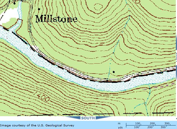

Millstone Creek Area Trees
September 18, 2008: I (Edward Frank) first scouted this site on a
late afternoon trip. I started at Cook forest and drove along the
river upstream to a pull-off area at a set of dispersed campsites in
the southernmost tip of the Allegheny National Forest in the
Millstone Creek area. What attracted me was the very large hawthorn
tree at the pull-off. Dale Luthringer, Anthony Kelly, ad I had found
an measured the national champion Dotted Hawthorn last fall in the
Allegheny River Islands Wilderness on King Island last fall. That
tree measured 39.3 feet tall. This tree was close to that in height.
The tallest hawthorn we documented was 45.4 feet tall at the
Buckaloons Campground also along the Allegheny River/ I walked
around the site and found there were several dozen large hawthorns
in the area, with a number of specimens close to forty feet tall. In
addition were a number of tall and fat oaks, and some good sized
black locust. I started measuring with a red oak 16' 4" girth a
height of 77.4 feet.
·
Red
Oak 16' 4" girth,
77.4 feet tall
·
Hawthorn
girth 2' 5", height 43.4'
·
Black
Cherry, triple trunk cbh13' 3", trunk a: 6' 10", trunk b
7' 5", trunk c 6' 10" measured at 7 feet.
Height 106.9'
·
Apple
- girth 5' 2" (at 2' 8" below fork) 39.5 feet tall
·
Hawthorn
in parking area 39.4
feet high, 4’ 10” girth
·
Hawthorn
back end. downstream of campsite 9:
42.6 feet high, 2’ 9” girth
·
Red
Oak: 109.2 high, girth
12ft 4 inches.
·
White
Oak 14' 8" girth, 98.4 high
·
Black
Locust - large trunk with girth 9 feet , height 90.3’ height.
This is the remaining half of a large double, half of which
has fallen. There are a
number of other black locust in the area I the 90 to 100 foot height
range.
·
One
of three large red oaks - center one measured at 9' 3" girth,
and 104.6 feet tall (need to get a better height)
·
American
Hornbeam: 2' 11"
girth, and 38 feet tall.
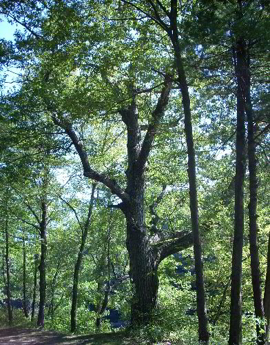
Red Oak 16' 4" girth, 77.4 feet tall
In the area were also white pine, yellow birch, red maple and a few
other species. There are several hawthorns in the 30 to 40 foot
range, several red oaks in the 12 x 100 range, a few more hornbeams
in the same size range as recorded above, and I am sure there were
more specimens and species I didn't notice in the short visit there.
After the trip I went back to Cook Forest to meet with Dale
Luthringer to tell him of the trees found and to organize a trip for
both of us to revisit the site. Dale said he may have measured the
first fat red oak previously, but had not measured other trees in
the area.
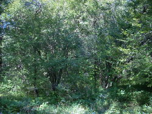
Dotted Hawthorn tangle including a girth 2' 5", height 43.4'
specimen
September 24, 2008: I picked up Dale Luthringer at Cook Forest at
4:00 pm. The goal to day was to explore more of the Millstone Creek
Area and to document more of the tree found there. In addition I
wanted to clean up some of my measurements from the previous trip.
Dale had been past the site before but had never walked it to
measure trees. The first tree measured was the 43.5 foot hawthorn
noted above between dispersed campsite 8 and 9. I had measured a
slightly higher value initially, but the problem was this was a
dense cluster of hawthorns and by myself it was difficult to
determine exactly which trunk was connected to the tallest sprig of
leaves. With a reflector pole, and between the two of us we located
the correct base for the tree and I remeasured the tree to 43.4 feet
in height. (Waypoint 805) 41' 21.105" N, 79' 4.135 W.
White Oak 16.2 feet girth, 72.1 feet tall
We continued up the road (upstream) from this area and looked at the
large 16.4 girth red oak noted above. Continuing on we soon found
another fat white oak across from campsite 10. This tree measured
16.2 feet in girth and 72.1 feet tall. Dale suggested this may have
been a location of a small geocache at one time. Immediately behind
the oak was a beech. It was not that big, but represented the
largest of the species I found in the area. It was 54' tall, and had
a girth of 5' 8." Continuing up the road to campsite 11, we
found a respectable hemlock and a white ash across the road for the
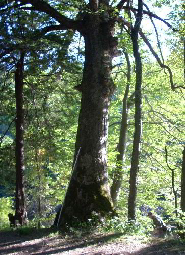
campsite. The eastern hemlock was the fattest I had seen at a girth
of 8.8 feet, and a modest height of 86.7.' Dale measured a white ash
here at 104.7 feet tall, by 7 foot in girth.

White Oak 14' 8" girth, 98.4 high
Returning back toward the car, we remeasured the red oak above,
located between campsite 8 and the pull-off on the river side of the
road at 12'4" girth, and 109.2 feet tall. This is dale's
waypoint 806. We next remeasured the large white oak along the road
I measured previously. I had hit 103 from underneath but was unable
to reproduce that height from an angle. The best I was able to do
from the side was 95.9. I was hoping Dale would do better. From a
different vantage point he found 98.4 feet tall, with a girth of
12.4 feet. Just short of his 12 x 100 listing. We then remeasured
the large black locust from the first trip. It is the remaining half
of what had been a double. The second half had fallen previously
splitting the trunk to the ground. The girth of the remaining half
(with a flat back) was 9 feet and a height of 90.3 feet.

A short distance down the road (downstream toward Millstone Creek)
was one of the largest white pines on the site at 11.8 feet in girth
and 116.9 feet tall. In the bottom below the road and toward
Millstone Creek a large broad crowned red oak could be seen. Dale
bushwhacked to the base of the tree and measured a girth of 14.2
feet. Shooting from the road, and with Dale holding using a 10 foot
pole with reflectors, I was able to get a good height. But no matter
how hard I tried the best height I could obtain was 98.72 feet tall.
Again this was just short of Dale's magic 12 x 100 list.
From here we went back to the pull-off and followed a path to the
river edge. In this area Dale measured a 12.4' girth red oak,that
topped out at 98.3 feet in height. Here I measured a yellow birch 5'
2" girth and 49.5 feet tall. A second fatter yellow birch at 7'
9" girth was broken off about 20 feet up. It would have been a
nice tree as its base was clinging to the lip of a rock edge. In
general it seems that tree immediately along the river tend to be
shorter, often showing top damage. This is to be expected being as
they are on the edge of the forest and winds can whip up and down
the river course.
Dale and I explored the area for awhile at the end looking for other
trees to measure. Dale found a bitternut hickory 85.6 feet tall and
4.7 feet in girth. One thing he also looked for was an old Indian
trail, which had portions of it later converted to a carriage road.
Eventually he located the path, and documented another red oak, the
fattest for the area at 16.6 feet in girth, but just 81.1 feet tall.

Hawthorn in parking area 39.4 feet high, 4' 10" girth
I measured three Bigtooth Aspens: 50.3 feet tall x 1'8" girth;
61.5 feet tall x 1' 11.5" girth, and 73.6 feet tall x 2'
5" girth. In the pull-off area we measured a red maple 83.23
foot tall x 9.9 foot girth. Species present but not measured
included black birch, choke cherry, chestnut oak, and staghorn
sumac. I measured two more hawthorns in the pull-off area: The first
was 41 feet tall, x 2 foot girth, and 32.6 feet tall x 2' 3"
girth. There were many hawthorns in the mid to low thirties in
height, a couple in the upper thirties. We measured three hawthorns
over 40 feet tall, very impressive for the species.
|
Species
|
Girth
|
Height
|
Comments
|
|
Red
Oak
|
16.4
|
77.4
|
Across
from campsite 9
|
|
Red
Oak
|
12.3
|
109.2
|
Waypoint
806, 12 x 100 class
|
|
Red
Oak
|
9.3
|
104.6
|
One
of three red oaks just below road
|
|
Red
Oak
|
14.2
|
98.7
|
In
bottom below pine
|
|
Red
Oak
|
12.4
|
98.3
|
Flat
along the river
|
|
Red
Oak
|
16,6
|
81.1
|
By
Indian Trail
|
|
Hawthorn
|
2.4
|
43.4
|
Waypoint
805
|
|
Hawthorn
|
2.8
|
42.6
|
Backside
campsite 9
|
|
Hawthorn
|
4.8
|
39.4
|
Pull-off
area
|
|
Hawthorn
|
2
|
41
|
Pull-off
area
|
|
Hawthorn
|
2.3
|
32.6
|
Pull-off
area
|
|
Black
Cherry
|
Multi
|
106.9
|
Triple
trunk cbh13.3 feet
|
|
Apple
|
2.2
|
43.4
|
at
2.7 feet below fork
|
|
White
Oak
|
14.7
|
98.4
|
Across
from pull-off
|
|
White
Oak
|
16.2
|
72.1
|
Across
from campsite 10
|
|
Red
Maple
|
9.9
|
83.2
|
At
pull-off area
|
|
Black
Locust
|
9
|
90.3
|
1/2
of double locust - old
|
|
American
Hornbeam
|
2.9
|
39
|
|
|
Beech
|
5.7
|
54
|
Across
from campsite 10
|
|
Hemlock
|
8.7
|
86.7
|
Across
from campsite 11
|
|
White
Ash
|
7
|
104.7
|
Across
from campsite 11
|
|
White
Pine
|
11.8
|
116.9
|
Road
side downstream of pull-off
|
|
Bitternut
Hickory
|
4.7
|
85.6
|
Near
big white oaks and black locust
|
|
Yellow
Birch
|
5.2
|
49.5
|
Along
path from pull-off
|
|
Yellow
Birch
|
7.8
|
20
|
Broken
off top
|
|
Bigtooth
Aspen
|
1.7
|
50.3
|
|
|
Bigtooth
Aspen
|
2
|
61.5
|
|
|
Bigtooth
Aspen
|
2.4
|
73.6
|
Near
road by triple trunk black cherry
|
Rucker
Index: 95.55
There were a surprising number of large trees in the area. Many of
the red oaks nearly 100 feet tall and 12 feet in girth almost
assuredly grew in the period since the virtual abandonment of the
town of Millstone are are likely less than 125 years old. It was
particularly interesting to see the large number of large hawthorns
intermixed with apple trees in the area above the road, and just
hawthorn trees in the area below the road. If these also date from
the period after Millstone, and this is likely, it is a good
indication of how long it takes for a near champion sized tree to
grow. The Rucker Index is relatively low. I am not sure what species
could potentially take the place of Bigtooth aspen at the bottom of
the list. It is possible that yellow birch or black birch might bump
off the aspen. For species on the list with more potential with more
searching at the site, I am sure that a taller yellow birch will be
found, there are also likely taller black locust, white pine, and
hemlock present in the area. The hawthorns are believed to be Dotted
Hawthorns (Crategus punctata).
Edward Frank and Dale Luthringer
==============================================================================
TOPIC: Millstone Creek Area, PA
http://groups.google.com/group/entstrees/t/a1cc481667139773?hl=en
==============================================================================
== 1 of 1 ==
Date: Thurs, Nov 13 2008 7:42 pm
From: "Dale Luthringer"
ENTS,
As Ed says in his post, I did spent a decent bit of time searching
for
an ancient Indian trail that was reported to cross the river in this
area. After some searching, I was able to find the trail. It comes
down off the hill from the northern side of river and probably
originally crossed the river at its shallowest point near the
confluence
of Millstone Creek. It was converted into a buggy road back in the
early 1800's, and remnants of it can still be observed today. The
old
buggy road is actually part of a very long Indian trail known as the
Olean or Catawba Trail.
http://www.waymarking.com/waymarks/WM1RWM
http://www.mcn.org/2/noel/Westmoreland/MigrationTrails.htm
The trail was mainly used by Iroquois for trade between tribes and
to
raid their southern mortal enemies, the Catawbas or Cherokee. Later,
it
was heavily used for trade between with the settlers, then for their
raiding parties during the French & Indian War through Pontiac's
Rebellion. The trail is steeped in history. The Allegheny National
Forest and Clarion University have been pursuing digs in this area
along
the river flats before latrine installation to augment primitive
camping
in this area.
Dale
|