Lower Jerry Run Natural Area, PA
On Sunday May 28, 2006 Anthony Kelly,Jacqui Noel, and myself
(Edward Frank) visited Lower Jerry Run Natural Area in Cameron
County, in north central Pennsylvania. There were a couple of
previous posts on the area from Dale Luthringer and Ernie Ostuno.
Each had reported remnant old growth hemlock near the upper
reaches of the steep valley walls leading down into the valley.
Our goal was to explore more of the natural area and check out
the reported old growth.
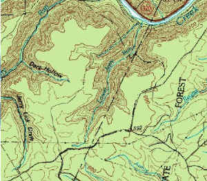
The Pennsylvania DCNR, Department of Forestry described the site
as follows: http://www.dcnr.state.pa.us/forestry/oldgrowth/jerryrun.aspx
Lower Jerry Run Natural Area - 892 acres with old growth
pine-hemlock. Lower Jerry Run is a small stream draining into
Sinnemahoning Creek. The area not only contains a remnant stand
of old growth white pine and hemlock , but it is also a reptile
and amphibian protection area. The entire area is relatively
inaccessible, but the old growth is found on a northeast-facing
slope at the upper (south) end of the watershed, in the forks of
Lower Jerry Run. This is a challenging and remote area visited
only on foot. You can go all day without seeing another vehicle
on the narrow dirt roads or another person in the forest.
Solitude is almost guaranteed.
Lower Jerry Run area is adjacent to Elk State Forest and the
Quehanna Wild Area to the south. The Johnson Run Natural Area
and the Wyckoff Run Natural Area is located a few miles away,
two small drainages to the west. Anthony had printed out a
series of maps and aerial photos of the area he had downloaded
from the internet at:
http://terraserver-usa.com/image.aspx?T=2&S=14&Z=17&X=233&Y=1428&W=1
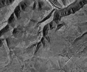
These were our guides to the area. On the air photos dark
patches of conifers could be seen on the upper slopes of the
y-shapes valley of upstream reaches of Lower Jerry Run. These were the trees
described by Dale and Ernie as old growth. Bruce Kershner also
had described limited hemlock old growth on a visit to the area.
This region is part of what is know as the Allegheny Plateau. It
is a broad general flat to lightly rolling plateau that covers
much of north and west central Pennsylvania. In this particular
area the cap rock of the ridges is a thick bedded sandstone
unit. Joints and pores within this sandstone unit allow water to
quickly seep downward resulting in a relatively dry upland
surface. Springs commonly emerge along hillsides and valley
walls where the downward percolating water reaches less
permeable layers of shale and siltstone.
Almost all of the area had been timbered in the late 1800's.
There is a nice description of the lumbering history of the
immediate area in a document entitled Elk State Forest.
http://www.pa-conservation.org/Elk-Forest.PDF
The virgin forest in Elk District consisted of magnificent white
pine, hemlock, some red pine, mixed oaks and northern hardwoods,
which included beech, sugar maple, birch, and black cherry. The
first timber removed from the [Elk State Forest] district was
the white pine used for ship masts. Some of the finest white
pine spar trees in the country were removed from Sterling Run
between 1865 and 1872. After white pine longs became scarce,
hemlock lumber prices rose high enough for the tanneries
formerly using only the bark, to begin marketing hemlock logs
for lumber. Sawmills and logging camps sprang up throughout the
district. Logs cut from the vast stands of hemlock were rafted
or floated down streams such as the First Fork, the Driftwood
Branch and the Bennett's Branch of the Sinnemahoning Creek. In
1915, the last log raft went down the Driftwood Branch, thus
ending the hemlock logging era. The cut-over areas were further
altered by vast wildfires that killed the remaining young trees.
With the exception of few virgin stands passed up by loggers,
the old growth forest in this area was gone. The first purchase
of land for the Elk State Forest was 3,487 acre tract in Middle
Jerry Run bought from D.R. Fullterton on May 31, 1900.
Originally called Forest Reservations, these lands were
purchased to reestablish a forest that had been nearly
eliminated by cutting and burning.
I did manage to find the Virgin Timber in the Lower
Jerry area. I found one tree that is about 10'
10" in circumference. There are a lot of of others
that are 8' and 9' in circumference. The trees are
about 8 tenths of a mile from the parking area. You can
drive to the power line and park if you have good ground
clearance. It is an easy walk following the trail, after
the snow goes away. - George Lockey |
We met at the entrance to the natural area. There is an easy to
find parking lot off Three Runs Road. There was a small American
Chestnut at the edge of the parking area twenty five feet high.
It looked like a good omen for the day. From the parking lot we
jumped into Anthony's jeep drove down a rough road running along
the western plateau above the run. The upper surface of the
plateau was forested with small relatively young trees. The
canopy reached 60 feet and consisted primarily of red maple with
white, chestnut, and red oak also forming portions of the
canopy. Scattered pitch pine reached 50 feet, Sassafras grew to
40 feet. The lower understory included smaller sassafras, maple
and oaks, and nice witch hazel up to 20 feet in height. The
forest floor was relatively open with scattered blueberry and
laurel and a covering of ferns woodland ferns just starting to
unfurl. The map showed an old road paralleling the stream valley
about ½ to the west. The idea was to drive down the road then
cut cross country to the east when we reached downstream as far
as the second small side branch. Here was an interesting looking
patch of dark blobs that could be old growth conifers.
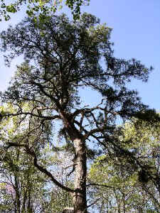 Pitch Pine on uplands
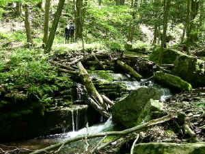
We followed the road until it ended at a camp. A blazed trail
led into the woods beyond the camp so we started hiking. After a
half mile or so it became apparent that this trail was leading
toward a small side stream draining to Upper Jerry Run to the
west. So we took a compass bearing and headed east. We were
bound to intersect Lower Jerry Run somewhere. On out hike we had
passed patches of blueberry bushes, most with only the beginning
of buds for the flowers that would eventually become
blueberries. Here however was a virtually impassible thicket of
mountain laurel. Most from chest height to over head high
entangled with downed branches and tree trunks. Anthony and I
took turns leading. We were forced to go northward as well as
eastward as we traveled. Eventually we reached the cover of
trees and escaped the thicket of laurel bushes. An old tree
stand or dilapidated structure of some sort reminded me of
something out of the Blair Witch Project.
Beyond the sheltering edge of the woods the land began to slope
downward. We walked downhill through some open woods and into a
hemlock thicket. Most of the hemlocks were small 6 to 8 inches
in diameter. A few were upward of 18' to 24" across and 60
to 70 feet tall. Nothing really impressive. They could be old,
but likely date from the 1880 to1915 period. Just below the
hemlocks was an old road. This was the one appearing on the topo
map. We followed the road down the hill deciding we were
descending into the valley of Middle Jerry Run. The hillsides
were very steep. As we descended the types of trees slowly
changed. We picked up some tuliptrees, ash, some birches.
Occasional massive blocks of sandstone were encountered along
the downward path. Small waterfalls and cascades could be seen
in the run far below. We descended to stream level near the
downstream end of the run.
As I crossed the stream at the bottom of the valley I slipped
and fell in the water, getting a wet and breaking my tripod. No
harm real done. The road continued on the eastern side of the
stream. We passed some open fields and circled around the bluff
separating Middle Jerry Run from lower Jerry Run past a camp on
private property along the lower edge of the natural area. The
road continued up Lower Jerry Run to another cabin in the woods.
Along this lower stretch of the stream were many sycamore, none
of them looked very old, but very nicely shaped, and a few
reached 100 to 120 feet in height. In the area we also found
basswood, beech, and yellow birch trees.

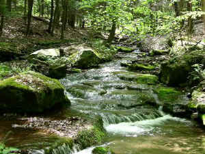
Lower Jerry Run is a pretty little stream. There are numerous
small cascades and waterfalls along its length. We walked up the
stream valley, crossing from side to side as the stream wandered
back and forth in the narrow valley. We clambered over rocks,
boulders and downed trees as we worked our way upstream. All
together a pretty fine walk in the cool shade near the cascading
streams. We could follow our progress on the air photo maps, I
even was able to get a GPS location at the one place we stopped
for a break, surprising in light of the narrowness of the valley
itself. We found a variety of microfauna - snails, millipedes,
centipedes, and caterpillers. Squirrels and chipmunks played in
the woods. Under one small hemlock was a pile of seeds from a
nearby tuliptree gathered by some enterprizing creature. Alas we
did not see any Elk. This is part of the Pennsylvania Elk Range
and Elk can be found in the area since their re-introduction
into the state several years ago.
We passed a couple of side branches with water and some without.
Toward the upper end of the stream we began to climb upward as
the stream cascaded down the steeper ground. The stream itself
at times occupied most of the valley bottom. My left leg was
hurting, I had twisted my knee when I fell in the stream, it
didn't really hurt much but kept cramping when I worked harder.
We looked at the maps and photos periodically, Anthony was doing
an excellent job of interpreting out location, however the
location was always farther downstream and lower in elevation
than I wanted it to be. At last we reached the upper major fork
of the Lower Jerry Run. The plan was to hike out the right hand
(going upstream) fork of the run to another cabin and then
follow the road back to the jeep. Anthony spotted an open area
up the steep side of the valley and what might be old hemlock
trees. He climbed straight up the side to investigate. After
sitting at the bottom for awhile and looking at the run ahead, I
felt it would be better to just climb the slope here and follow
along the level top to the cabin, rather than to deal with
stream, debris, rocks, and climbing following the stream itself.
I talked to Jacqui about it and started the steep climb out of
the valley. I stopped frequently on the slope, eventually reach
Anthony. He hollered forJacqui to climb up as well and I
continued upward to a less steep shoulder near the top. The
shoulder itself was likely because of a slightly softer rock
layer. Above this shoulder the hillside continued upward for a
distance before reaching the hilltop. However this slope and the
hilltop were covered by the same laurel thicket we encountered
on the hike in.
The trees Anthony had seen were hemlocks. They were not
impressive in size, but had a number of old growth
characteristics - furled bark, branching patterns. We talked
about it some, but thought they were small in size because of
the rocky nature of the ground and limited water that would have
been available to them at this location. There were a few other
old trees here some white oaks stand out in particular, not
large in size, but giving the appearance of age. This patch was
on the northern side of this fork of the run - not on the south
side were others had found old growth. So it
was a newly found patch of old growth. From the areas indicated
by Dale as being old growth, and what we found, it is possible,
or likely, that many of the dark blotches near the upper part of
these valleys are patches of old growth hemlock, and maybe some
white pine. Further trips will be necessary to explore all of
these features.
From here we hiked along the slope toward the cabin. I was
forced to stop multiple time because of cramping in my knee. I
must apologize to my hiking companions. This was fairly level,
with only a little up and down to avoid patches of laurel. Even
with my leg problems I think this was easier than it would have
been hiking up the stream bottom beyond the fork. Besides we got
to see some of the old growth hemlock. We soon reached the camp
and started up the road toward the vehicles. I had to stop again
several times because of cramps in my knee. Tony and Jacqui
suggested going and getting the jeep and picking me up. I
agreed, After they left I drank the rest of my
refreshments and rested for another ten minutes or so. I hiked
out to the main dirt road and waited fro them there, exploring
the ridge-top forest while I waited.
Overall we hiked perhaps 5 miles, we started at an elevation of
2089 and dropped down to 880 and back up again. It was a good
trip overall. We hiked the length of the natural area, We found
some old-growth, with potential for more. The stream with the
cascades and waterfalls was beautiful. I took some nice photos.
I was disappointed that I don't have pictures of the hemlocks. I
was hurting at the time and just didn't think to take any. I
expect I will be back again later this summer.
Edward Frank
|