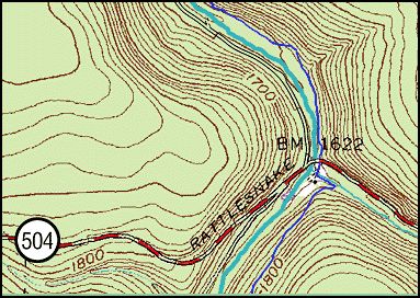
Monday, May 18, 2009: I took a short hike of perhaps a mile
and a half (one way) along the Allegheny Front Trail heading
south from where the trail crosses Route 504 at the Six Mile
Run. The Allegheny Front Trail runs a total distance of 40
miles generally north and south through the Moshannon State
Forest.
I became curious about this small stretch of the trail after
reading trip report by Gary Thornbloom of the Moshannon Chapter
of the Sierra Club. In talking about a hike along the AFT he
wrote:
Large rhododendron and hemlocks
form a canopy over the path. Here the trail uses two
sections of old logging railroad grades. According to Ralph
Seeley in Greate Buffaloe Swamp this small grove of hemlock
giants survived only because they were along a disputed
property boundary. The penalty for cutting your neighbors
trees was quite severe. This resulted in numerous stands of
trees not being cut and we now have many small glimpses of
the forest that once was. The AFT soon comes out on Route
504.
http://pennsylvania.sierraclub.org/moshannon/OTT/OTT04-5AlleghenyFrontTrail.htm
This section
of Pennsylvania had once been covered with thick forest, but was
extensively logged in the latter part of the 19th century and
early 20th century. A history of the Moshannon State Forest
http://www.dcnr.state.pa.us/Forestry/stateforests/moshhistory.aspx describes
what once was present: "White pine and hemlock stands
occupied the shady slopes and moist plateaus in the earliest
recorded forests in the region. Many areas were covered with a
mixture of beech, yellow poplar, birches, maples, oaks, cherry,
hickory and chestnut. Some of the best white pine in the U.S.
grew here in the stands that sometimes approached one hundred
thousand board feet per acre. According to Conrad Weiser in
1737, "The wood is so thick, that for a mile at a time we could
not find a place the size of a hand, where the sunshine would
penetrate, even on the clearest day."
"All of this
virgin timber was cut between 1860 and 1921. The high pine
stumps, the tie marks from the logging railroads, the grooves of
old log slides and the remnants of splash dams are all that
remains to remind us of this earlier time of
overcutting. Wildfires, which followed this period of cutting,
many of which were caused by man, destroyed much of the humus
and organic matter that had taken nature centuries to create.
Even today, there are open areas where mainly bracken fern and
huckleberry grow among the giant stumps of a former forest that
remind us of the devastation caused by those fires. The forest
that developed after the periods of overcutting and wildfires
was predominately oak-chestnut. Prior to 1925 the chestnut
blight swept through the region. The present-day oak-hardwood
forests is a result of the loss of the chestnut component due to
the ravages of the blight."
The harshness
of the logging effectively denuded almost all of this region of
Pennsylvania. The result of this and the fires that
followed can still be seen in the poorly growing forests in the
flats above Lower Jerry Run and at Marion Brooks Natural Area
that I have reported about previously, So here was a
chance to see a small patch that might have survived in the
midst of the logged area. To tell the truth I was not that
optimistic that I would find much of anything here.

The trail
starts on the east side of a of a bridge on Route 504 where it
crosses Six Mile Run. It crosses a short plank bridge over
a side stream and immediately jogs left to bypass an A-Frame
camp and heads up the hill and then after a gain of a 100 feet
of elevation or so it turns right to parallel and follow Six
Mile Run upstream. This level path follows along the base
of a scree slope and is overhung by large Great Rhododendron
bushes. After a short distance the trail drops back down
to stream level and continues to follow the run upstream.
The trail after a short distance rises over a shallow prong and
again drops to the stream level. it is here that the small
remnant of older trees is found. There aren't many of
them. There are six to eight large hemlock trees growing
in a flat area a hundred feet wide along the stream. The
area is dissected by old stream channels and is generally
populated by Great Rhododendron, many smaller hemlock trees,
yellow birch, and scattered other species.

The larger
hemlocks are all under a hundred feet tall and 8 to 10 feet in
girth. The largest hemlock was 95.1 feet tall and 9' 5" in
girth. Another one nearby likely would have been taller,
but its top had broken out and the tree was dying. These
would not even be notable in a place like Cook Forest with
hundreds of large hemlocks, but here among the smaller trees
they really stood out. There was a distinct jump in size
between these individuals and the many smaller hemlocks in the
area which leads me to believe these are a small remnant pocket
from the pre-logging era.
|
Name |
Species |
Height (ft) |
Girth (ft. in.) |
|
Hemlock |
Tsuga canadiensis |
95.1 |
9' 5" |
|
White Oak |
Quercus alba |
75.5 |
5' 2" |
|
Red Maple |
Acer rubrum |
75 |
3' 6" |
|
White Pine |
Pinus strobus |
71.2 |
9' 9" |
|
White Ash |
Faxinus americana |
64 |
2' 7" |
|
Black Cherry |
Prunus serotina |
60 |
2'
11.5" |
|
Yellow Birch |
Betula alleghaniesis |
61.8 |
3' 7" |
|
American Beech |
Fagus grandifolia |
63 |
5' 7" |
|
Pitch Pine |
Pinus resinosa |
57.2 |
4' 6.5" |
|
Red Oak |
Quercus rubra |
~60 |
|
|
|
RHI 10 |
68.28 |
|
|
|
|
|
|
|
Great Rhododendron |
Rhododendron maximum |
9 |
1' 1" |
|
|
|
|
|
I am not sure
why there are large older hemlock trees and no large specimens
of any other species. The only other fat tree in the area
is a white pine, a wolf tree, short and squat at the upper end
of the flat. It had numerous branches extending all the
way to the ground. The above Rucker Index is a very low
one. I measured a red oak at 60 feet but did not write it
down, The pitch pine is farther back on the trail toward
504.
Beyond this
flat area the trail climbs and turns to the left up a side
valley and eventually leads to the hilltop above. I
followed this trail perhaps half way to the top and stopped in a
cool patch of Norway spruce and European larch. What was
interesting to me was that much of this section of the trail
crossed a scree slope. I am using this to refer to a slope
of generally loose flat stones from cobble to flagstone sized on
a comparatively steep slope. These are formed by frost
wedging of a sandstone bedrock outcrop farther up the slope.
These ones in particular likely are periglacial in orign and
date from the last ice age. Most interesting is the
assemblage of plants growing on these slopes. The soil is
often buried to some depth by the rock scree. the scree is
slowly moving down the slope. water immediately sinks into
the rock mass and is not available for plants growing on the
rock surface if they do not have long roots. The history
description described a land surface after the fires that grew
huckleberry and bracken fern. Those were the
predominant small plants growing on the scree surface, but I am
not sure this is a result of fire. I have no reason to
think that this are was every heavily forested and that if it
had been logged that there would have been enough logging debris
to support any type of massive fire. There are some small
trees sprouting in the rock slope, generally yellow birch and
hemlock, with scattered black cherry, red maple, oak, and white
pine. There are clumps of rhododendron.

For the most
part much of the scree surface is fairly open. Those pine
and hemlock trees present are squat in form and the green
branches extend all the way to the ground. I don't really know
how old any of these trees are without any core data, but some
of them could predate the logging operations. Even if the
individual trees are not that old, this type of forest could
represent an old growth dynamic system.
|
Name |
Species |
Height (ft) |
Girth (ft. in.) |
|
European Larch |
|
82.6 |
3' 7.5" |
|
White Pine |
Pinus strobus |
80.7 |
8' |
|
Hemlock |
Tsuga canadiensis |
59.5 |
5' 7" |
Where trees
are present their leaf litter allows for some soil formation
atop the loose rocks. These form little islands of plant
growth among the rocks. I looked at fairly large areas
of short oak forests atop the blue ridge in Virginia in
Shenandoah National Park not shown on any maps.This was
evidenced by ring counts of some of the downed trees along the
road. Bob Leverett commented on this also. there are
the old post oak ecosystem in the cross-timbers area of south
central US. Neil Pederson found old chinquapin oak trees
unrecognized in the heart of Kentucky. We know about the
extremely dwarfed fairy-like forest atop Mt. Everett in MA.
I wonder how many areas actually have old growth forests or
systems that we do not recognize. We commonly look for
massive towering trees when we think of old growth. We
recognize the very dwarfed forest like are atop Mt. Everett.
We note the gnarled cedars in the Niagara Gorge. But how
many places are there where there are old forests, or old forest
systems where the trees are growing in generally poor
conditions? perhaps they were not logged because of the
poor quality of the wood, or because of the the terrain upon
which they are growing. If they are not gigantic in size,
or extremely dwarfed and gnarled, perhaps we are simply not
noticing them? How many poor looking, moderately stunted,
old forests are growing places that we simply have not noticed?
I don't know if this is an old system or not, but it could be.
Edward Frank