| Waterfall
Creek/Carter Creek, NC |
Jess
Riddle |
| Sep
27, 2006 18:58 PDT |
Ents,
The Craggy Mountains provide a dramatic backdrop to Asheville,
North
Carolina rising to over 6000' elevation. The rugged peaks appear
to
gradually blend into the rugged peaks of the Black Mountains,
which
contain the highest peak east of the Mississippi (Mount
Mitchell,
6684'), but they contrast strongly in geology. The gneiss and
metagreywacke of the Black Mountains weather to produce acidic
soils
that support extensive stands of red spruce with dense tangles
of
rhododendron underneath. Contrasting, the richer soils of Craggy
Mountains give spruce only limited range and thick herbs layers
fill
more of the understory than rhododendron. Since spruce does not
dominate all of the high elevations, stunted, gnarled forests of
beech, yellow birch, and mountain ash cover the range's high,
windswept ridges and peaks helping to give the mountains their
name.

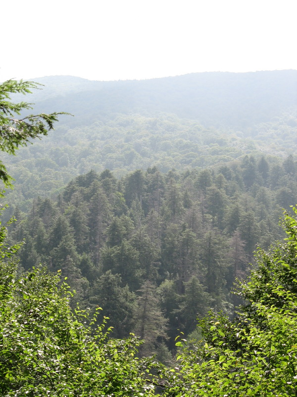
Uncut forest heavily dominated by eastern hemlock above
Douglas Falls in the Waterfall Creek watershed.
A survey of the Craggies for old-growth conducted by Alan Smith
in
1998 determined the Waterfall Creek/Fork Ridge/Upper Mineral
Creek
stand to be the largest remaining tract of uncut forest in the
range.
The stand's 1577 acres of reported old-growth span half a
vertical
mile to the top of Craggy Dome (6080'). Stunted northern
hardwood
forests and extensive beech gaps persist in the harsh climate of
higher parts of the stand. Below them, the yellow birch become
increasingly large until a broad band of hemlocks is encountered
at
about 4600'. Within the swath of hemlocks, patches of hardwood
forest
with large sugar maples and diverse herb layers occupy the
gentler
topography. Diverse hardwood forests with more southern species
like
tuliptree grow along the streams at the lower edge of the stand.
To reach the stand, we drove up an idyllic mountain valley with
broad
fields and stone buildings. At the end of the valley, a Forest
Service road winds for miles across the slopes and past the
better
known old-growth of Walker Cove Research Natural Area before
ending at
the Douglas Falls Trailhead. The trail immediately plunges into
old-growth, and traverses a slope covered with old mixed oak
forest.
The herbaceous layer along the trail includes the uncommon
Coreopsis
latifolia, woodland sunflowers, and several other species. As
the
trail approaches the Douglas Falls, large hemlocks and sugar
maples
form the canopy over witch-hobble, wood fern, and partridge
berry.
Above the falls, the trail continues winding through successive
groves
of sugar maple, hemlock, yellow birch, and beech, and eventually
ends
on the Blue Ridge parkway.
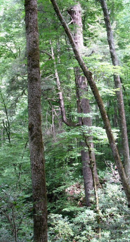
Our path diverged from the trail at the falls. We crossed a
rhododendron covered slope and descended an open cove to the
boulder
strewn Waterfall Creek. On the far side of the stream, 4600'
high
Sprucepine Ridge rises up sharply, covered with large hemlocks
and
rhododendron except for a few expanses of bare rock. Josh
pointed out
that in the Craggies, rhododendron tends to only grow in areas
with
thin soils. We weaved our way between the outcrops, and grabbed
onto
rhododendron and dog-hobble to haul ourselves up to the more
gentle
upper slopes of the ridge. Those slopes were a pleasant change
with
deeper soils, few rhododendron, and sugar maples, basswoods,
northern
red oaks and cherries mixing in amongst the hemlocks, and the
rare
orchid, Goodyera repens, was flowering in several locations. The
hemlocks themselves were a welcome change from most of the
southern
Appalachians; while a few areas had undergone noticeable decline
from
the adelgid, most of the hemlocks remain a thick, lush green;
however,
adelgid populations are heavy, so the real damage is about to
begin.
On the far side of the ridge, we descended an open slope only
about
100' to reach the headwaters of Carter Creek. Buckeye, basswood,
and
clumps of Beech rose out of thick, rocky beds of stinging
nettle.
Farther down the stream, yellow birch, white ash, black cherry
sugar
maple and bitternut hickory also mixed into the canopy. None of
those
species reached especially large sizes, so we veered up to the
low
ridge separating Carter Creek from Bearwallow Branch. Bearwallow
Branch has more gentle topography than Carter Creek, and was
apparently more productive. Hence, loggers focused more on the
smaller stream. We saw clear evidence of logging on the edge of
the
watershed in the general lack of old trees and the cut American
chestnut stumps.
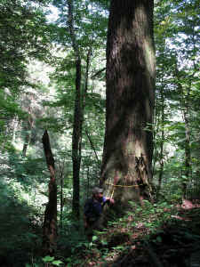
Large hemlock on Carter Creek. 15'4.5" cbh and 143.0' tall.
Since the ridge appeared to hold little promise, we steered back
down
towards Carter Creek, and on the way passed a small rock outcrop
with
the rare climbing fumitory, an herbaceous vine with flowers and
foliage resembling squirrel-corn. Back at the stream, by far the
largest hemlock we had seen all day immediately greeted us. The
tree
stood on a steep slope about 25' above where the stream sheeted
across
bedrock. No shrubs obscured the view of the tree's massive trunk
that
rose above surrounding smaller hemlocks, basswoods, and beech to
a
height of 143.0'. However, more than the height, the slow taper
above
the 15'4.5" cbh made the tree impressive. The total volume
is
certainly over 1000 cubic feet and probably exceeds 1100 cubic
feet;
greater than any other hemlock ENTS has found in limited
searching
east of the Smokies.
Hoping to find other equally impressive trees since we were
still at
approximately 3800' elevation, we continued down Carter Creek,
but
quickly encountered badly eroded remnants of an old logging
road. The
road probably explained the lack of large individuals of
commercially
valuable species farther upstream. We also started seeing
tuliptrees,
all of them young, further indication of high-grading along the
stream. The tuliptrees also indicated a slightly milder climate
that
was mirrored by the herbaceous layer with more hepatica, yellow
mandarin, blue cohosh, black cohosh, and other rich site species
mixing in with the nettles. Fungal diversity also increased as
we
proceeded downstream, and we stopped to collect a few oyster
mushrooms
and chicken mushrooms for later consumption.

The large hemlock on Carter Creek near the confluence with
Waterfall Creek. 17'4" circumference, 147.4' tall.
Near the confluence of Carter Creek with Waterfall Creek, we
again
stopped to look at a hemlock that stood out from the rest. This
tree
stood on an extremely steep bank between a small stream-side
flat and
a level bench, all covered by much younger and smaller trees.
The
dog-hobble around the tree's base posed less of a challenge to
measuring than the 9.4' elevation difference between the high
and low
sides of the tree. That grade put the lowest measurable
circumference
5.1' above midslope, which came out to a whopping 17'4".
Above the
influence of root flair, at 9.1' above midslope, the
circumference was
a still impressive 14'10". The trunk gradually tapers as it
ascends
to a shrub-like top 147.4' above the base. The larger base but
faster
taper made the tree appear only slightly smaller than the
hemlock that
had stopped us farther upstream.
Leaving that hemlock, we crossed the bench to Waterfall Creek,
and
quickly encountered more old trees. However, again the remnants
of a
road paralleled the stream and suggested selective cutting. The
steep
slopes along the stream supported more rhododendron than Carter
Creek,
but strips of rich forest with open understories and diverse
herbs
still permitted us easy passage. Rock stonecrop and
plantain-leaved
sedge were more common in these woods, but the more acidic
slopes
still held the largest hemlocks, including a third giant
15'0" cbh x
145.1'.
Shortly upstream of that hemlock and downstream of a
boulderfield, the
old roadbed ended. Above that point, we saw no evidence of past
logging, and started encountering larger hardwoods. Among those,
tuliptree reached 14' 2" cbh and northern red oaks reached
16'0" cbh,
the red oak the second largest reported from the mountain range.
However, the rich forest with those large trees again gave way
to
smaller birches and rhododendron thickets as the soils thinned
and the
stream approached its large namesake cascade. Eventually, the
rhododendron thickets gave way to expanses of bare rock, and we
picked
our way upstream at the base of the cliffs. Not wanting to have
to
negotiate the cascades and having completed almost a full loop,
we
hiked up the slopes skirting a couple more rock outcrops and
climbed
over one small rock ledge to get out of the Waterfall Creek
gorge.
Upon scrambling over the ledge, we immediately met a 15'7"
cbh
tuliptree that bested the mountain range girth record just set
down in
the gorge. Making the tree even more surprising, it grew at
about
4200' elevation, above the normal range for tuliptree, and
obviously
had limited soil. However, the slope above did appear to have
deeper
soil with striped maples and witch-hobble replacing rhododendron
and
large hemlocks forming most of the canopy. We stopped briefly to
collect more oyster mushrooms and admire a relatively healthy
American
chestnut, but quickly covered the short distance back to the
trail and
the car pleased with our day in the woods.
Jess Riddle & Josh Kelly
|
| RE:
Waterfall Creek/Carter Creek, NC |
Robert
Leverett |
| Sep
28, 2006 05:43 PDT |
Jess and Josh,
Congratulations! What a trip and what a trip report! I have
visited
part of the watershed that you describe on 4 different occasions
and can
attest to its magnificence, but you've bested the best that I
saw. That
region was the site of an intense environmental battle in the
early to
mid-1990s with the Forest Service and the work of a dozen or so
top
scientists-environmentalists-naturalists-activists continues to
point to
the necessity for independent watchdog groups over government
agencies.
The Forest Service has come a long way since
the days of timber
quotas. From what I'm seeing, today, the Forest Service has some
extraordinarily well-managed forests. I hope the Pisgah and
Nantahala
are now among them. What is your take on that? What kind of
impact do
the local environmental groups have in the southern Appalachians
these
days - given the policies of the current administration in
Washington?
Don't want to put anyone on the spot. Just wondering.
Bob
|
| RE:
Waterfall Creek/Carter Creek, NC NF Management |
Joshua
Kelly |
| Sep
28, 2006 14:29 PDT |
Bob,
In regards to your questions about the management of the Pisgah/Nantahala:
it's a mixed bag. Overall, things are much better than they were
during the
80's and early 90's. No huge road building projects, logging a
fraction of
what it was then - over 60 million board feet some years. Yet in
the past
six years, logging has increased dramatically, and last year 16
acres of a
state designated heritage preserve were logged down to 15 basal
area. Some
districts are logging about 500 acres yearly, prioritizing the
most
productive rich cove and projects that rebuild and maintain the
huge
roadsystems built in the 80's, many of which were put into areas
that were
recognized as roadless by RARE II in the late 70's. I guess
that's what you
would expect though, when a former timber company lobbyist (Mark
Ray), and a
former Boise-Cascade executive (Dale Bosworth) are put in charge
of the USDA
and USFS, respectively. Yes, the foxes are in the hen house,
again (I'm not
sure they ever leave).
The half-dozen or more environmental groups operating in the
Southern Blue
Ridge do get a spot at the negotiating table with the FS, often
because of
prior, successful legal challenges. In my view, cooperation is
the preferred
method of getting through, but litigation is a valuable option
to have. I
realize that the major problems with the FS come from high up in
the agency
and with our lawmakers. Those are the folks I have bones to pick
with. I
mostly try to be helpful to the local personel, and also to
those outside
the agency who are able to apply some pressure when needed. I
reckon' I'm a
double agent or something. If you or others are interested, I
can keep
folks updated about the management activities in the Pisgah/Nantahala.
It
would be great if some of the knowledgeable ENTS would comment
on proposed
logging projects.
Kind regards,
Josh
|
| RE:
Waterfall Creek/Carter Creek, NC NF Management |
Joshua
Kelly |
|
Sep
29, 2006 06:56 PDT |
Bob,
An accurate RHI for the Craggies/Blacks would be great, and that
30+ K swath
of National Forest is among the most important in the entire
U.S. from a
natural history perspective, and faces little threat from
logging because of
it. Other areas, like the east slope of the Nantahalas, are
equally
notable, yet lack a few important components to be well managed:
public
oversight, scientific attention, and Spruce-Fir Forest. What the
Nantahalas
do have are the best known examples of Montane Cedar-Hardwood
Woodlands, and
mesic forests over calcareous and mafic rock greater densities
than on other
public lands in the Southern Blue Ridge. As I have proposed
before, I think
it would be great if every montane range, or better yet, every
watershed in
the Blue Ridge had a solid RHI, and the most outstanding extant
forests were
identified and tracked by ENTS. I think that would be a very
cool section
of the website. Although ENTS is not an activist website, I too
celebrate
the recent protections for the most significant forests at
Mohawk Trail and
hope that a similar feat can be accomplished, on a larger scale,
in the
Southern Blue Ridge.
Cordially,
Josh
| |
From:
Robert Leverett
Subject: RE: Waterfall Creek/Carter Creek, NC NF
Management
Date: Fri, 29 Sep 2006 12:38:02 +0000
Josh,
Thanks for the report. While
ENTS is definitely not an activist
organization, what we can do is help confirm rare and
exemplary areas of
forest. That is one of our most valuable services we can
provide. It has
made a significant difference in Massachusetts in terms
of MTSF being
recognized as the exemplary place that it is. I realize
that there are
many top notch scientists and naturalists that work in
the Craggies, but
maybe we can add something - at least in documenting
tree dimensions,
Rucker indices, etc. It sounds to me like that drainage
needs to have
its own RHI computed.
Bob
|
|
| RE:
Waterfall Creek/Carter Creek, NC NF Management |
Robert
Leverett |
| Sep
29, 2006 12:45 PDT |
Josh,
Relatively few tree-savy people fully
appreciate just what a prolific growing machine the southern
Appalachains are. We need a lot more data before drawing
definitively
conclusions about what each eastern species can do at its best
and where
it achieves that best. However, when it comes to height, the
southern
Apps seem to create a climax environment for a at least a couple
dozen
species, maybe many more. But our coverage of the southern Apps
is still
very thin. Will, Jess, and Mike are stretched to the thickness
of dental
floss now. What is the possibility of organizing a group serious
about
collecting data and computing RHIs? We certainly can provide the
training.
Bob
|
|