Ents,
I spent a day on each of two recent weekends hiking the trails
in
Pisgah National Forest's Middle Prong Wilderness Area. The
wilderness
lies adjacent to the better known Shining Rock Wilderness Area
and the
southernmost section of the Blue Ridge Parkway in North
Carolina. The
two fires that burned large areas in Shining Rock early in the
1900's
had much less impact in Middle Prong Wilderness. Consequently,
Middle
Prong lacks the large grass and shrub balds that dominate the
high
elevations in shining rock, but still has smaller meadow-like
openings
in the forest. The fires started during logging operations that
denuded most of the area now set aside as wilderness, so only
scattered pockets of old-growth forest remain.
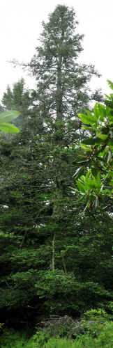
6.1' cbh x 64.8' tall Fraser fir on Mount Hardy
photo by Jess Riddle
Elevations within the Middle Prong Wilderness range from 3200',
where
the stream exits the wilderness, to 6410', on top of Richland
Balsam.
Forest communities change along with the elevations; dense
stands of
tuliptree dominate at low elevations, but tuliptrees are absent
from
the stream-sides by 4000'. At those elevations, an open
understory
forest dominated by red maple, black birch, yellow birch, and
smaller
numbers of other hardwoods cover the moist slopes. Going
upstream,
hemlock, yellow birch, serviceberry, and rosebay rhododendron
gain in
importance at the expense of the other hardwood species. The
hemlocks
eventually give way to red spruce, which dominate the high
elevations
except for a few Fraser Fir stands and beech covered slopes.
Those
beech forests are now rapidly declining as beech bark disease
passes
through the area.
Species Cbh Height
Blueberry, Constables? 0.91' NA
Fir, Fraser 4.78' 53.2'
Fir, Fraser 3.88' 56.8'
Fir, Fraser 3.60' 58.7'
Fir, Fraser 3.68' 60.2'
Fir, Fraser 4.62' 60.5'
Fir, Fraser 3.30' 60.6'
Fir, Fraser 6.10' 64.8'
Maple, Mountain
2.40' 42.4'
Maple, Striped
3.13' NA
Maple, Striped
3.24' NA
Mountain Ash
4.47' NA
Mountain Ash
3.25' 53.5'
Rhododendron, Catawba 0.88' 20.1'
Silverbell
10.22'
~77'
Spruce, Red
8.85' 113.6'
At high elevations and outside of the dense spruce and beech
groves,
blueberries frequently reach half a foot cbh and 12' tall. At
1.3'
above the ground, below the first fork, the blueberry listed
above is
1.38' in circumference.
Base of 6.1' cbh x 64.8' tall Fraser fir
Previously, ENTS had only measured Fraser fir on a few high
peaks in
the Smokies and Black Mountains and a few planted trees. The
tallest
of those trees was 55'. The trees listed above grow in a
somewhat
milder climate between 5300' and 5700' elevation, and as
scattered
trees rather than in pure fir groves. Some smaller Fraser firs
in the
area have ongoing infestations of balsam woolly adelgid, but the
adelgids are not yet attacking the trees listed above. Most of
them
still have fairly smooth bark, but the largest already has many
fissures in the bark.

Mountain Maple 2.4' cbh x 42.4' tall
photo by Jess Riddle
The mountain maple qualifies as a state co-champion and ties the
height record for the species.
The silverbell might not be noticed in the Smokies, but may be a
circumference record for the species outside of the Smokies.
All of the above trees grow within sight of trails. The area
must
have many mores trees of interest hiding away from the trails in
the
tangles of rhododendron.
Jess Riddle
|


