|
Hi All,
In 1892, the New York State legislature established the Adirondack
Park, which now encompasses nearly six million acres and occupies
most
of northern New York.
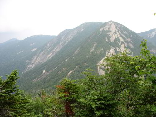
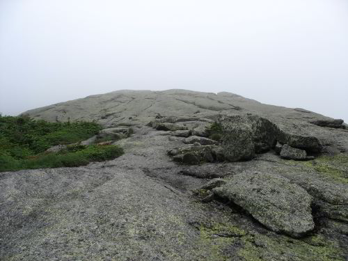
Gothics. The Great Range Trail is visible as thread of
exposed rock on the ridge in the center of the photograph.
The park includes approximately 2.5
million
acres of Forest Preserve, designated "forever wild", and
most of the
Adirondack Mountains, a still rising section of the Canadian Shield
(http://www.apa.state.ny.us/About_park/index.html).
The low relief of
the mountain range's southern and western sections, often just a few
hundred feet, gives little indication of the High Peaks region's
ruggedness. There, streams cascade through gorges, sheer
cliffs
plunge into glacial lakes, the peaks extend up into climates too
harsh
for trees, and landslides and avalanches scar the slopes.
Those
features combined with the close proximity to New York City have
made
the region a mecca for outdoor recreationists, and lead to the
development of an extensive trail network.

A typical steep stretch of the Great Range Trail
Lee Davis, another grad student at SUNY-ESF, and I recently took a
three day trip through the heart of the region focusing on the
higher
peaks. We started at slightly over 2000' elevation in the flat
lands
south of Lake Placid, and briefly passed through an old red pine
plantation with wild sarsaparilla dominated herb layer.
However,
following a small stream towards the larger mountains we soon
reached
a gentle, north-facing slope where the logging operations of the
late
1800's appeared to have removed only red spruce, which along with
white pine was the most prized timber species of the time.
Sugar
maples, some approaching three feet in diameter, formed most of the
overstory along with beech, most of the larger ones showing damage
from beech bark disease, and yellow birch. Sugar maple also
dominated
the understory although striped maple and beech sprouts were also
common.

Mount Colden behind Marcy Dam Pond. |
Passing through a shallow gap brought us to the slopes
surrounding Marcy Dam where more intense logging activity had
dramatically altered the forest's composition. The dense
canopy
comprised paper birch and balsam fir, except along the stream banks
where yellow birch and mountain ash added diversity. In that
forest,
paper birch saplings were rare, but balsam fir and red spruce formed
a
well developed understory over bunchberry, goldthread, starflower,
and
whorled wood aster.

An opening in the balsam fir forest next to Lake Tear of
the Clouds at approximately 4300' elevation.
Bunchberry blooms in the lower right, and the large leaves
just above them belong to hellebore. |
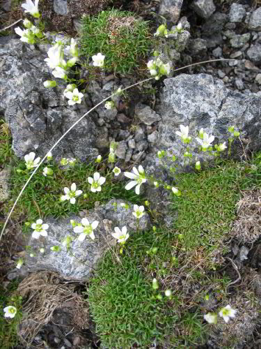
Mountain sandwort, one of the common species in the alpine
zone. |
We ascended from Marcy Dam towards Avalanche Pass, our gateway to
the
interior of the High Peaks region. Unlike the nearby Green
Mountains
or the higher ranges of the southern Appalachians, each of which
consists of essentially one large, undulating ridge with descending
spur ridges, the High Peaks region contains several distinct
northeast-southwest oriented ridges with occasional cross-linking
ridges, more like New Hampshire's White Mountains. Avalanche
Pass
separates the McIntyre Range with Algonquin Peak, the second highest
peak in NY at 5114', from the Great Range with Mount Marcy, the
highest mountain in NY at 5344'. At the pass, we also left
behind the
signs of past logging disturbance, but the forest was far from
undisturbed. In 1999 several acres of forest and soil on one
side of
the pass slipped off the mountain side and piled small paper birch
and
conifer trunks over ten feet high in the pass. On either side
of the
landslide's base, northern white cedar cling to low cliffs and red
spruce, balsam fir, and paper birch dominate the surrounding forest.
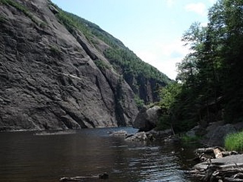
Avalanche Lake. Photograph by Lee Davis |

Meadow rue blooming beside Avalanche Lake. |
Continuing through the pass brought us to the larger expanses of
rock
bordering Avalanche Lake where a 200' high rock wall rises directly
out of the lake. The trail weaves around the lake by
traversing the
forested talus slope that separates the opposite shore from the
higher
cliffs of Avalanche Mountain. The more tame upper and lower
margins
of the lake provided open habitat for white meadowsweet, leatherleaf,
meadow rue, sedges and grasses.
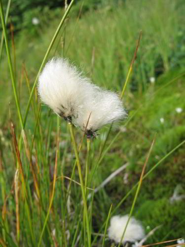
Eriophorum vaginatum var spissum: Cotton sedge thrives
around the
edges of high elevation bogs.
After reentering the forest at the downstream end of Avalanche Lake,
species composition varied little as we followed a small stream to
Lake Colden, skirted the edge of the lake, and gained elevation
along
the upper reaches of the Opalescent River. Bunchberry, whorled
wood
aster, northern beech fern and many bryophytes also thrived in the
shade provided by balsam fir and smaller numbers of red spruce,
paper
birch, and near the waterways, northern white cedar.

Opalescent River: Rapids on the upper reaches of the
Opalescent River.
The
Opalescent
River cascades over and sluices through highly fractured
bedrock,
and
the rock exposed along its edges provides the cedars with
habitat
sharing many features with that of the cliff dwelling cedars seen
around Avalanche Lake. However, cedars also grow at a short
distance
from the river and along smaller streams not on bedrock. At
around
3300' elevation, the gradient of the Opalescent River drops
dramatically, the water courses around boulders rather than bedrock,
and white cedar vanishes from the banks. Instead, mountain ash
and
shrubs including a viburnum, alder, Bartram's serviceberry, and
round-leaved dogwood grow scattered along the stream bank amongst
the
three dominant tree species: balsam fir, red spruce, and paper
birch.
In that upper hanging valley, draining the slopes of Mount
Colden and
Mount Marcy, most of the mature individuals of those canopy species
had died within recent decades leaving a dense regenerating forest
of
saplings.

Rhizocarpon geographicum: The yellow crustose lichen
is Rhizocarpon
geographicum, one of the dominant species in the alpine zone. |

Saddleback with multiple avalanche scars visible on the
right side. |
Above the relatively sheltered slopes along the upper Opalescent
River, wind and cold take their toll on both forest diversity and
forest stature. By 4300' elevation, trees over 40' tall were
scarce,
as was red spruce, and paper birch persisted only as scattered small
individuals. The climate and balsam fir canopy favored
bunchberry,
bryophytes, and to a less extent northern beech fern. As we
continued
toward the top of Mount Marcy, the canopy height gradually declined
to
about 15', but the firs remained straight.
The alpine zone on top of Mount Marcy. |
Krummholz on Mount Marcy. |
That stunted forest
transitioned on the upper side into krummholz, the twisted
and
dwarfed
community produced where harsh alpine conditions approach
the limits
of trees' tolerances. The krummholz's dense canopy formed
primarily
from interlocking branches of balsam firs less than five feet tall,
but spruce, probably black spruce, dominated some patches and resin
birch, paper birch, and mountain ash, probably showy mountain ash,
grew scattered amongst the conifers. On the summit of Mount
Marcy,
the severe conditions forced the krummholz to give way to an alpine
community, home to many species rare in the state. Most of the
community consisted of crustose lichens, especially Rhizocarpon
geographicum, covering the bare, windswept rock of the summit, but
plants could survive where boulders or rock ledges provided shelter
or
crevices allowed soil to accumulate. Most of the alpine plants
are
fairly unobtrusive since they adopt low, compact growth forms to
stay
close to the relatively warm ground and minimize wind exposure, but
Mountain sandwort and three toothed cinquefoil's flowers made them
conspicuous as we traversed the summit. Labrador tea, white
meadowsweet, and bog laurel, all species also occurring in wetlands,
also flowered in the interface between the krummholz and the alpine
zone, an area that also provided habitat for several shrubs
restricted
to the mountaintops.
The edge of a rock outcrop
From the summit of Marcy, we followed trails along the crest of the
Great Range and away from the steady stream of people intent on
reaching the state's highest point. The popularity of the
trails, the
easily eroded soils, and routing of trails straight up and down the
slopes have combined to reduce sections of trail to a series of
boulders; hence, hiking the trails often involves much more rock
hopping than walking. On the steepest peaks, the trails also
include
stretches on bedrock inclined up to 45 degrees (100%) to take hikers
form the deep gaps back up to the peaks. The peaks' rock
outcrops and
stunted vegetation permit broad views of the surrounding mountains
and
glimpses of the lakes nestled between them. Most of the higher
summits feature large areas of exposed light colored rock running
down
their slopes that contrast with the dark green of the surrounding
conifer forest. On a few peaks, long linear vegetated but not
forested streaks extend down from the rock outcrops, probably scars
from avalanches. On the forested slopes, the dominance of
balsam fir
is apparent in the sea of well-formed conical crowns pierced only by
scattered red spruce and interrupted by the lighter green domes of
paper birch.

A Cladonia and a darker unidentified lichen intermingle on
the edge of the
krummholz zone.
We started passing under more spruce and paper birch crowns as we
left
the spine of the Great Range and descended along Wolf Jaw Branch.
Many of the paper birch appeared fairly young, but the forest still
contained relatively large red spruce, around two feet dbh, that
would
have been targeted by loggers. Yellow birch were shorter than
the
spruce, but reached larger diameters, especially on broad gentle
slopes, which also supported the largest balsam firs we saw, around
75' tall. The lower canopy layers also changed as we reached
more
productive gentle topography with thickets of conifer saplings and
large colonies of bunchberry giving way to a sparser mix of conifer
saplings and striped maple and a thick layer of wood fern or
mountain
wood fern. As we continued down into warmer climates, conifer
abundance declined and sugar maple and yellow birch became the
dominant species; the latter were among the largest trees we saw on
the trip with diameters approaching three feet. Conifers
returned to
dominance after we crossed Johns Brook and began ascending Black
Brook
towards Klondike Notch, but yellow birch remained a major canopy
component and quaking aspen occurred in scattered groves.
Second growth paper birch dominated forest along Klondike Brook.
The forest changed dramatically after we passed through the notch.
Gentle topography, relatively productive soils, and easy access from
the flat lands south of Lake Placid, made the Klondike Brook
watershed
an obvious target for early logging operation. The disturbance
produced an opportunity for balsam fir and paper birch to dominate
the
west facing slopes at the upper end of the watershed and for paper
birch and smaller numbers of yellow birch to dominate most of the
gentle northeast facing slopes farther down the drainage.
Mountain
maple and striped maple form a relatively dense understory beneath
the
birches and either intermediate woodfern or mountain woodfern hide
the
forest floor. However, scattered herbs characteristic of
richer site
including red baneberry, rosy twisted stalk, and plantain leaved
sedge
grew amongst the ferns and sugar maple entered the overstory at
lower
elevations.
We left those hardwood and rich site species behind as we exited the
Klondike Brook watershed and completed our loop by traversing flat
lands covered in conifer plantations. The regular rows of red
pine
and Norway spruce would have made that final leg monotonous if a
beaver flow had not obliterated the abandoned trail we were
following.
Instead, we found ourselves wading through clumps of beaked
hazelnut,
scrambling through a balsam fir forest on an isolated steep-sided
ridge, and ducking through speckled alder thickets along Marcy
Brook.

Mushrooms growing beside the trail in a sugar maple and
yellow birch stand. They are probably waxy caps in the genus
Hygrocybe.
Throughout the trip, mushrooms added color to the forest floor.
By
far the most common were aminitas, russulas, and boletes, all very
common genera capable of forming mycorrhizae with spruce, fir, and
birch. Descriptions of birch in the region include both the
common
paper birch, which probably made up the second growth stands, and
mountain or heartleaf paper birch, which was probably common at high
elevations. Similarly, both American mountain-ash and showy
mountain
ash are known from the area, with the latter occurring more often at
high elevations (Ketchledge 1996). The largest mountain ash
were
American mountain-ash, and we measured three at 3'5.5" x 51.4',
3'0" x
54.3', and 2'6.5" x 55.4'. Those heights fall just short
of the
greatest confirmed height for the species, 56.1' for a tree in Great
Smoky Mountains National Park, and all three grow around 3000'
elevation. The transition between hardwood and conifer
dominance also
generally occurred between 3000' and 2500' elevation although balsam
fir, red spurce, and paper birch grew across all elevations.
Jess Riddle
Ketchledge, E H. 1996. Forest and Trees of the Adirondacks High
Peaks
Region. Adirondack Mountain Club. 166p.
== 3 of 3 ==
Date: Fri, Aug 15 2008 1:00 pm
From: djluthringer@pennswoods.net
Jess,
Thanks for putting out your hike description. I've been wanting to
hike that
stretch for some time now. It is very nice to have a good
description of the
vegetation up there. While reading your note, it felt like I was
right there
walking it with you.
Dale
==============================================================================
TOPIC: Adirondack High Peaks
http://groups.google.com/group/entstrees/browse_thread/thread/8603682b7dd767b9?hl=en
==============================================================================
== 1 of 3 ==
Date: Sat, Aug 16 2008 5:31 am
From: ForestRuss@aol.com
Jess:
I think I hit most of the trails and peaks you traversed in the
early 1980s.
The one thing I remembered the most...aside from the incredibly
steep solid
granite face above avalanche lake was some of the large white cedars
along
the trail. I still have a round rock I got from diving deep into one
of the
plunge pools in the Opalescent River that seemed to have incredible
pot holes
all the way up the valley. It was some of the coldest water I ever
swam in
but the ice cold water was incredibly effective at dissipating the
black flies
and mosquitos....it seems like under water was the only place they
weren't.
The Krumholtz on Colden Peak blew me away, especially the incredibly
small
larch trees that were a foot tall and very, very old.
Russ
== 2 of 3 ==
Date: Sat, Aug 16 2008 7:54 am
From: Larry
Jess, Awesome report and great photos! Larry
== 3 of 3 ==
Date: Sat, Aug 16 2008 7:06 pm
From: JamesRobertSmith
I'm jealous!!! The Adirondacks are on my must-see-before-I-die list
of
wild places. I especially want to trek the high peaks. Maybe in two
years?
We should to to the South what NY has done with Adirondack Park. As
quickly as possible all rural and wild lands remaining in the South
should be off limits to further development. That's the only way
we're
going to save our forests and species, and preserve our rural
heritage.
To Hell with sub-divisions and shopping centers. Real estate
developers should all be sent straight to Hell.
== 2 of 2 ==
Date: Sun, Aug 17 2008 5:15 am
From: dbhguru@comcast.net
James,
The Adirondacks are my wife's favorite place. I too am bullish on
the Dacks, mainly because of the huge area of old growth that covers
that range of mountains. From a scenic standpoint, the Dacks are
very appealing, probably the most scenic range in the Northeast,
although prime supporters of New Hampshire's White Mountains might
argue that point. From your past posts and description of interests,
you will definitely enjoy the Dacks.
Could there be a counterpart movement in the South to that which led
to the Dacks? I think the chances of that are zero.
Bob
==============================================================================
TOPIC: Adirondack High Peaks
http://groups.google.com/group/entstrees/browse_thread/thread/8603682b7dd767b9?hl=en
==============================================================================
== 1 of 3 ==
Date: Tues, Aug 19 2008 3:50 am
From: JamesRobertSmith
> Could there be a counterpart movement in the South to that
which led to the Dacks? I think the chances of that are zero.
Unfortunately, true.
I used to wonder why the Dacks looked so different from the rest of
the eastern ranges. I finally read that there's ongoing uplifting
occurring in the Adirondacks and that, coupled with the glaciation
that swept through, makes them look so much more rugged than the
various Appalachian ranges with which they are often compared. I've
been to the Whites in New Hampshire (climbed Mount Washington via
Tuckerman's Ravine) and the Longfellows in Maine (climbed Katahdin
via
Cathedral Trail, Knife's Edge, Helon Taylor Trail). Those are
probably
the most spectacular peaks I've hiked in the east. But I can see
where
the high peaks of the Dacks could at least equal them, if not
surpass
them for grandeur from the photos I've seen.
== 2 of 3 ==
Date: Tues, Aug 19 2008 5:54 am
From: dbhguru@comcast.net
James,
The High Peaks are comparable to the Whites in ruggedness. The
tallest of the peaks in the Dacks in terms of the rise from base to
summit is Giant Mountain, which rises 4,000 feet above its eastern
base.
The 4,000-ft base to summit threshold is a tough one to beat in the
East. Kathadin makes it, Giant Mountain makes it, several of the
peaks of the Presidential Range make it, a couple of points in the
Blacks make it (or almost), and several peaks in the Smokies make
it. Leconte in the Smokies is usually considered to have the highest
base to summit rise. Some sources list the base as some spot in
Gatlinburg, giving Leconte a 5,301-foot rise.
Bob
== 3 of 3 ==
Date: Tues, Aug 19 2008 5:52 pm
From: JamesRobertSmith
Yes, on the LeConte figure. I did the only vertical mile hike in the
East. You start at the Gatlinburg city limits, hike the Gatlinburg
Trail to near the visitors center, then cross over and take the
Sugarlands Trail and from there you can take several combinations. I
did it in March 2005. A long day. The temperatures were in the
mid-50s
in Gatlinburg, but sub-freezing on the summit of LeConte with over
17"
of brand new snow on the top. We hiked through some short flurries
on
the way up, but missed the big snowstorm from the previous evening.
That one remains one of my all-time favorite hiking experiences.
There are some other combinations to the summit of LeConte to do a
vertical mile. You can also hike up Cherokee Orchard Road to the
several trailheads to the top, including Rainbow Falls, Bullhead,
etc.
JRS.
==============================================================================
TOPIC: Adirondack High Peaks
http://groups.google.com/group/entstrees/browse_thread/thread/8603682b7dd767b9?hl=en
==============================================================================
== 1 of 1 ==
Date: Tues, Aug 19 2008 7:38 pm
From: DON BERTOLETTE
James (does anybody call you JimBob, and get away with it?)-
I remember just about every vertical mile I ever did (some that are
still little more than a blur of pain!). The most recent was the
most odd for me, and took place in 2005. May have been my last too,
having crossed my 60th this summer. The odd thing was that it
started on the South Rim, and dropped (precipitously at times) very
close to a mile before reaching the Colorado River, only to have to
climb back UP to that same rim. All but one other of my 'vertical
miles' occurred with the grueling part first, and a nearly leisurely
walk back down.
The other? That was 35 years ago, dropping a vertical mile from 9400
foot Spanish Meadow (Sierra Nevada) to Tehipite Canyon (aka Little
Yosemite Valley) on the North Fork of the Kings River Canyon, WITHIN
A HORIZONTAL MILE (actually within a USGS Topo Section
square...:>) Subalpine fir down through several vegetation zones
into Yucca and Sage in sandy flats 'owned' by rattlesnakes, along
the Kings River. One of those hikes that served as source for many
stories!
-DonRB
|