|
==============================================================================
TOPIC: Pictured Rocks National Lakeshore, MI
http://groups.google.com/group/entstrees/browse_thread/thread/1ec673af41903fc5?hl=en
==============================================================================
== 1 of 2 ==
Date: Wed, Mar 26 2008 8:03 pm
From: "Edward Frank"
ENTS
August 07, 2005. I crossed the Mackinac Bridge connecting the lower
and upper peninsulas of Michigan and started my run to Pictured
Rocks National Lakeshore. The Mackinac Bridge is one of the largest
suspension bridges in the world Wikipedia reports: "The
Mackinac Bridge is the longest suspension bridge with two towers
between anchorages (8,614 feet) (2,626 m) in the Western Hemisphere.
Much longer anchorage-to-anchorage spans have been built in the
Eastern Hemisphere, including the Akashi-Kaikyo Bridge in Japan
(12,826 feet) (3,909 m). However, because of the long leadups to the
anchorages on the Mackinac, from shoreline to shoreline it is much
longer than the Akashi-Kaikyo (5 miles compared to 2.4 miles). The
length of the bridge's main span is 3,800 feet (1,158 m), which
makes it the third-longest suspension span in the United States and
twelfth longest worldwide."
 |
 |
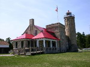
I paused at the south terminal of the bridge prior to crossing.
There is a small city park there with informational signs about the
bridge, beaches, a visitors center, and an old light house. The
lighthouse. The lighthouse is the Old Mackinac Point Lighthouse
built in 1892. Its light guided ships on the Straits of Mackinac for
66 years. Until its closure December 1957 after the Mackinac Bridge
opened. Old Mackinac Point is listed in the National and State
Registers of Historic Places.
The bridge crosses from the town of Mackinac in the lower peninsula
to the city of St. Ignace on the north end. The bridge crosses the
narrow straight between Lake Michigan to the west and Lake Huron to
the east. A visitors center to the upper peninsula lies just off the
bridges north end. My original plan was to travel to Tahquamennon
Falls State Park in the eastern portion of the Upper peninsula, but
at this stage I was running late and decided to head directly to
Pictured Rocks. I am sorry I missed visiting the state park looking
back on things, but at the time.

I approached the lakeshore for the south and east coming in from the
Grand Marais side of the park. Grand Marais is a picturesque
community. There are volleyball courts set up on the beach with
sailing vessels anchored in the bay beyond. I continued on to the
Grand Sable Visitor Center, and then to the Hurricane River
Campground to grab a campsite before I began any explorations. I
started with stopping for some dinner at an old-time style diner in
Grand Marais. Inside I found magazines from the American Chestnut
Foundation, and a book on Great Trees of the World. I talked to the
owner of the place after eating. It seems he joined the ACF and had
planted some specimens in his yard and around the diner, as well as
specimens of a number of other specimen trees that so far seemed to
be surviving the Michigan winters.
From here it was off to the Sable Area of the Lakeshore. (Map: http://www.nps.gov/piro/planyourvisit/upload/PIROmap.pdf
) the roads
in this part of the park are sand. They travel in and out from
properties belonging to the National Park Service, Lake Superior
State Forest, Hiawatha national Forest, and various private
landowners. "Pictured Rocks National Lakeshore is located along
the south shore of Lake Superior, between the communities of
Munising and Grand Marais, in the north woods of Michigan's Upper
Peninsula. It was authorized by Congress as the first national
lakeshore on October 15, 1966, "to preserve for the benefit,
inspiration, education, recreational use, and enjoyment of the
public a significant portion of the diminishing shoreline of the
United States and its related geographic and scientific
features" (P.L. 89-668). The "diminishing shoreline"
refers to public access to Great Lakes shores lost to private
ownership. Formal establishment of the national lakeshore came on
October 6, 1972. The 71,397 acres of the park are divided
approximately equally by the enabling legislation into two distinct
ownership and management zones. The federally-owned Shoreline Zone
was established for the traditional national park reasons of
preserving natural and cultural resources and providing for
recreation. The non-federal Inland Buffer Zone (IBZ) was created
"to stabilize and protect the existing character and uses of
the land, waters, and other properties within such zone."
Congress intended that the buffer zone serve to preserve the setting
of the Lake Superior shoreline and inland lakes, and protect the
watersheds and streams. Sustained yield timber harvesting and other
resource management activities compatible with preservation and
recreational use were permitted in the IBZ. Consumptive resource
use, however, was intended to be subordinate to public recreation
and the protection of "the usefulness and attractiveness of the
lakeshore." The IBZ is comprised of national and state forest
land, extensive private commercial forest, and small private
parcels. The park boundary extends one-quarter mile out over the
surface of Lake Superior along the length of the park. National Park
Service authority is limited to the surface waters within this
one-quarter mile. "
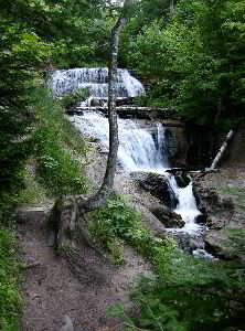
Sable Falls
The first stop was to see Sable Falls located just off the Sable
Falls picnic area located about one mile west of Grand Marais on
Alger County Road H-58. Sable Falls tumbles 75 feet over several
cliffs of Munising and Jacobsville sandstone formations on its way
to Lake Superior. The first viewing platform is down a staircase
with 169 steps. The hike from the parking area to this staircase
steps is short. Unfortunately when I visited there steps were being
repaired. I was able to hike to the bottom of the falls but the
trail to Lake Superior was closed. Another short trail leads from
the parking lot to the Sable Dunes area. I have briefly mentioned
portions of this trip in a previous post about epiphytes found at
the site: http://www.nativetreesociety.org/fieldtrips/michigan/pictured_rocks.htm
This is another access point for the dunes is from the North Country
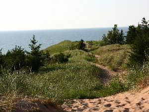
Trail, one-quarter mile east of the Log Slide. Five square miles of
Grand Sable Dunes are perched atop the 300-foot high Grand Sable
Banks. Left by enormous glaciers, the Grand Sable Dunes dwarf
comprehension. A portion of the Grand Sable Dunes is set aside as a
Research Natural Area. Grand Sable Dunes RNA site bulletin
(pdf) One
point I wanted to mention were the Jack Pines in the Sable Dunes
area. The Grand Sable Dunes Trail runs a half mile from the parking
lot, through a Jack Pine forest, to grassy dunes, to the Lake
Superior shore. One sign reads, "At this point the jack pine
forest meets the Grand Sable Dunes. The dunes are a dynamic and
unsettled environment compared to the serene forest. As you ascend
you will notice marked changes in light intensity, wind velocity,
temperature, and soil composition. Here in this narrow transitional
zone, pine saplings are encroaching on the dunes, while sand
sometimes spills into the woods."
 |
 |
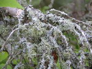
At this point are numerous Jack Pine trees 15 to 30 feet high. What
was of particular interest were the large numbers of epiphytic
lichens on the Jack Pine branches (see attached photo) The branches
on the lower part of the trees were often completely covered. The
amounts may have caused the death of some of these branches in these
trees. The upper branches tended to be much greener than the lower
branches, although green needles were present on many of the
branches covered with the Epiphytes. I am proposing that these
Epiphytes are growing so well because of aerosol spray blown from
Lake Superior, and fog from lake Superior collecting in the branches
of these first trees on the edge of the dune fields. I still find it
curious that they have preferentially infested the Jack Pines,
suggesting that the Jack Pines are in some way a better host than
other species in the forest. Beyond the Jack Pines the trail opens
into the open dunes themselves. Here was the remnants of a buried
"ghost forest" that had been overtopped by sand dunes. On
the way back passing through the Jack Pines and other tree species
beyond, I discovered that large areas of the forest floor were
covered by Lady Slipper plants. These are a native orchid that
blooms in early spring. I am not sure if these would be yellow or
pin lady Slippers, but am sure they are spectacular in the spring.
(Maybe Paul Jost would know?) After this I had a chance to stop by a
boat launch on the far side of Grand Sable Lake to get a few shots
of the dune fields between the lake and Lake Superior. A herd white
tailed deer were bouncing through grasslands as I traveled around
the lake.
As this is a tree interest group, there is some information about
the forests in the park on their website: "Pictured Rocks lies
within the northern hardwood/hemlock/white pine region of the
eastern deciduous forest. This forest type is transitional between
the more homogeneously deciduous forests to the south and the
coniferous boreal forests to the north. About 80 percent of the
lakeshore is dominated by upland northern hardwoods. Dominant
species are beech (Fagus americanus), sugar maple (Acer saccharum),
red maple (Acer rubrum), yellow birch (Betula allegheniensis),
hemlock (Tsuga canadensis), and white pine (Pinus strobus). On
coarse outwash and coastal sands (about 10 percent of the
Lakeshore), red pine (Pinus resinosa), white pine and jack pine (Pinus
banksiana) are dominant. Successional stands within these soils
contain considerable amounts of paper birch (Betula papyrifera) and
aspen (Populus tremuloides). Ground and crown fires influenced this
pine-dominated vegetation prior to European settlement. Scattered
small patches of wetter habitat occur on upland benches and in
poorly drained topographic lows (about 10 percent of the Lakeshore).
These contain boreal forest elements such as black spruce (Picea
mariana), white spruce (Picea glauca), white cedar (Thuja
occidentalis), and larch (Larix laricina). Larger white cedar glades
within the national lakeshore are southwest of Grand Sable Lake,
south of Au Sable Point, along the southern and western edges of
Beaver Basin, and east and south of Miners Basin."
 |
 |
There is little, and likely no remaining primary forest in the
National Lakeshore. The area was heavily logged and artifacts from
the mining days are featured at several locations. Just west of the
Sable Dunes is an area known as the "Log Slide." An
interpretive sign reads in part: "Lumberjacks cut the pine and
swamp white cedars to construct growing Midwestern cities. Logs were
cut primarily in the winter, processed at local sawmills in Grand
Marias and Munsing, then shipped by steamer to Cleveland, Chicago,
ad Milwaukee. In one year alone, the sawmills of Grand Marias
shipped over fourteen million board feet of lumber." The
forests have still not recovered well. Large areas of the park are
populated by white birch trees. These often are the first species to
repopulate a disturbed area, and if the soil is poor, they may
persist for long periods of time. Many of the pine and cedar forests
have been replaced by these white birch tracks. Some of this history
can be seen at the Log Slide area. The website reports:
"Located about 7 miles west of Grand Marais on Alger County
Road H-58, then almost 1 mile north on Log Slide Road. Legend has it
that logs sent down the dry log chute would generate enough friction
to cause the chute to catch fire. Today the chute is gone, but the
lumberjack stories still linger as you gaze out over the Grand Sable
Banks and Dunes. This is a good place to glimpse the Au Sable Light
Station to the west and the Grand Sable Banks and Grand Marais to
the east." A trail extends from a parking area to an overlook
platform high above Lake Superior.
 |
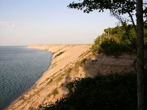 |
Immediately off the parking area to the Log Slide is the crumbling,
barely distinguishable remains of a settlers log cabin. From here
the trail passes through a white birch forest. After a short
distance there is a wooded shed that houses some of the artifacts
from the lumbering days. Prominent are some gigantic wheels used to
haul logs via horses in the rough terrain. The trail leads to a
platform at the top of the Grand Sable Banks and Dunes. Here they
stand about 300 feet above the level of Lake Superior. The Au sable
Light Station can be seen in the distance to the west from the
platform.
The size of Lake Superior dominate the entire northern view from the
platform. "Lake Superior is the major water body in the area
and forms the northern border of Pictured Rocks National Lakeshore.
The lake has a maximum depth of 420 m (1,335 feet) but is relatively
shallow near PRNL's shoreline. Its surface lies at an elevation of
187 m (600 feet) above sea level. The maximum tidal/storm elevation
has been recorded at 604.3 feet. In recent times lake level has
varied on the order of several feet due to changes in precipitation
and evaporation." Lake Superior has the largest surface area of
any fresh water lake in the world. As such it dominates the weather
of the Pictured Rocks National Lakeshore. "The lakeshore is
located approximately 46 degrees north latitude and 86 degrees west
longitude. The coldest months average well below 0°C (32°F) and
the warmer months about 22°C (70°F). Lake Superior greatly
ameliorates temperature extremes, slowing spring warming and the
onset of winter. The average date of the last freezing temperature
in spring is June 8, and the average first fall freeze is September
23; however, freezing can occur during any month. The freeze-free
period, or growing season, averages 107 days annually. The big
lake's presence also increases precipitation in the lakeshore.
Annual precipitation averages 79 cm (31 inches); annual snowfall is
320 cm (126 inches). Snow generally covers the ground from late
November through late April. The area is within the second-most
cloudy region of the United States, characterized by an annual mean
cloud cover of 70 percent. Much of the cloudiness occurs in autumn
and winter and can be attributed to cool air flowing over Lake
Superior being warmed along the shore and forming clouds. This
condition also often results in rain, fog, and snow. Spring is
relatively clear due to the cold water surface of the lake."
It
was getting lake and I arrived back at the campground shortly after
dark.

August 8, 2008. The morning came quickly and I was ready to tackle
the major hike of the trip to Pictured Rocks. The goal was to hike
the loop around Grand Portal Point, and area of the park that
contains the most spectacular cliffs, and arches. The trailhead
begins at the end of a long dirt road in the Chapel Falls parking
lot. I choose to travel the loop counter-clockwise to take best
advantage of the morning light. The trail leads first across a
relatively flat plateau to the east of Chapel Lake. The first site
to see about 1.5 miles down the trail is Chapel Falls. The NPS
website reads: "After a brisk 1.5 mile walk past abundant
stands of jewel weed, hikers can view the 60 foot high Chapel Falls
as it cascades toward Chapel Lake. The trail is on an old roadbed
with several small hills. Two viewing platforms along the way
provide views of the scenic Chapel Basin. The trail continues to
Chapel Rock and Lake Superior."

Chapel Falls
The first place to see the falls is at essentially the top of the
waterfall. From there the trail continues toward Lake Superior.
About a half mile farther along is another viewing area which gives
you a straight on view of the falls. Beyond the trail continues
across the plateau top toward the lake. Perhaps it was the
anticipation, but this last mile or so of the trail seemed to take
forever to complete. Finally he trail descends in a series of
switchbacks to lake level. At the bottom of the trail is one of the
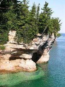
iconic features of the Lakeshore- Chapel Rock.

Chapel Rock |
 |
Chapel Rock is a open arch separated from the main cliff by a gap of
ten feet or so. Atop the rock is a large Pine tree growing on the
almost bare rock, A single fat root bridges the gap between Chapel
Rock itself and the main cliff face. Spectacular. The NPS website
reads: "The Chapel area was named by early European explorers
and is found on early maps as La Chappelle. Chapel Rock is a remnant
of Cambrian age sandstone. The archway between the rock and the
mainland collapsed in the 1940's. It and the remaining arch were
carved by Lake Nipissing high waters some 3800 years ago. Chapel
Beach is also a remnant of Lake Nipissing, blocking Chapel Creek to
form Chapel Lake. The area invites hikers and boaters to linger, and
a popular backcountry campsite is found here." Just off the
rock is a popular beach known as Chapel Beach. Also of note is the
outflow stream leading from Chapel Falls. The most impressive
feature of the area are the massive pink sandstone cliffs that begin
to the west of the beach area.
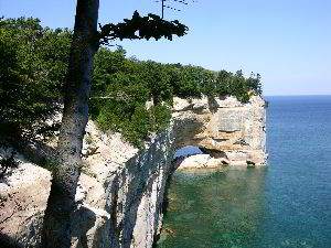
The NPS website reads: "The Pictured Rocks stretch for about 15
miles along Lake Superior from Sand Point on the west to just after
Spray Falls on the east. Colorful and bold, the Pictured Rocks tower
50 to 200 feet directly from Lake Superior. The name "Pictured
Rocks" comes from the streaks of mineral stain that decorate
the face of the weather-sculpted cliffs. Sandstone cliffs of ochre,
tan, and brown - sandwiched with layers of white, green, orange, and
black - glisten against the cloud-streaked sky and clear waters of
Lake Superior." After a short stroll up the beach the trail
again leads to the cliff tops. The trail follows atop the cliff
presenting at every aspect views of pink water carved sandstone
cliffs plunging into green, turquoise, and azure blue water. Pines
form an icing atop the cliffs in contrasting color. The trail leads
around what is called Grand Portal Point for a distance of about 4.5
miles until mosquito beach is reached on the far side. There were
few other hikers that day and the trip was made in peace with
frequent photo stops. I did encounter a group of about a dozen high
school girls headed the other direction to Chapel Beach, but for the
most part was alone. The far side of the point is marked by a rocky
shore at the end of the Mosquito Trail. Located just inshore is a
primitive pack in campground. I followed the Mosquito Trail back to
the parking lot, and left on to my next stop.
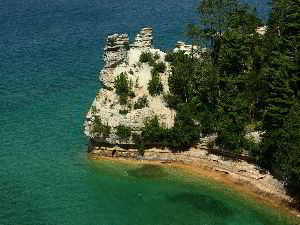
Miners Castle
The next area I visited was an area know as Miners Castle. Miners
Castle. "Miners Castle is the most famous formation of the
Pictured Rocks, and is accessible by vehicle and short trails.
Beginning at the picnic area, a paved foot trail leads past
interpretive exhibits to breathtaking overlooks of Lake Superior and
Grand Island. Stairs and a steeper trail lead to the lower overlook
adjacent to Miners Castle. " Reading on the park website there
was some type of a large collapse at Miners Castle in 2006. My
photos are before the event, and have not been back since to see
what changed.
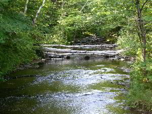
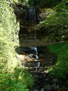 Munsing Falls
The final stop was in the town of Munsing. I stopped at the Munsing
Visitors Center and took the short hike to Munsing Falls. The NPS
website reads: "Located within the city limits of Munising
where Washington Street becomes Sand Point Road, near Munising
Memorial Hospital. The Munising Falls Interpretive Center is at the
beginning of the trail to the waterfalls. Walk the paved .25 mile
trail up the cool shaded sandstone canyon along Munising Creek to
the base of the falls. Two sets of stairs lead to platforms to view
the 50 foot waterfall as it drops over a sandstone cliff. Watch for
ferns, wildflowers, and an occasional mink. The trail is fully
accessible to the central falls viewing platform. Please stay on the
paved trail. Pets are permitted on the trail to Munising
Falls." The fall was very thin this time of the year, but still
worth the short walk to see it. This was my final stop at Pictured
Rocks National Lakeshore. From here I headed west toward Wisconsin.
== 2 of 2 ==
Date: Wed, Mar 26 2008 9:46 pm
From: James Parton
Ed,
Through your words and pictures you have taken us on another great
trip!
Goodnight: James.
==============================================================================
TOPIC: Pictured Rocks National Lakeshore, MI
http://groups.google.com/group/entstrees/browse_thread/thread/1ec673af41903fc5?hl=en
==============================================================================
== 1 of 4 ==
Date: Thurs, Mar 27 2008 11:40 am
From: Daniel P Mcconnell
Thanks for the post, I enjoyed it. PRNL is very close to home,
literally. I live a few miles away from the western border. Much of
the
park is very rich mature hardwoods, with pockets of old growth (some
virgin, I suspect) hosting giant beech and dandy sugar maple. The
largest beech I have ever seen are near little beaver lake
campground,
along with one of the girthiest white pines up a trib. of little
beaver
creek. My stepdad found it back in the 1980's or so and told me
where
to find it. Not only did I find it, but there is now also the
"white
pine interpretive trail" that takes you to it. Most of the
beech are
under attack by the bark disease. A crying shame.... our beech
forests
are degrading rapidly. I cannot imagine PRNL without beech, it's
such a
dominant player. -
Danny
==============================================================================
TOPIC: Pictured Rocks National Lakeshore, MI
http://groups.google.com/group/entstrees/browse_thread/thread/1ec673af41903fc5?hl=en
==============================================================================
== 1 of 4 ==
Date: Fri, Mar 28 2008 9:21 am
From: doug bidlack
Ed,
your post really reminds me of all the wonderful times
I had when my family would visit this park. We would
visit almost every year in late summer and we always
liked to camp around little beaver lake so we could
fish this lake as well as big beaver lake. We also
always walked over to Lake Superior over a sandy trail
to a nice long beach with few, if any, people. I went
back with my wife on our honeymoon in July of 2001.
We wanted to kayak the coast but it was too rough, so
we just hiked to a bunch of waterfalls, dunes and
lookouts. Great fun!
BTW, I love the way you incorporate your photos into
your posts. What software do you use? I'd love to
be able to do the same thing. Will also does the same
thing and his posts are also really great.
Doug
|