| Porcupine
Mountains snow forest |
Lee
E. Frelich |
| Apr
26, 2004 09:49 PDT |
Bob:
This past weekend I went to the Porcupine Mountains, MI, with 4
students
from my disturbance ecology class. We saw the entire gradient
from dwarf
oak forests 12 feet tall, to moderately statured sugar maple 80
feet tall
to 110 foot sugar maple, basswood and ash at low elevations.
From Lake of the Clouds overlook (first range from Lake
Superior) we could
see the snow line on the second range, which reaches higher
elevations, and
decided to hike across the Big Carp River Valley and up the
second range to
the snow line. Hemlock also drops out exactly where the snow
line is. The
upper range limit for hemlock appears to be caused by snow load,
and above
a certain elevation the trees break off frequently. As one
approaches the
upper hemlock limit, there is a zone perhaps 1/4 mile wide where
hemlocks
never attain a height greater than 20 feet, and all of their
crowns have
been broken many times, so they are like large shrubs. Then they
disappear,
and deciduous snow forest takes over with sugar maple, yellow
birch,
basswood and red oak trees about 80 feet tall. 250 inches of
snow were
recorded at lower elevations this winter, and who knows how much
(my guess
is 400+ inches) fell in the high elevation snow forests. There
is still
1-2 feet of snow where we were, and 2+ feet at Summit peak,
which we were
unable to access. A few of the maples were starting to flower
with snow
still at their base, since so much snow fell that enough growing
degree
days could accumulate at the level of the canopy to cause
flowering without
melting all of the snow. The snow also insulates the ground, so
that it
never freezes, which also allows the trees to begin growing with
snow still
on the ground.
This is a really interesting forest, which changes from conifer
to
hardwoods with higher elevation--the opposite direction that
occurs on most
other elevational gradients.
Lee |
| Re:
Porcupine Mountains snow forest |
Paul
Jost |
| Apr
26, 2004 11:19 PDT |
Lee,
Did you cross over the second ridge to get to the other side?
Did the
snow continue all the way down the back side of the second
ridge? I
have seen this pattern before. It seems that the heavy snow
starts at
the second ridge and then continues southeast of it to the ridge
on
South Boundary Road. Beyond the second ridge, altitude partially
falls
out of the equation regarding depth of snow cover...
These are links to previous Landsat images that show the snow
pattern in
the Porkies that I am talking about. You can see that by the
first
week in May, snow is usually gone from the surrounding parts of
Wisconsin and Michigan, but remains in the heart of the Porkies
practically until Memorial Day:
Porkies Snow Cover Aerial Photo:
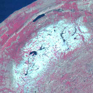
Paul Jost
|
| Re:
Porcupine Mountains snow forest |
Lee
E. Frelich |
| Apr
26, 2004 11:46 PDT |
Paul:
No, we didn't hike to the other side of the second ridge, where
distance
from lake becomes as important as elevation in enhancing
snowfall. That
would have been difficult because it was above freezing and we
kept
breaking through the snow. However, we could see from driving
part way
down South Boundary Road on either end that the snow pattern was
similar to
what is shown in your Landsat image. The snow is more extensive
at this
time than in the image, so that the middle third of South
Boundary Road,
which is clear of snow in the image, is snow covered and
unpassable, which
isn't surprising for late April. Bob Sprague told me they might
try to get
the road open by the end of this week.
It is interesting to note that at this time there is also an
area of snow
in the Huron Mountains just west of Marquette MI, and in the
eastern
Boundary Waters in northern MN. Those three areas have a ridge
that causes
orographic enhancement and lake enhancement of snowfall combined
with
relatively high elevation, dense forest cover, and cold springs
due to
proximity of the lake and northern latitude, resulting in
persistence of
snow into May. So, I guess we have three snow forests in the
Midwest.
Lee
|
| Re:
Porcupine Mountains snow forest |
Miles
Lowry |
| Apr
28, 2004 10:27 PDT |
| Lee,
During my
mountaineering days, we would call falling through the snow
"post-holing"...not a pleasant experience with heavy
pack and climbing gear1
Miles Lowry
|
| RE:
Snowfalls capture the record hunter's imagination |
Lee
E. Frelich |
| Jun
17, 2004 06:14 PDT |
Neil:
... the Lake Superior snowbelt of
Upper Michigan must have the heaviest snowfall among the
snowbelts. Lake
Superior rarely freezes because of its size and depth, it has a
bigger
surface area over which the wind blows, and the arctic air
blowing over it
is colder than arctic air that makes it out to NY. That must be
the
explanation for 250 inch average snowfalls reported in places
like Houghton
and Ontonagon, MI. According to the satellite analyses the
National
Hydrological Center does, those towns are not even in the areas
with the
heaviest snowfall, which occur in the highland maple forests of
the
Porcupine Mountains and Huron Mountains. The snow in these two
areas
causes hemlock to drop out of the forest. As you hike inland
from Lake
Superior, the maximum height hemlock can attain falls from 115
feet to
about 40 feet, at which point all of the hemlocks have multiple
broken
crown tops, and then hemlock disappears, while sugar maple, red
maple,
yellow birch, black ash, and red oak, continue to attain full
size of 80-90
feet. Thus we have a deciduous-dominated 'snow forest' like the
one in
northern Japan. A few white spruce and white pine are mixed in
with the
deciduous trees and also attain normal sizes. Curious that they
can still
grow tall with all the snow and hemlock can't. Hemlock must not
be able to
shed snow.
Lee
|
| RE:
Snowfalls capture the record hunter's imagination |
Dee
& Neil Pederson |
| Jun
18, 2004 13:46 PDT |
Hi Lee,
Your comments triggered curiosity in me about
Great Lake snow fall. I surfed for more
Great Lake info and dove back into a Great Lake
snow fall reference I have. This is what I found:
Yes, the western Great Lakes are a significant
snow producers because of their size and depth.
The upper Michigan lake effect region appears to
experience the largest "climatological impact"
in the United States:
http://www.islandnet.com/%7Esee/weather/elements/lkefsnw3.htm
Its pretty cool to think that this special
region and its climate significantly impact the
forest, especially the hemlock. Seems like the
area of snow and forest ecology is a ripe field
for the picking.
Though much smaller than the western Great
Lakes, Lake Ontario can be a significant snow
producer because of its E-W orientation and being
at the tail end of the Great Lakes climate
system. The E-W orientations allows storms moving
in the prevailing westerly wind direction pick up
additional moisture moving across Ontario. Also,
several central NY storms earlier this year were
enhanced by additional moisture from the western
Great Lakes. They call it "upstream lake
connection":
http://www.erh.noaa.gov/buf/lakeffect/03-04.html
This is probably not the first year it happened
and may explain why central NY and the Tug Hill
region is said to be a region among those with
"the most spectacular lake-effect snow squalls."
There is a neat paper on the spatiotemporal
trends in lake effect snowfall in the Great Lakes
from 1951-1980 [Norton and Bolsenga, 1993;
Journal of Climate]. The long-term average from
1951-1980 put the area south and east of Lake
Superior and the Tug Hill in the same class, >
400 cm per year. At the end of the paper they
zoom in on both regions and create contour maps
for certain periods. The area in the UP between
Baraga and Big Bay
[http://www.exploringthenorth.com/mich/upmap.html]
is the high point. The average snowfall in this
area between 1976 and 1980 averaged 660+ cm. The
high point in the Tug Hill averaged more than 900
cm for the same time period. Certainly the
density and quality of observer network/stations
influence this study. It will be nice in 20 years
when a high quality, satellite based study is
done.
Somewhat related: I looked at daily snow depth
maps this winter. Granted it was uncorrected
radar data, but it seemed have at least relative
snow depths correct. I was amazed at quick
development [~ < 5 days] of the snow pack at the
end of January and beginning of February in
northeast MN and northern WI. Snow depth was
nearly a meter according to the data and seemed
to appear overnight. It was centered squarely
around the western tip of Lake Superior. Do you
recall this event Lee? Looked like a doozy.
Neil
|
| Porcupine
Mountain Snowfall |
Robert
Leverett |
| Jan
25, 2005 11:57 PST |
Lee:
It sounds like the snowiest regions of the Porkies get upwards
of 300
inches of snow per year. I think you've indicated numbers in
that range
before. What percentage of the cold season will the big hemlocks
that we
saw several years ago have their bases buried in snow? Of
course, the
direction this question points is to the snow insulation factor
and its
effect of the hemlock's condition in terms of protection and
readiness
to take off and grow when the snow melts.
Bob
|
| RE:
SOOOPA! |
Lee
E. Frelich |
| Jan
25, 2005 12:12 PST |
Bob:
Snow usually arrives there during late October and continues at
low
elevation until mid to late April, and in upper elevations until
Mid to
late May.
The soil never freezes due to insulation from the snow, which
helps
conifers, which are susceptible to root freezing. On the other
hand, the
snow accumulation on the crowns of trees also limits hemlock in
higher
areas of the park by breaking the crowns. Hemlocks are not
efficient at
shedding snow.
Lee
|
| RE:
SOOOPA! Winter Temps and Snow Cover |
Neil
Pederson |
| Jan
25, 2005 15:27 PST |
Bob, Lee, ENTS:
I like the snow cover idea and its relationship as a factor of
tree
growth. the first paper of my dissertation was published in
which I
drew up a hypothesis on just this subject.
I found that the radial growth of the
oak-hickory forest [driven
mostly by white oak and chestnut oak] are more sensitive to
January
temperatures in the southern half of the Hudson Valley than in
the
foothills of the Adirondack and Taconic Mountains. This
completely
contradicted what I was expecting. As Lee suggests, I
hypothesize
that the ephemeral snow cover in the lower half of the Hudson
Valley
subjects the soil to increased freezing compared to the
Adirondack
and Taconic Mountains. Soil temperatures just below freezing
have
been shown to significantly increase fine root mortality in the
White
Mountains of NH.
Of course, my Hudson Valley hypothesis needs testing.
If anyone is interested in this paper, I can send along a PDF of
it.
Pederson, N., E.R. Cook, G.C. Jacoby, D.M. Peteet, and K.L. Griffin.
2004. The influence of winter temperatures on the annual radial
growth of six northern-range-margin tree species. Dendrochronologia
22: 7-29.
Neil
|
|