| South
Manitou Island - Thuja Search |
Ernie
Ostuno |
| Sep
11, 2007 17:58 PDT |
ENTS,
Lee Frelich and I went to South Manitou Island over the weekend
to look
for a new world champion Northern White Cedar.
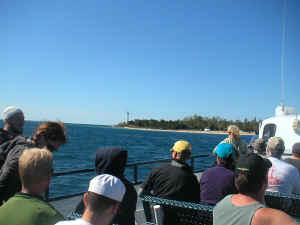
The ferry boat arriving at the island, with a view
of the lighthouse.
The old champ at
this
site had died several years ago. A full trip report will be
forthcoming,
but here are the numbers for the biggest trees we found in order
of
height:
Northern White Cedar 104" 83.4'
Northern White Cedar N/A 79.6'
Northern White Cedar 136" 78.0' Spread: 46'
Northern White Cedar 145" 77.7' Spread: 24'
Northern White Cedar 108" 74.8'
Northern White Cedar 149" 67.5'
Northern White Cedar 179" N/A....Old Champ, dead
Northern White Cedar 186" N/A....Fallen over, dead
Ironwood 40" 59.5'
We could not break 85 feet in height, although we limited
ourselves to
measuring the trees with the greatest girth, and there may have
been a
skinnier cedar that could have exceeded 85 feet. The published
height of
113' for the old champion was way off, as we suspected. It was
probably
in the 80 to 85 foot range before it died. A giant fallen cedar
had a
very impressive cbh of 15.5 feet. Many of the trees, including
the
ironwood, were leaning quite a bit. We measured the spread for
the two
largest trees and, despite its smaller crown spread, it looks
like the
77.7 footer will be the points champion based on its greater
girth of
145".
Ernie
|
| RE:
South Manitou Island - Thuja Search |
Will
Blozan |
| Sep
12, 2007 05:34 PDT |
Ernie,
Great stuff- I look forward to the full report. What do you see
as the
source of height error on the former champ? Did you see it
before it fell?
Will
|
| Re:
South Manitou Island - Thuja Search |
Lee
E. Frelich |
| Sep
12, 2007 08:17 PDT |
Miles:
The ancient cedars have a hiking trail to them from the ferry
dock, and are
marked on all the maps. There are many interesting cedars near
the trail.
Its about a 7 mile round trip hike from ferry dock to ancient
cedars and
back. If you do it as a day trip, you will only have an hour to
spend in
the cedars. Camping is semi-primitive by backpack. The Weather
Station
Campground is closest to the cedars.
You have to have reservations on the Manitou Island Ferry which
runs from
Leland MI, and at this time of year only runs a few times a week
and ends
October 6th for the season: http://www.leelanau.com/manitou/manitou.html
Lee
At 07:37 AM 9/12/2007, you wrote:
| |
Ernie
and Lee,
I'll be going to the island soon as a continuation of my
photo project.
Any hints you can share about finding the area you
surveyed?
Thanks in advance... Miles Lowry
|
|
| South
Manitou Island Trip Report |
Ernie
Ostuno |
|
Sep
12, 2007 13:59 PDT |
Here is the full trip report. I sent some photos to Ed for the
website.
Thanks to Lee for additions/corrections to the report and for
making the
trip out here. It was fascinating to see the actual evidence of
the
impact that earthworms have on the forest floor, something I
never would
have noticed otherwise.
Ernie
On Saturday, September 8, 2007, Lee Frelich and Ernie Ostuno
visited a
stand of ancient trees on South Manitou Island, in northern Lake
Michigan in order to find a successor to the former world
champion
Northern White Cedar, which had died several years ago.
Background
information on the island can be found from a previous trip
report:
http://www.nativetreesociety.org/fieldtrips/michigan/manitou/south_manitou_island.htm
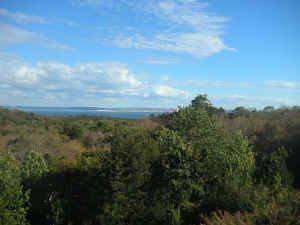
The ferry from Leland, Michigan departed at 10 am and the
weather was
clear and the lake calm, in stark contrast to the howling gales
and 6
foot waves from the previous evening. The dark blue sky met the
aquamarine hues of Lake Michigan in what seemed like unlimited
visibility. South Fox Island was visible on the northern horizon
about
25 miles away, and Point Betsie could be seen a similar distance
to the
south. We arrived at the island about 1130 am and docked at
Sandy Point,
on the south side of the natural harbor on the eastern side of
the
island. To the north is Gull Point, a large seagull rookery. We
disembarked, gathered our gear and registered with the Park
Service,
then high-tailed it on the inland trail to get our preferred
campsite at
the “Weather Station” campground, which is closest to the
old growth
area of the three campgrounds on the island. On the 1.2 mile
hike to the
campground we noticed several old hemlocks and some large maple
and
beech, and the air was filled with the sweet aroma of balsam
fir.
The understory was extremely lush because deer do not occur on
the
island, and many species of plants attain relatively huge size
because
they are not grazed by deer. Yew (Taxus Canadensis), a species
that has
been steadily disappearing due to deer grazing over the last
century, is
quite abundant in the forest understory on the island. Several
invasion
fronts of European earthworms were present, including the
nightcrawler.
Although the native plants were wiped out in some of these
invaded
areas, many areas still had lush vegetation because it is really
the
interaction of deer and earthworms that leads to a completely
denuded
forest understory.
We set up camp overlooking Lake Michigan, at the site closest to
the
access trail to the beach, which would be the most direct route
to the
big trees, about 2.5 miles away. On the hike along the beach we
saw
plenty of young cedars as well as a big white spruce. After
almost two
miles, the hulking, rusted remains of the Francisco Morazan came
into
view.
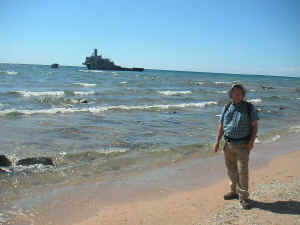
Lee Frelich in front of the wreck of the Francisco
Morazan, the most prominent of the many shipwrecks
around the island.
This is the most prominent of the many shipwrecks around
the
island, and serves as a landmark indicating where the trail to
the old
growth is. After taking some photos of the shipwreck, we
ascended the
steep dune and followed the trail into an area of big trees,
notably
sugar maple, yellow birch, beech and white ash in an area that
was
probably selectively logged for cedar. The maples across the
island were
largely defoliated, probably the result of saddled prominent, a
caterpillar that defoliates hardwoods except for white ash
during
droughts, and many trees looked drought-stressed. Lee noticed
the
luxurious understory and yet more evidence of the lack of deer;
a huge
Spikenard, about 6 feet tall.
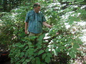
Lee examines the largest Spikenard he had ever seen. The lack of
deer on the island has allowed many understory plants to flourish and
attain sizes rarely seen elsewhere.
After another half mile, we reached “The Valley of the
Giants”, the area
along and between two large forested dunes where the ancient
cedars are
found. The first group of big cedars along the trail was
relatively
short, about 70 feet tall and not as thick as the trees further
on the
trail. We reconnoitered the trail, noting where the biggest
cedars were,
and then began measuring. We measured a big ironwood that Lee
had
noticed, and got a height close to 60 feet, pretty impressive
for this
species. As luck would have it, a hiker who was leading a group
of
students came down the trail, and turned out to be a tree
enthusiast who
had explored this stand before. He led us off the trail to what
he
believed was the leading contender for the title of new champion
cedar.
We measured it and then measured a few others, included girth
measurements of two dead giant cedars that may have been
champion trees
while alive. Their girths far exceeded any of the living cedars
we
measured. There are two close contenders for the championship
northern
white cedar; the first (champion by just a few points) is the
relatively
young 300-350 year old tree (shown to us by the hiker) with
straight
trunk and fairly symmetrical crown, while the other is several
hundred
years older, leaning with a twisted trunk and deep fissures in
the bark
filled with little moss gardens growing on sand deposited by
winds
blowing over the top of a nearby sand dune, and a highly
irregular
crown.
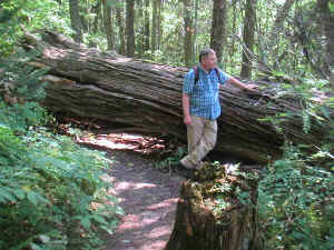
Lee contemplates a fallen giant cedar that he estimated may have been up to 900 years old. A cbh of 186 inches was measured and the height of the tree when standing was estimated at 75 to 80 feet. |
|
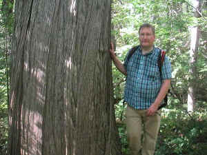
One of the two main contenders for the title of champion Thuja Occidentalis at this site with a measured height of 77.7 feet, cbh of 145 inches and spread of nearly 24 feet. |

Lee stands near the trunk of the 77.7 footer, which he estimates as being a relatively young tree compared to many of the other giants found here. This tree could continue growing for several more centuries.
|
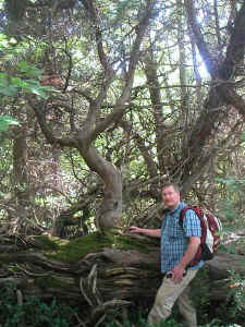
One of the most amazing finds here was that of this ancient fallen cedar that was actually still alive. At first sight we thought that this was a nurse log supporting a young cedar tree. But that young cedar turned out to be a limb of the fallen tree! In fact, two of the limbs of the fallen giant were still producing foliage and growing vertically up towards the sunlight from their gnarled bases. |

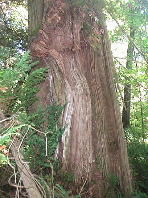
Although this cedar was a relatively short 67.5 feet in height, it had the greatest girth of the living cedars at 149 inches cbh. The girth was measured just under the large burl seen in the photo. Note the yew growing around the base of the tree. Yew was very widespread in the understory, reminding me of the rhododendron seen at many ancient hemlock stands. |
The white cedar forest is all aged, with many small seedlings,
saplings,
young pole-sized trees, and mature trees mixed together. The
ancient
trees are scattered about the 40 acre grove as single stems and
groups
of 2 or 3. Many of the ancient cedars have the same growth form
characteristics in old western red cedars portrayed by Bob
VanPelt. Lee
estimated ages of some up to 800 years.
After recording the measurements of the biggest trees, we
followed the
trail back out of the valley and then decided to make an assault
on the
huge perched dune across the western edge of the island. This
area
affords some of the most spectacular views in the entire Great
Lakes
region and, as we discovered, the trail passes by many species
of very
rare dune plants. Soon we were looking down on the forest we
just passed
through and at freighters crossing the Manitou Passage in front
of
Sleeping Bear Dunes. After admiring the panorama we trod on
along the
trail, looking for a way to the beach.
The view of the Manitou Passage and the Sleeping Bear dunes from the perched dune on the west side of the island. Many rare plants of the coastal dune ecosystem can be found here, as well as the spectacular panoramic view of the island and the surrounding land and water. |
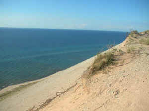
Looking northwest across Lake Michigan over the edge of the 350 foot perched dune along the southwest coast of the island. |
We followed fresh
footprints in
the sand which eventually led us to the edge of the tall perched
dune,
as well as a trail that ascended the very highest point on the
island.
We very briefly considered climbing the high point, but our
water was
pretty much gone and we thought better of it. Then we came to
the edge
of the dune. It was a rather steep 300 foot drop to Lake
Michigan and we
were somewhat intimidated by the thought of converting the
considerable
potential energy we had accrued to kinetic energy. Buoyed by the
sight
of footprints going down the steep drop, Ernie decided to take
the
plunge and began “sand surfing” down the dune followed by
Lee’s more
sensible and deliberate descent. We both had to carefully avoid
stomping
on several endangered Pitcher’s Thistle clinging to the steep
dune side.
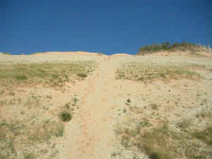
Lee is the tiny dot in the center top of the photo, gingerly making his way down the steep and fragile dune, careful not to trample some rare pitcher's thistles growing there. |
Young, verdant cedar trees basking in the late afternoon sunlight on the side of the perched dune on the southwest coast of the island. |
Upon reaching the beach, we began the 3.5 mile hike back to the
campground stopping only to get re-hydrated and fill our water
bottles
from the fresh water ocean of Lake Michigan. After a peaceful,
star-filled night’s sleep we broke camp and hiked along the
beach to
pick up the ferry back to the mainland. We looked for the
elusive
Petoskey Stone, a fossilized Devonian Period coral that is the
state
stone of Michigan, without success, although Lee found two nice
fossils
of another species of Devonian coral.
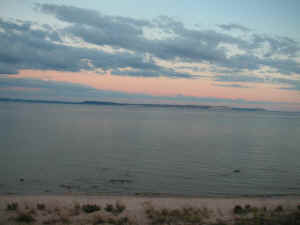
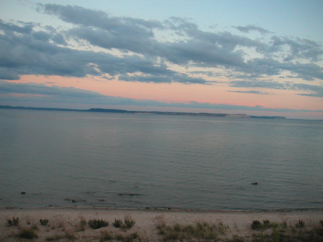
The view shortly after sunset from our campsite at the edge of
the dune, looking south across the Manitou Passage to Sleeping bear dunes.
The winds and waves really picked up as the ferry arrived and
the ride
back was considerably rougher, with the boat buffeted by 3 to 5
foot
waves. We pulled into the port of Leland around 230 pm and began
making
our respective ways back home.
|
| RE:
Thuja Search - original champion |
Ernie
Ostuno |
| Sep
12, 2007 15:00 PDT |
Will,
It was probably measured using the faulty method that resulted
in many
other trees being given heights that were about 25 percent
higher than
reality:
http://www.americanforests.org/resources/bigtrees/register.php?details=815
You'll notice that the date given as the most recent measurement
was
1953. I first saw the tree in 2002, at which point it was a
standing
snag with the top broken off. There was a wooden fence around
it, and a
sign describing it as the world champion white cedar. This is
what it
looked like in 2006:
http://www.nativetreesociety.org/fieldtrips/michigan/manitou/july2006029.jpg
Based on the height of the snag and the fallen crown, Lee and I
estimated a living height at no greater than 90 feet, and
perhaps less
than 85 feet.
Now look at the interpretive sign that marks the entrance to the
old
cedars:
http://www.nativetreesociety.org/fieldtrips/michigan/manitou/july2006044.jpg
They say the champion is "over 80 feet tall". So
someone must have
remeasured the tree and come up with a more realistic height
between
1953 and when that sign was made. Interestingly, the girth I
measured
for this tree was 179", quite a bit less than the 216"
mentioned in the
AF register, and less than the 206" mentioned on the
interpretive sign.
The tree has been dead at least 5 years, but the bark has not
fallen off
and I see no reason why the girth measurements would be so far
off.
There were two other large cedars, both of them dead, that may
have also
been large enough to be the champion, although they were not
marked by
the National Park Service with a sign or fence like the
179" cbh tree
was. This may have been intentional, according to a hiker we met
that
had researched the issue. However, neither of these trees had a
cbh
close to 200", and based on their remains were most likely
no taller
than the 179" cbh tree.
Ernie
|
| RE:
South Manitou Island - Thuja Search |
Lee
E. Frelich |
| Sep
12, 2007 18:46 PDT |
Will:
We were able to measure the snag of the former champ and the
broken top
lying nearby for an approximate height estimate of about 84-85
feet.
The former champ is right next to the tree that comes in 2nd
place in
Ernie's report, and there are also several other trees nearby,
all at the
base or on the side of a 100 foot high sand dune. You can tell
that the
dune has slowly moved over several centuries and that some of
the trees
have slid downhill--its all recorded in their weird looking
trunk
curvature. The former champ also shows evidence that the soils
level has
gone up at its base, probably due to sand sliding down from
above. Yet the
whole area is dense, deeply shaded forest with a yew understory
(which
prevents one from ever being able to see the base of the trees
from a
distance, but not quite as bad as Rhodo). Its the first time I
ever
experienced a forest where the trees apparently live long enough
to change
their geographic coordinates and elevation.
Its a very unusual place and one of the truly great natural
areas in
eastern North America, equal to the Boundary Waters, Porcupine
Mountains,
Cook Forest, Berkshires and Smokies in both scenery and natural
area quality.
Lee
|
| RE:
South Manitou Island Trip Report |
Will
Blozan |
| Sep
16, 2007 06:01 PDT |
Ernie and Lee,
Great report- thanks for sending it and I look forward to the
photos. FYI- I
have seen and crudely measured much larger specimens in the
foothills of the
Chic-choc Mountains, Gaspe Peninsula, Quebec. I think you are
looking for a
National Champion, not a world champion?
I hope to return to the grove again but don't see it happening
in the near
future...
Will
|
| RE:
South Manitou Island Trip Report |
Lee
Frelich |
| Sep
16, 2007 10:23 PDT |
Will:
Your'e probably right, its the national champion. In contrast to
most
species, northern white cedar seems to bigger in the north than
the south,
and tends to occur in areas hard to get to. Even the small but
ancient
cedars of the Niagara Escarpment require rock climbing to reach
them. I
have heard several reports about very large white cedars,
including some in
Quetico Provincial Park in Ontario, which would take several
days to get to
by canoe. South Manitou and the Chi Chocs are not exactly easy
to get to
either. There are some huge specimens in remote parts of the
Porcupine
Mountains as well. To find all the large white cedars and verify
the world
champion will take a deep northern wilderness type of person.
Lee
|
| RE:
South Manitou Island Trip Report |
Matthew
Hannum |
| Sep
16, 2007 13:50 PDT |
Hmmm... I find it rather interesting that this tree would grow
larger in
the northern end of its range. I wonder why that is? It seems
completely
illogical at first glance - lower latitudes mean longer growing
seasons
and less chance of frost damage, so the trees should be larger
in the
warmer climates, yet they are not. Anyone have any idea why this
would
be?
|
| RE:
South Manitou Island Trip Report |
Lee
E. Frelich |
| Sep
17, 2007 16:57 PDT |
Matthew:
In the case of northern white cedar they probably get larger in
the north
because decay is slower (i,e, they don't rot as fast and don't
fall over),
and the species is capable of taking advantage of a short
growing season.
Among the conifers in eastern North America, only black and
white spruce
and tamarack can take advantage of a shorter growing season than
white cedar.
Lee
|
| RE:
South Manitou Island Trip Report |
Ernie
Ostuno |
| Sep
17, 2007 23:34 PDT |
Will,
Let me know if you ever plan on going back up to the Gaspe to
find those
trees. I was up there in the summer of 1990, and it remains one
of the
most beautiful landscapes I have seen. I circumnavigated the
peninsula,
stopping for a night in Perce and then went around to the north
coast
before cutting back south through the Chic-chocs. The little
French-style villages, spectacular coastline, sheer cliffs, and
pastoral
farm country...made for quite the scenic road trip.
Are there any published measurements of cedars from north of the
border?
Or the Porkies? Right now I'm not sure if we found the world,
national,
or even island champion. According to Andy Sawyer, the tree
enthusiast
who showed us the location of the new big cedar, there is the
off chance
that South Manitou contains another grove of ancient cedars
tucked away
in the shadow of the perched dune, to the north of the
well-known stand.
An attempt to find it will probably have to wait until next
year.
|
| Re:
South Manitou Island Trip Report |
Jess
Riddle |
| Sep
19, 2007 09:45 PDT |
Ernie and Lee,
South Manitou Island sounds like a fantastic site. Thanks for
the
detailed description of your trip. I've been checking out a few
white
cedar stands lately, and can our imagine how impressive a grove
of
large, old ones would be.
Jess
|
|