|
ENTS,
Yesterday, Monica, Tanya Blaich (a new musical colleague of
Monica's), and yours truly went to the Hopper on Mount Greylock's
western slopes. My specific mission was to remeasure the champion
red spruce growing in a ravine below a scenic little waterfall. Both
the state champion red spruce (on points) and the height champion
grow on Mt. Greylock. The point champ is accessible to hikers from
the Roaring Brook Trail, but the height champ is off the trail
network in the recesses of the Hopper.
The weather cooperated and we made it to the spruce location without
rain - but once there, no spruce. Our champion is champion no
longer. I think the tree went down at least 3 years ago and
apparently broke up in its fall into the stream. There are
moss-covered chunks in the stream bed, but otherwise no evidence
that a flagship specimen of Picea rubens ever proudly stood as the
tallest accurately measured red spruce in all New England. This fine
tree was known to Lee Frelich and Will Blozan. Although I didn't
mention it to Monica, I had vaguely sensed not all was right with
the champion and was prepared to be philosophical about it. We Ents
live with the awareness that on any trip to visit a favored
champion, we may find our champion prostrate, the victim of disease,
insect infestation, or a capricious act of nature. So, the demise of
the red spruce champ, a somber discovery, did not completely
extinguish my desire to share the treasurers of the western slopes
of Greylock with my fellow and lady Ents. So, I concentrated on the
magic of the Hopper.
At 3,487 feet above mean sea level, Mount Greylock is
Massachusetts's highest summit and one of only three peaks in
Massachusetts to exceed 3,000 feet. The abrupt rise of Mount
Greylock stands in contrast to the plateau-like terrain of most of
the Berkshires uplands to the east. Greylock is a real mountain,
rising prominently above both its eastern and western bases. The
steep western slopes of Mount Greylock, where we were headed, rise
close to 2,400 feet above drainage of Hopper Brook as it flows out
of the Hopper and toward its union with the Green River.
The Hopper has been called an old glacial cirque, but not all
geologists agree with the interpretation, including darn good
amateur geologist Joe Zorzin. I am inclined to agree with the nay-sayers
based on the appearance of hundreds of cirque remnants that I have
looked seen and thought about.
Greylock is a popular destination for hikers, but the Hopper and
Money Brook trails aren't yet over-used. The trailhead lies at at
altitude of 1,100 feet in an attractive, open meadow and then
proceeds eastward. Along the way, the hiker can choose any of four
destinations, but our path was to be off trail. Our destination lies
between 2,000 and 2,100 feet altitude in an unnamed ravine, along an
unnamed stream, at the base of an unnamed waterfall. Is there a
pattern here? Gains and losses in elevation along the course gave us
an overall elevation gain of about 1,050 feet. Most of the way, the
route is easy to moderate in steepness, but the last part is much
steeper than to Monica's liking. The loose footing from all the rain
didn't help matters in either the easy or difficult parts.
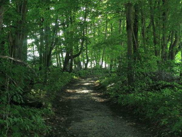
Image #1: The path into the Hopper from the trailhead starts by
following an old tree-lined road. Sugar maples and American
basswoods are plentiful. Yellow and black birch and black cherry
also announce their presence. Meadows/fields lie on both sides of
the path. Even though the forest corridor hold no trees of special
interest, the gestalt is aesthetic. Image #1 shows the path. The
direction of view is back toward the trailhead. Some of the larger
corridor trees exhibit half forest-grown, half-field grown forms.
The younger trees, growing up in the shade of their elders exhibit a
more classic forest-grown form.
Image #2: There are openings along the path that allow one to view
the surrounding peaks and be reminded that a lot of climbing lies
ahead. Image #2 is an example. It looks northeastward toward Mt.
Prospect, a 2,691-foot pleasingly contoured ridge with a trail to
the summit - a worthy goal in its own right. A word or two about
Prospect.
Image #3: From experience I can attest to a couple of excellent
views from Prospect. However, the forest on Prospect is
undistinguished second-growth, partly fire successional. Red and and
chestnut oaks are the rule near the summit. I've not found any
intact old growth on Prospect, but areas that are rapidly
approaching old-growth status exist.
Turning the camera around, I snapped Image #3 in an attempt to
capture an exquisite view of a foreground field set against the main
body of the Taconics. On the horizon, the New York-Massachusetts
border follows the crest of the Taconics, a mountain range that runs
along the border of Connecticut and New York, continues on the
border of Massachusetts and New York with 2,798-foot Berlin Mountain
being the high point of the Connecticut-Massachusetts-New York
section. The Taconics continue into Vermont where they reach their
greatest elevations west of Manchester. The hulking form of
3,864-foot Mount Equinox is the highest point of the range. The
Taconics peter out south of Rutland, Vermont.
The Greylock massif, which we were on, is geologically part of the
Taconics, although most people, visitors and locals alike, probably
think of Greylock as in the Berkshires. The term Berkshire is more
political than geological. U.S. Route 7 crosses the joining point of
Greylock to the main body of the Taconics between Williamstown and
Pittsfield.
Image #4: Most of the Hopper's terrain is steep, often very steep.
But there are a few places where one encounters a relatively flat
spot and for short stretches can catch the breath. In those idyllic
spots, one may linger and enjoy the deep woods feeling that the
Hopper offers. Image #4 is just such a spot. The hemlocks are
mature, but not old growth. There are plenty of stately trees on
Greylock, but few record breakers. When in places like that shown in
image #4, I have begun to turn off my measuring gene and just enjoy
the woodlands for what they have to offer.
Image #5: At the site of the once dominate red spruce, I turned my
attention to the surrounding woodland-mountain beauty. Image #5
looks westward through a peephole onto part of the Stony Ledge
ridge. In the late autumn, views in this region are spectacular. One
gets a big mountain feel when in the Hopper.
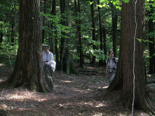
Image #6: Monica and I noticed that Tanya is able to appreciate
woodland aesthetics in the spirit of ENTS. So, invoking my ENTS
powers, I did the proper thing and named a tree for her. Tanya's
tree is a large white ash that I have measured about a dozen times.
It is one of the many trees that I track. The large ash now measures
10.5 feet in girth. The highest twig I could find, peering through
the dense canopy, reaches to 117.5 feet above the wide base. Based
on my many measurements of Fraxinus americana in Massachusetts ,
Tanya's tree is one of the patriarchs of its species and the
patriarch of that location. It has outlived the once champion
basswood a few yards distant. The basswood gave up the ghost about
10 years ago and now stands as a snag. Image #6 shows Tanya and her
tree.
By appearance, I judge Tanya's tree to be between 225 and 275 years
old. Don Bertolette and I once dated a large white ash of similar
dimensions and appearance on a side stream to Dunbar Brook in Monroe
State Forest. Don's age at coring height was 230 years. Tanya's tree
is very similar in appearance, maybe even older by half a century.
Image #7: The last photo is of yours truly standing by a large
northern red oak growing on the slope close to the unnamed stream.
The girth of this beautiful person (not me) is 11.7 feet as measured
at breast height. The tree's full height can't be measured this time
of year because of the dense canopy, but as I recall, it was about
107 feet a half dozen years ago. It's pretty flat-crowned, but may
now be over 110.
Well, that's it folks for the brief tour of Mount Greylock's Hopper.
Oh yes, I did measure striped maples to girths of 26-inches on a
catch as catch can basis. I wasn't specifically searching for them.
But Greylock nourishes substantially larger ones, the goal of a
future trip to re-connect with that delightful understory tree. My
record on Greylock and Massachusetts for striped maple is 40.7
inches in girth.
Bob
Continued
at:
http://groups.google.com/group/entstrees/browse_thread/thread/b3fef8e7d4fe5646?hl=en
|