|
==============================================================================
TOPIC: Donaldson's Woods Nature Preserve (Spring Mill State Park.
http://groups.google.com/group/entstrees/browse_thread/thread/4d50d2d099576b88?hl=en
==============================================================================
== 1 of 13 ==
Date: Sun, Jun 1 2008 8:22 pm
From: Randy Brown
On April 23 I visited Donaldson's Woods Nature Preserve, which is
par
of Spring Mill State park. It is located ~20 minute north by car
from
Pioneer Mother's Forest I described previously. I actually camped in
the state park and the old growth was an easy walk from the camp
ground. Don Bragg also described this site previously:
http://www.nativetreesociety.org/fieldtrips/indiana/spring_mill_state_park.htm
According to the interpretive sighs the site was purchased in the
1840's by an eccentric fellows by the name of Donaldson who like to
buy interesting looking properties. He insisted the site not be
disturbed, not even allowing hunting. It was then preserved by his
heirs until the site was acquired by the state.

The karst terrain of the forest sits on immediately strikes you as
very odd. Picture a flat plain peppered with huge pits. One gets the
impression of a place that's been carpet bombed with massive
ordinance. The pit's themselves are 20' to 40' deep, between a
fraction of an acre to maybe 2-3 acres in size. The smaller ones are
simple pits, but the larger ones have obvious seasonal streams that
drain into debris clogged sinkholes at the bottom. The ridges in
between the pits are obviously fairly dry as they are dominated by
white & red oaks and shagbark hickory (The diversity of the Oaks
and
hickories was noticeably less than the PMMF in the Hills to the
south) The midslopes have sugar maples and beaches and Ashes in the
midstory, with the moist bottom being dominated by tuliptrees. In a
few locations a single tuliptree has managed to win out over all
competitors in it's pit and grow monstrously larger and taller than
any other tree in the vicinity: 12'-15' cbh and 130-150' tall.
Generally the biggest and tallest trees where on midslopes crowed by
the 'core' grove of tuliptrees. Despite the abundance of white oak
and a lot of looking, the tallest white oak I found was 122.8' tall
(sorry Don). Though I did find a 134' Red Oak.
The state park in general has lots of garlic mustard, but I only
found
a few small patches in the Old Growth section, which I made a
sporting
attempt at eradicating.
|
Donaldson Woods Nature Preserve
|
CBH
|
Height
|
|
Tuliptree
|
15’ 01.5”
|
139.2
|
|
Sycamore
|
11’ 05.0”
|
116.6’
|
|
White Oak
|
?
|
115.0’
|
|
Red Oak (1508-1509)
|
10’ 10.0”
|
118.0’
|
|
White Oak
|
11’ 03.5”
|
114.7’
|
|
Shagbark Hickory
|
5’ 08.0”
|
128.8’
|
|
Beech
|
6’ 05.0”
|
116.0’
|
|
TulipTree
|
14’ 08.5”
|
150.8’
|
|
Mystery Hickory (1511-1514)
|
6’ 04.0”
|
128.6’
|
|
Shagbark Hickory
|
?
|
126.9’
|
|
Red Oak
|
8’ 02.5”
|
134.0’
|
|
White Oak
|
12’ 03.5”
|
122.8’
|
|
White Oak
|
8’ 07.0”
|
118.3’
|
|
White Oak
|
8’ 05.0”
|
121.4’
|
|
Black/Scarlet?
|
8’ 10.0”
|
118.0’
|
|
Tuliptree
|
15’ 01.0”
|
147.7’
|
|
Sugar Maple
|
5’ 04.0”
|
99.4’
|
|
Tuliptree
|
13’ 03.5”
|
149.7’
|
|
White/Green Ash
|
5’ 08.0”
|
108.0’
|
|
Bitternut Hickory (1522-1523)
|
4’ 10.0”
|
112.9’
|
|
Beech
|
8’ 07.5’
|
126.5’
|
|
Tuliptree
|
12’ 07.0”
|
142.4’
|
|
Donaldson Woods Nature Preserve Rucker10
|
CBH
|
Height
|
|
|
|
|
|
TulipTree
|
14’ 08.5”
|
150.8’
|
|
Red Oak
|
8’ 02.5”
|
134.0’
|
|
Shagbark Hickory
|
5’ 08.0”
|
128.8’
|
|
Mystery Hickory (1511-1514)
|
6’ 04.0”
|
128.6’
|
|
Beech
|
8’ 07.5’
|
126.5’
|
|
White Oak
|
12’ 03.5”
|
122.8’
|
|
Black/Scarlet?
|
8’ 10.0”
|
118.0’
|
|
Sycamore
|
11’ 05.0”
|
116.6’
|
|
Bitternut Hickory (1522-1523)
|
4’ 10.0”
|
112.9’
|
|
White/Green Ash
|
5’ 08.0”
|
108.0’
|
|
Rucker 10
|
8’ 07.9”
|
124.7’
|
== 6 of 13 ==
Date: Mon, Jun 2 2008 9:12 am
From: "Edward Frank"
ENTS,
Spring Mill State Park, Indiana is someplace I have never visited,
but I have studied the geology of the area. The Southern Indiana
area in general, and the Mitchell Plain area in particular, is one
of the classic karst areas of the United States. A karst landscape
is one in which the surface landforms have been formed by the
dissolution of bedrock. In this case the Salem Limestone and the St.
Louis Limestone, deposited 300 million during the Mississipian
Period, been dissolved to form a series of sinkholes. This area of
Indiana is located in what is called a driftless area - one in which
the surface is not covered by glacial till from the Pleistocene
glaciations. In a karst landscape virtually all of the surface water
flows into crevices ands sinkholes with no surface streams.

This water is then discharged at springs along the streams that cut
deep enough into the surface to reach the water table. One of the
major discharges from the emerges from the mouth of Donaldson Cave
and this spring discharge as used to power the earliest mills on the
site. There is an excellent pamphlet on the Geology of the park
available from the Indiana Department of parks: http://igs.indiana.edu/Geology/places/SPG7-Spring-Mill.pdf
The process of limestone dissolution is relatively simple but has
formed some of the most complex landscapes on the surface of the
earth, and fantastic features in cave passages below the surface.
Most of you while in school have put drops of acid on limestone and
seen it fizz from the release of carbon dioxide as the calcite
mineral dissolves. This isn't exactly how it works in nature. The
chemical equation is:
CaCO3 + H2O + CO2 <--> 2Ca++ + 2HCO3-
Basically the process of dissolving calcite in a natural carbonic
acid system sucks carbon dioxide from the atmosphere and creates
dissolved bicarbonate ions in solution. Precipitating calcite
release carbon dioxide into the atmosphere. (Blame all those nasty
coral reefs for releasing tons of carbon dioxide into the
atmosphere.) This dissolution process has formed the large number of
sinkholes (closed surface depressions formed by bedrock dissolution)
and caves found in the park. Areas of two of the caves, Donaldson
Cave and Twin Caves can be explored by visitors. Altogether there
are over nine named caves in the park.
http://www.terraserverusa.com/usgsentry.aspx?T=1&S=11&Z=16&X=1378&Y=10716&W=1&qs=%7cMitchell%7cIndiana%7c
A park website describes the nature preserves in the park: http://www.in.gov/dnr/3538.htm
Donaldson's Woods & Donaldson's Cave Nature Preserves County:
Lawrence Size: 67 acres (woods) 6 acres (cave) Ownership

Both of these preserves are located in Spring Mill State Park and
are marked on the park map available at the gate house or park
office. Trail 4 leads to Donaldson Cave; trail 3 passes through
Donaldson's Woods. There is a naturalist in the park year round.
Donaldson Cave
Donaldson Cave Nature Preserve surrounds the cave mouth. This is one
of the most picturesque scenes in the state. Stream water flows from
the cave and winds along the gorge bottom. The slopes of this gorge
support forest types typical of the southern Indiana hill country.
White oak, black oak, and pignut hickory occupy higher, drier
portions of the slope. Lower, more shaded slopes are covered by
beech-maple forest.
Few plants can grow on the steep dry slope directly above the cave
mouth. Many of the plants that do survive are more commonly found in
prairies. These include shooting star, birdfoot violet, hoary
puccoon, blue-eyed grass, prairie dock, and New Jersey tea.
Donaldson's Woods
This undisturbed old-growth woods is recognized by botanists as one
of the most impressive stands of the original forest remaining in
Indiana. The woods is classified as a western mesophytic forest type
because it is intermediate between beech-maple and oak-hickory
types. However, studies indicate that beech and maple are assuming
greater importance. An unusual feature of the woods is the high
percentage of white oaks.
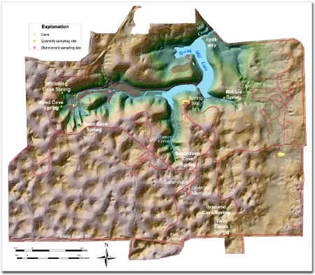
Shaded relief map of Spring Mill State Park drainage basin. Map
compiled by Chris Dintaman, Alex Zlotin, and Denver Harper. http://igs.indiana.edu/survey/projects/springmill/springMill01.cfm
Donaldson Cave system and Hamer Cave are the major caves in the
park, and both were intimately related to the life of the early
residents. Both provided water to power mills; saltpeter for
gunpowder was taken from Donaldson; and villagers butchered meat and
cooled perishable foods in both. Donaldson Cave is where the
northern blind cave fish was discovered, a now endangered species
that has no eyes. Donaldson Cave, dry side only, can be explored
without a guide but proper caving gear is recommended. All other
karst features within the park must must have a permit to be
explored. Applications for permits can be accessed at the park
office 8:30AM to 4:00PM daily (except Thanksgiving, Christmas, and
New Years days) or by calling 812-849-4129.

Twin Caves was named after two sink holes collapsed to expose this
cave in two places. The boat goes 500 feet into the cave then turns
around. Guided tours are available for Twin Caves.This is a 20
minute boat tour and is available weekends April to Memorial Day and
Labor Day to the end of October. Trips are daily from Memorial Day
weekend to Labor Day. Reservations can be made each morning, in
person, at the cave. Early arrival is recommended. Hours vary
according to season.
Photos of Donaldson Cave: http://wobey.net/TSG/Jerry/doncv/doncv.htm
In many karst areas, such as the "Sinkhole Plain" south of
Mammoth Cave, KY or any of the numerous other karst areas around the
country, I feel there is potential to find some impressive trees.
Even if the surrounding land had been cleared for farming or
timbered, often the bottom of the sinkholes are left untouched. They
are often protected by steep sides leading to the sinkhole bottom
and are left as inverted islands in altered landscapes. There is
potential for big trees that grew tall to compete with the trees
grown on the plain above, and potential for old trees left behind by
human activities. I remember driving across Kentucky and seeing
these pocket forests inside of the large sinkholes. (They are often
used as receptacles for trash and brush, but still are relatively
intact. Caves frequently lead off the bottoms of these large sinks.
Edward Frank
== 8 of 13 ==
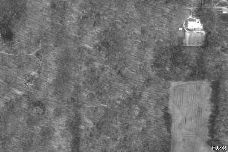
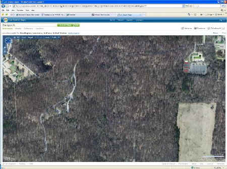
Date: Mon, Jun 2 2008 10:55 am
From:
Attached is a more detailed, color aerial photo from maps.live.com...
don't forget about that web site when scouting around...
PJ
== 9 of 13 ==
Date: Mon, Jun 2 2008 7:05 pm
From: "Gary A. Beluzo"
It's interesting that perhaps 95% of all limestone and dolomite is
biogenic. Without Life, Earth would still have the same atmospheric
composition as Venus and Mars (both are around 95-98% CO2 with
negligible N and O) however, about 3.5 billion years ago
photosynthetic bacteria began to use H2O as an electron donor and in
doing so initiated oxygenic photosynthesis with the removal of CO2.
Computer modeling demonstrates that if all the limestone/dolomite
were
to be converted back to CO2 our atmosphere would be no different
than
our two neighbors.
Gary Beluzo
== 10 of 13 ==
Date: Mon, Jun 2 2008 7:20 pm
From: Randy Brown
Also interesting is that this relatively abrupt oxygenation of the
ocean is the source of some of our largest iron ore deposits. So
called 'Banded Iron formations':
http://en.wikipedia.org/wiki/Banded_iron_formation
"It is assumed that initially the Earth started out with vast
amounts
of iron dissolved in the world's acidic seas. Eventually, as
photosynthetic organisms generated oxygen, the available iron in the
Earth's oceans was precipitated out as iron oxides."
== 2 of 3 ==
Date: Mon, Jun 2 2008 7:56 pm
From: Randy Brown
Ed,
Jeez, that's quite the geology lesson. I did go and visit hamer Cave
spring (the one that powered the grist mill) and Donaldson cave. It
was really impressive how much water was coming out of those caves
and
I can see why they built grist mills there. The south shore of lake
erie in Ohio has some karst area and volumous Springs (the blue hole
of castalia for example). One interesting factoid they pointed was
that the cave water is always ~50˚f, so it flows all year
round. In
the location in Ohio I read about it, everything else around froze
over so they had a bit of monopoly during the winter time. Mind you
this was in 1800's, when winter got quite a bit colder.
In reference to sink holes hiding big trees. Here's a picture of the
14'x150' footer, towering over everything else around it
==============================================================================
TOPIC: Donaldson's Woods Nature Preserve (Spring Mill State Park.
http://groups.google.com/group/entstrees/browse_thread/thread/4d50d2d099576b88?hl=en
==============================================================================
== 1 of 1 ==
Date: Tues, Jun 3 2008 10:21 pm
From: "Edward Frank"
Thanks Paul,
I do like http://maps.live.com
More often I use http://www.terraserverusa.com
both are worth checking out when scouting a location. I am pretty
heavy into using the internet to gather information on a site before
I visit or to help clarify things I have found otherwise. There are
tons of internet search engines out there Google, Yahoo, etc. I like
to use http://www.meatacrawler.com
which searches several different search engines for results. I find
it gives me a shorter list, but generally more useful results than
the other search engines. I have it set as my default search engine
in Windows Explorer (options in explorer explains how to change or
set your default search engine.)
Ed Frank
== 2 of 3 ==
Date: Wed, Jun 4 2008 6:51 am
From: "Susan Benoit"
Ed,
I absolutely agree with your choice for the best search engine, but
will note for the others (who might be confused by now) that it's http://www.metacrawler.com
, as is 'meta' (a typo, I'm sure.)
Sue
|


