|
==============================================================================
TOPIC: Raven Fork, GSMNP
http://groups.google.com/group/entstrees/browse_thread/thread/abdb09f2eee91a01?hl=en
==============================================================================
== 1 of 3 ==
Date: Wed, Oct 24 2007 4:48 pm
From: "Jess Riddle"

Ents,
Over 600 miles of trails crisscross Great Smoky Mountain National
Park's 520,000 acres, but only three-and-a-half miles of those
trails
and no roads traverse the approximately 14,000 acres of Raven Fork
watershed within the park. The paucity of trails along Raven Fork
does not reflect a lack of attractions: the basin's many ridges
above
5000' elevation provide extensive mountain vistas; coves in the
lower
half of the watershed support diverse assemblages of wildflowers;
old-growth stands of red spruce stand like dark green sentinels on
the
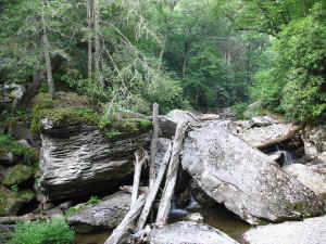
ridges and tower above the streams; and Raven Fork itself courses
dramatically down a boulder strewn channel. Instead, that lack of
development reflects the inherent difficulty of creating paths in
the
area. Timber companies attempted to access the basin's extensive
tracts of valuable spruce, but only had the resources to extend
their
rail line half way up the gorge through which Raven Fork now exits
the
park. Hence, no old road beds occur in Raven Fork, which often form
the foundation of hiking trails in the region. High rainfall, long
winters, and extensive tangles of rhododendron inhibit the
production
of more modest paths in the area.

The logging history, climate, and the abundance of rhododendron all
stem from the watershed's geology and topography. The erosion
resistant Anakeesta Formation underlies most of the watershed, and
Raven Fork flowing over it for eons has produced a dissected high
plateau stretching from the main crest of the Smokies south towards
the Cherokee Indian Reservation in North Carolina. As the stream
nears the park boarder, it encounters more erodable gneiss, and cuts
a
rugged gorge over 1000' deep. That gorge combined with the early
formation of the national park has allowed 97% of the original
forest
cover to remain, the most of any watershed in the park. Before
reaching the gorge, the stream flows for over eight miles and drains
a
broad plateau without dropping below 3800' elevation. The plateau's
high elevation ensures a cool climate and precipitation approaching
rainforest levels. Together with the strongly acidic bedrock, those
conditions create an ideal growing environment for red spruce,
yellow
birch, and rosebay rhododendron. No other area in the southern
Appalachians contains such an extensive, uncut forest dominated by
red
spruce. Below 5000', hemlock becomes increasingly common, and
exposed
sites often feature Catawba rhododendron also. Along small streams
enough nutrients accumulate that yellow buckeye can dominate small
patches of open understory forest within the sea of evergreens and
birch. Hardwoods also dominate many south facing coves in the lower
half of the watershed, especially where gneiss occurs close to the
surface. A mix of sugar maple, yellow buckeye, beech, yellow birch,
white basswood, and silverbell typically form the canopy over
mountain
maple, witch hobble, and a wide variety of herbs.
Ents have made only a handful of forays into the Raven Fork
watershed,
focusing primarily on areas around the periphery. Several years ago,
Will Blozan and Michael Davie ventured into Batsaw Branch, which
drains a conspicuously flat plateau on the southern end of the main
plateau, and found large diameter spruce and hemlocks but none of
unusual height. Across the gorge from Batsaw Branch, Ramp Cove
Branch
contains rich northern hardwood type forest, but no unusually large
trees. Higher in the watershed, Will made a more successful foray
into Thicket Branch, where a national co-champion red spruce
(12'2" x
146') and the North Carolina height record red spruce (152') were
found (the other co-champion red spruce also grows in the Raven Fork
watershed, but attempts to relocate the tree have been
unsuccessful).
A more recent trip into the Jones Creek Section of basin yielded for
more red spruce slightly over 140'. Thus, thousands of acres of
excellent habitat for red spruce, and possibly other species,
remains
unexplored.
Jess Riddle
== 2 of 3 ==
Date: Wed, Oct 24 2007 7:11 pm
From: dbhguru
Jess,
The ruggedness and remoteness of thousands of acres of the Great
Smokies defies what many people visualize as wilderness, believing
that you have to travel to the ends of the Earth before you can
experience real wilderness. To that I say balderdash. A few hundred
yards off a trail through one of the rhododendron hells and all
sounds of civilization are lost. the huge, towering trees, the luxuriant
understory, and the lack of signs of human presence make large areas
of the Smokies a real wilderness, albeit one stranded in a sea of
intruding humanity.
Bob
== 3 of 3 ==
Date: Wed, Oct 24 2007 9:38 pm
From: James Parton
Jess,
This is one area I would love to make a visit to. A forest of huge
red
spruce sounds like a paradise to me. This area will take some
planning
though. Thanks for the info.
James Parton.
|