|
==============================================================================
TOPIC: The Boogerman Pine (again) and McKee Branch, Cataloochee, NC-GRSM
http://groups.google.com/group/entstrees/browse_thread/thread/5e28e9ae6bc1def0?hl=en
==============================================================================
== 1 of 3 ==
Date: Mon, Mar 31 2008 8:10 pm
From: "Will Blozan"
ENTS, NPS,
I had the distinct honor to spend a day with the one-and-only super
ENT John
Eichholtz exploring some coves in Cataloochee on 3-27-2008. We were
blessed
with superb weather, and choose to explore some coves of McKee
Branch on the
southeast side of Caldwell Fork. The drainage lies in-between the
proven
super-tree areas of Sag Branch and Double Gap Branch. The topography
promised high potential for hemlocks and this was supported by
aerial
photographs of the area. Michael Davie has one report of the branch
from
2005 but as far as I know no ENT has done any extensive searching of
the
area.
http://www.nativetreesociety.org/fieldtrips/gsmnp/mckee_branch.htm
Since this was John's first visit to Cataloochee we just HAD to stop
by and
measure the Boogerman Pine. Kind of like Bob L. and "Jake"
I guess. As I
mentioned in my last post on "The Boog" I was not
confident I had the
highest top when I measured it from the east side. Shots from that
side
performed by myself and fellow "ENT" Darian Copiz have
been between 187.0
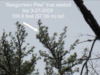
and 187.5 feet. There is a much more clear view of the top from the
south
but the base is all but hidden. John's sharp eye and laser probed
the top
cluster of nested foliage, and with me assisting at the base with a
20 foot
sighting pole we confirmed a solid shot of the "real" high
point; 188.8
feet! John was pleased at immediately raising the Rucker Index for
the
Smokies on the first tree he measured in Cataloochee!
Having thrown John a bone ;), we continued up the Caldwell Fork
Trail to the
McKee Branch Trail. I wanted to see this area for several reasons;
1) it
somehow slipped under the Tsuga Search Project "radar" and
2) I wanted to
scout the area for a potential "epic trip" event during
the ENTS meeting in
April. The PA "A Team" has expressed interest in exploring
the area and I
wanted to find a route in and out as well as get a preliminary taste
of the
area. I ended up getting a mouthful!
We ascended the McKee Branch Trail up the northeast side of the main
valley
to gain easy elevation. As Mike reported, the lower flats were cut
and
farmed but as we ascended we started to encounter some fine
old-growth
trees. To the east in drier coves oaks dominated with some nice
tuliptree
and cucumber magnolia. We lamented the falling of a huge chestnut
oak that
may have been 13'+ CBH X 140' tall. In northwest facing coves
tuliptrees
dominated with impressive, voluminous displays of the productivity
of the
soils. I had a rhododendron and hemlock cover map provided by the
NPS
(thanks Tom!) that turned out to have over-predicted both species
(thankfully with regard to rhodo!). We were quite pleased since
travel was
far easier than we expected, but some of the "old-growth
hemlock" forest was
actually young white pine. But that didn't matter so much- there was
plenty
of hemlock to see. Unfortunately, most were dead and the broad
overviews of
the valley below before we dropped in were devastating.
We reached a place on the trail where we decided to drop in to the
main
branch. The steep slopes of mountain laurel and rhododendron quickly
gave
way to open cove forests. American chestnut carcasses were common
and as a
result much of the forest was young in character. Some nice relic
chestnut
oak, cucumbertree, and spunky northern red oaks enticed us downward
to the
more gentle slopes. The first trees encountered were well-formed
specimens
of pignut hickory and cucumbertree. John measured the hickory to 8.3
ft CBH
X 132.1 ft tall, and seemed mighty impressed with the 12.4 ft CBH X
138.4 ft
cucumbertree. It was indeed a gorgeous tree! Large tulips and
emergent
hemlocks drew us across the main branch. Hemlocks were already in
the 150
class, and given our fairly high elevation that was a good sign. We
just
missed a ~17 ft red oak that fell over.
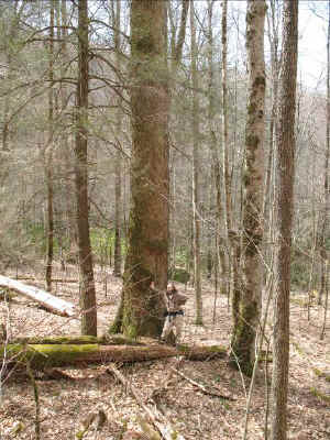
John and the big "cuke"
We decided to not follow a nasty, rhodo-choked narrow streamlet and
instead
wandered into a gorgeous "flat". HOLY MOLY! It was rich,
open and chock-full
of splendid sugar maple, red maple, hemlock, and tuliptree. A few
buckeyes
and basswood were present but not as common as in other rich pockets
of
Cataloochee. The first hemlock I measured was a forked whopper at
14.5 ft
CBH X 158.8' tall.

14.5 ft X 158.8 ft tall forked hemlock
Darn close to the Tsuga Search superlative threshold of 160'! John
measured
a nearby red maple to 8.8 ft CBH X 131.7 ft and a sugar maple at
10.2 ft CBH
X 128.7 ft. I continued upslope while John searched for higher tops
and
found another sugar maple 9.2 ft CBH X 128.5 ft tall. I let out a
yelp as I
found a very tall hemlock that roughed out to over 160'. He quickly
came up
to help with the laser shot. I zeroed the base as he shot the top-
14.3 ft
cbh X 165.1 ft tall!!!! What a huge tree, too! This brought the
number of
160 foot+ hemlocks documented by ENTS to 71. Definitely a 1000+
cuber.
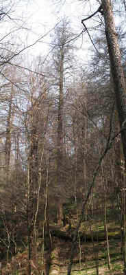
14.3 ft X 165.1 ft hemlock
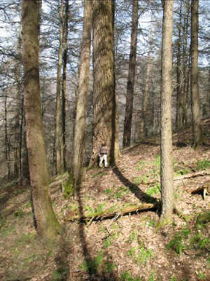
Not a bad start to the trip at all. Farther up the cove we spotted a
huge
tuliptree which blew John's mind at 18'2" X 160.1' tall. It
really didn't
look that tall because it was so chunky and stout.
The cove opened up even more into an awesome northern hardwoods
forest with
impressive groves of sugar maple. One nice bitternut was 7.2 ft CBH
X 138.6
ft. John measured a sugar maple to 9'11" X 131.9 ft- the
tallest of the day.
Old, craggy cucumbertrees were fairly common and hemlock was now
confined
only to steep draws incising the more open cove. Even though we were
close
to 4,000 feet in elevation the hemlocks were still right around 150'
tall.
Descending slowly, we crossed a small ridge and were greeted by
dense groves
of towering hemlocks. One tree growing at the base of a steep slope
and by a
spring proved to be our second hemlock over 160 ft. This tree was
smaller
than the first but still was a hefty specimen at 12.6 ft CBH X 161.0
ft tall
(no photo). John focused on a large black birch that proved to be
quite
tall- 9.0 ft CBH X 106.8 ft. He also measured a rare yellow birch
over 100
feet- a nice find at 6'5" CBH X 107.7 ft tall- one of the
tallest known!
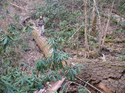
John crossing stream on huge fallen hemlock
A bit overwhelmed with the sheer number of hemlocks we got pulled
this way
and that and were torn as to which way to proceed. We left the cove
with the
12.6 ft X 161 ft hemlock and hovered on a small dividing ridge for a
bit so
as to peer in both directions. This allowed for the discovery of yet
another
giant hemlock. This one reminded me of the Yonaguska Hemlock in many
ways
("Yoni" was 14.45 ft cbh X 168.9 ft; 11th largest known
hemlock with 1324
cubes and 7th tallest), and it turns out to have nearly the same
conventional dimensions. This slow tapered tree split into two
bifurcations
at around 80 feet and the north one split again. A solid laser shot
confirmed the THIRD 160 footer for the day! It is also in the height
range
that could displace a climbed Tsuga Search finalist! The
"shortest" hemlock
in the project is 166.1 feet and this one calculated out to 14.4 ft
CBH X
166.7 feet. This whopper might reach 1,150 cubes.
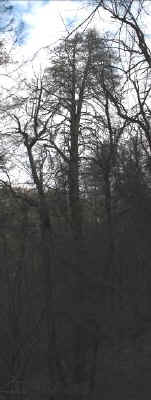
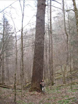
14.4 ft CBH X 166.7 ft hemlock with John at base
The day was quickly passing so we decided to leave the super hemlock
coves
and descend to the main branch and work our way to the trail.
Progress was
slow however, as more hemlocks appeared. Not far down from the last
tall one
I hit a 12.5 ft CBH X 157.7 ft hemlock in a flat by the stream.
Considering
the lack of immediate shelter this height was pretty good. Gnarly
tulips
became more common and one appeared to have more volume per
cumulative
length above the bifurcation than below. Weird tree.
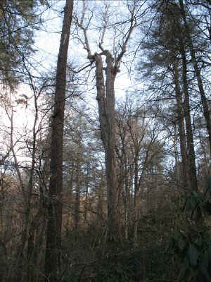
Oddly shaped tuliptree (Kind of like Gary Beluzo.;)
Next to this strange tuliptree came a double surprise. First, we
found the
first living, green hemlock on the branch and secondly, it was
ANOTHER 160+
footer! This tree was the smallest and perhaps youngest of the tall
ones so
far but it was still a lunker at 13.0 ft CBH X 162.1 ft tall. Not
200 yards
downstream was another massive hemlock spotted breaching a sea of
thick
rhododendron. I roughed it to near 160 feet from the comfort of the
open
ridge, but decided to wrestle my way to the base to spot the base
for John.
It was well worth it; 14.2 ft CBH X 160.2 ft. Yes, FIVE new hemlocks
over
160' in a matter of hours (with one still alive)! This last tree was
a hoss,
too; perhaps in the 1100 cube range. John and I were floored by the
production of this drainage.


Living 13.0 ft X 162.1 ft tall hemlock and nearby 14.2 ft X 160.2 ft
giant
We kept moving downstream following the path of least resistance.
Ahead, I
spotted what I thought might be a grove of some errant, emergent red
spruce.
The dark green conifers were quite tall but when we got closer I
realized
they were actually healthy-topped hemlocks! I am just not used to
seeing
that in Cataloochee. We went closer and one really stood out as a
giant.
Next to it was a beautifully reiterated beast. From our vantage
point
steeply upslope we could see how the trunk was a total shaft of slow
tapered
massiveness. The trunk even got larger in places high up the bole
and we
knew we had to nail down the height. It was a difficult one to
measure due
to the intervening vegetation but John finally found an opening and
I
spotted the base. Our vantage point on the steep slope made the tree
appear
taller than the lasered height of 151.3 feet but MAN! What a huge
tree! I am
seriously thinking of climbing this one as it could well be
significantly
over 1200 cubes. It reminds me very much of a slightly larger
diameter, but
shorter Tsuga Search tree that was right around 1300 cubes. Although
I
carried the reticle all day we did not have the time or good enough
visibility to estimate volume.

14.45 ft X 151.3 ft tall giant
John and I got back to the car at 7:45 pm, a grueling but incredibly
productive 10 hour day in Cataloochee. I hope he will post his
thoughts and
impressions of the day, Cataloochee, and the hemlocks. Fear not
Pennsylvania
"A Team" members, there is a LOT more to explore up there
including the
bases of some of the coves John and I surveyed higher up. If you're
up for
it, LET'S GO!!!
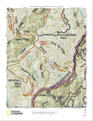
Location map of GPS plotted 160 footers found 3-27-2008
Will Blozan with John Eichholtz
3/27/2008
== 2 of 3 ==
Date: Mon, Mar 31 2008 9:06 pm
From: "Edward Frank"
Will,
Is there any plans to treat the living bug hemlocks you found? It
would be nice to keep at least on of the 160 footers alive.
Ed
== 3 of 3 ==
Date: Mon, Mar 31 2008 9:18 pm
From: James Parton
Will,
Cataloochee rules! I never tire of reading about your adventures
there. I am sure John was really impressed. I myself am overdue for
a
visit there. Now that my wedding is over and Joy is moved maybe I
can
find more time for exploration.
I bet Cataloochee is in order for the ENTS meeting.
James P.
== 3 of 8 ==
Date: Tues, Apr 1 2008 5:37 am
From: "Gary A. Beluzo"
Great post, Will. Are there any pine diseases (exotic or indigenous)
that threaten the pines in the Smokies, particularly in the
Cataloochie area?
Gary
== 4 of 8 ==
Date: Tues, Apr 1 2008 7:33 am
From: JamesRobertSmith
Wow! What an amazing hike! One of these days I hope to join you on
one
of those trips. I want to be able to find some of those superlative
groves.
== 5 of 8 ==
Date: Tues, Apr 1 2008 4:45 pm
From: Michael Davie
Great finds! That was next on my list to revisit- I went there in
November with someone who had an asthma attack and had to turn back,
and I've been unable to get back. When we went in, we came in from
Purchase Knob, I could see all of the dead hemlock crowns with big
tulips popping through. I'll be going back there soon. I knew it
would
be good.
Mike
== 6 of 8 ==
Date: Tues, Apr 1 2008 7:01 pm
From: "Dale Luthringer"
Geez, Will,
Do you think you guys could save any for the rest of us? This kind
of
thing always happens when Eicholz around. I think I'm starting to
see a
pattern emerging.
188.8' on the Boog'. amazing! That's ~10ft growth since the
hurricane
"re-shaped" it.
14.3' x 165' hemlock is absolutely incredible. Does the big stuff
ever
end down there?! Then followed up by a 14.4' x 166.7', then three
more
160's!!!
Enough! I can't take it anymore! Let me at em', let me at em'!!!
Dale
==============================================================================
TOPIC: The Boogerman Pine (again) and McKee Branch, Cataloochee, NC-GRSM
http://groups.google.com/group/entstrees/browse_thread/thread/5e28e9ae6bc1def0?hl=en
==============================================================================
== 1 of 5 ==
Date: Thurs, Apr 3 2008 3:12 pm
From: "Edward Frank"
Will,
The new top you found for the Boogerman is another leader on the
same upturned branch you have been measuring for the past several
years right? If you have been measuring the same lead, it would
still be worthwhile I think, when you visit the Boogerman to keep
track of how much the "former" high lead has grown as you
already have several years of data on its growth.
== 4 of 5 ==
Date: Thurs, Apr 3 2008 3:46 pm
From: "Will Blozan"
Absolutely. For the record, John found the top; I just suspected it.
I think
I have been measuring one of the "tops" to the right and
down of the arrows.
Will
== 2 of 5 ==
Date: Thurs, Apr 3 2008 3:30 pm
From: "Edward Frank"
Will,
You have measured the Boogerman many times. Have you ever compiled a
sequential listing of the height measurements of the tree?
Ed Frank
== 3 of 5 ==
Date: Thurs, Apr 3 2008 3:46 pm
From: "Will Blozan"
Ed,
No; it wouldn't amount to much before 2006 since my former laser
shot a yard
long. I could "back calculate" but my clinometer was a dud
as well. The
first laser shot after breakage was 180.1 ft, I believe.
Will
== 2 of 2 ==
Date: Thurs, Apr 3 2008 8:16 pm
From: John Eichholz
Ed,
If I am reading these pictures right, I would guess the top I
measured
was completely behind the one marked 187 feet on the left picture.
The
other three tops to the right I think are the same in each picture
but
from a different perspective clockwise around the tree.
For the record, the distances in the right picture, for successive
tops
from left to right are: 69.0y (tip of arrow), 67.5y (the
topmost-appearing top), 68.5y ("in the hole" between the
two more
prominent tops), and 67.5y. The tip of the arrow was 41.6 degrees
above
horizontal, the little tuft just below the arrowhead was 41.4
degrees,
and the topmost appearing top was 42.0 degrees. We could see the
left
(arrow) branch swaying independently of the middle (topmost
appearing)
branch in the wind. Remembering that the rangefinder is accurate to
only
0.5 yards, there is about a 2.5' difference between the 4 tops. At
least
the base offset was identical -- there is a thumbtack at 4.5' to
measure
off.
The base shot was 54.0y, -11.2 degrees to a spot on a pole 19.9 feet
above the base, for an overall height of 188.8'. Will measured the
circumference to 11.5'.
John
==============================================================================
TOPIC: The Boogerman Pine (again) and McKee Branch, Cataloochee, NC-GRSM
http://groups.google.com/group/entstrees/browse_thread/thread/5e28e9ae6bc1def0?hl=en
==============================================================================
== 1 of 5 ==
Date: Fri, Apr 4 2008 6:06 am
From: Larry
Will, John, Awesome Post! Great Photos. The trees up your way are
huge! Down here its rare to find such trees! Your reports are
excellent, I would enjoy going on an adventure with you. Larry
|