|
==============================================================================
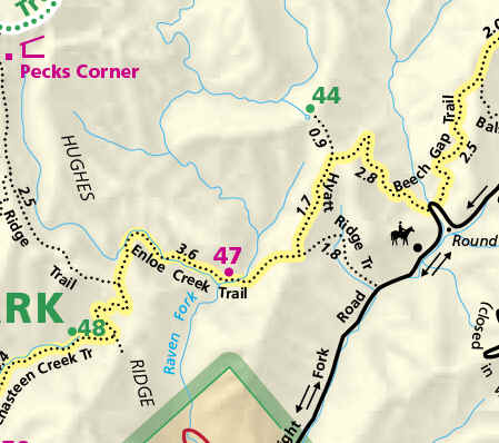
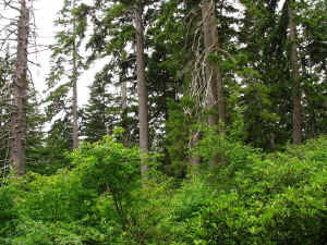
TOPIC: Simmons Branch and Hideaway Brook, Great Smoky Mountains NP
http://groups.google.com/group/entstrees/browse_thread/thread/deb32dd1a8044b51?hl=en
==============================================================================
== 1 of 1 ==
Date: Wed, Oct 24 2007 2:55 pm
From: Josh
July First,
Josh Kelly and I loaded up my car with gear eager to begin what
promised to be an adventurous two day backpacking trip. We were
heading off to the Raven Fork watershed on the Smokies' North
Carolina
side, and home to the largest known red spruce. The area's high
rainfall and extensive conifer dominated forest make Raven Fork the
closest thing to the Pacific Northwest in the southern Appalachians.
Adding to that resemblance, the watershed is untouched by logging,
one
contiguous block of around 14,000 acres of uncut forest, and remains
little explored. At the lower end, a single trail crosses the basin,
and other trails seem to keep their distance only following the
basin's edges. Maps still show a trail extending up Raven Fork
itself
and another trail used to complete the circuit around the watershed,
but the lush forests reclaimed those paths years ago.
After an hour and a half drive, we stopped briefly at the
Oconaluftee
Ranger Station to register for backcountry camping then continued on
to the Hyatt Ridge trailhead. A three foot diameter, conspicuously
robust sycamore stands by the trail's start, but the track quickly
climbs to slightly drier habitat with black oaks and mockernut
hickories. The trail follows Hyatt Creek through a narrow, southeast
facing valley, but keeps its distance from the stream. The path more
or less traces the interface between the dense woods dominated by
slender tuliptrees and scattered basswoods and the drier forest of
the
slopes. Eventually, the trail crosses Hyatt Creek then veers away
from the stream to ascend moderate slopes. Northern red oak and red
maples dominate the slopes and shallow coves, but give way to more
mesophytic tree species on fertile benches around 3800' elevation.
Vigorous second-growth stands of black cherry, black locust, sugar
maple, bitternut hickory, white basswood and white ash occupy the
moist gentle slopes that the trail skirts the upper edge of. At the
upper end of that moist forest, the trail passes through a gap
produced by a few overstory trees falling where phlox and purple
flowered raspberry were blooming amongst a thick growth of Allegheny
blackberry.
After 1.9 miles and climbing 1500' to 4400' elevation, we arrived at
a
gap on Hyatt Ridge and the start of the Enloe Creek trail. To the
right, the Hyatt Ridge Trail continues 2.5 miles along its namesake
to
the beautiful McGee Springs campsite. Ahead, the Enloe Creek Trail
drops 800' over the course of a mile down to Raven Fork. We
continued
straight and were struck by the immediate change in the forest; a
large yellow birch leaning over a spring and surrounded by large
northern red oaks announce that loggers did not reach the Raven Fork
side of Hyatt Ridge. The trail weaves down from the spring across
north and west facing slopes and coves. The richer slopes feature
beech and silverbell with a few large hophornbeams mixed in while
hemlock, birches, rhododendron, and one large black cherry dominate
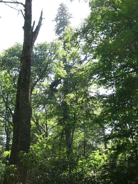
the more acidic slopes.
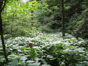
Josh in a sea of stinging nettle on the way back to
the trail. |
|
In between, stinging nettle carpets the coves
shaded by yellow birch, yellow buckeye, white basswood, and sugar
maple. Below the last cove, hemlocks extend down the slope from the
trail to Raven Fork, but the adelgid has reduced them to a shell of
their former selves. They cling to life with scattered grey needles,
but cannot persist much long. Underneath the hemlocks, rhododendron
screens the stream from the trail until the final switchback. Then
the scenery becomes much more uplifting with Raven Fork crashing
down
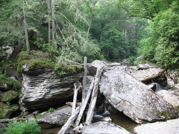
between moss and lichen covered boulders, many the size of a room.
At boulder top level, we crossed the stream on a sturdy, steel
bridge
to reach a small grassy campsite. Rhododendron sprawling down a
steep
slope and a large block of gneiss at the edge of a boulderfield
clearly demarcate the limits of backcountry campsite number 37,
which
is only large enough for one tent on either side of the trail. We
quickly set up our tent then, after a leisurely lunch, keyed out a
mint growing on the edge of the site.
With our energy restored and inspired by our surroundings, we set
off
on the Enloe Creek Trail again as it angled up a steep slope away
from
Raven Fork. The path winds under ancient, declining hemlocks and
wraps around steep, but broad, ridges to reach south facing slopes
above Enloe Creek. Those warmer slopes have less acidic soils, so
rhododendron does not thrive and exclude herbaceous plants.
Trailside
vegetation also differs in that stretch because still conspicuous
canopy gaps produced 11 years ago by Hurricane Opal create higher
light environments. Hence, goldenrods, white bee balm, green cone
flower, purple flowered raspberry, and a few turk's cap lilies crowd
the trail. As we traversed that section of trail, a large dark bird
circled overhead, which Josh was able to identify not as a raven but
as a golden eagle.
After about a third of a mile, we turned off the trail to start
climbing towards Simmons Branch, one of our two primary destinations
for the trip. Simmons Branch occupies a small area of striking
topography in lower Raven Fork. To the north and south, slopes drop
precipitously down to Raven Fork and Enloe Creek respectively, and
to
the west, the small peaks of Highland Ridge arise. In between,
Simmons
Branch drains a well defined plateau before plunging east into the
Raven Fork Gorge. On the plateau, the stream requires just less than
half a mile to drop from 4640' to 4440' elevation, but needs under a
quarter mile to fall the 600' elevation down to Raven Fork.

Raven Fork |
|
In most of the southern Appalachians, those elevations would be
too low to
support red spruce, except for sheltered north-facing drainages on
higher mountains, but spruce often grow at somewhat lower elevation
in
Raven Fork. Together the gentle topography, potential for warmer
than
normal growing conditions for spruce, and concentration exceptional
spruce known from the surrounding watershed made Simmons Branch an
enticing place to look for more exceptional large red spruce. The
unusual flatness of the terrain for a moderately high elevation site
made the drainage more intriguing as a potential site for rare plant
communities or species. Looking at aerial photographs confirmed an
abundance of conifers and suggested an access route that might
minimize the amount of rhododendron encountered; the coves between
Simmons Branch and Enloe creek showed as hardwood dominated with a
deciduous understory except at the very top.
As we ascended those coves from the trail, we found ourselves
hopping
from one gneiss boulder to the next under a canopy of hemlocks,
somewhat unusual for a boulderfield. However, continuing up the
overstory quickly transitioned to a more typical boulderfield mix of
yellow buckeye, white basswood, sugar maple and yellow birch with
scattered mountain maple underneath. Chickweed, stinging nettle,
yellow mandarin, blue cohosh, purple phacelia, and many other herbs
combined with thick layers of moss to make the boulders green. For
better footing and to avoid some of the nettle, we swerved out of
the
boulderfield and onto a low, steep ridge within the cove that has a
more beech dominated canopy. We eventually swung back into the
boulderfield when we started to see rhododendron on the small ridge,
but continued to make steady progress until we came to the conifer
dominated forest in the upper end of the cove. The edge of the
conifer forest, many eastern hemlock but also some red spruce,
coincides with the cove become much steeper and a dense understory
of
rosebay rhododendron. A few small cliffs that we had to detour
around
limited our route options, and blowdowns and dense patches of
blackberries added difficulty to the normal challenge of negotiating
rhododendron thickets. However, with a little scrambling we shortly
reached the edge of the Simmons Branch watershed.
Taking a break on the top of the ridge, we found ourselves in a
small
fragment of heath bald without a clear view into Simmons Branch.
Fires on exposed sites, at high elevations in the southern
Appalachians sometimes result in the formation of heath balds, dense
communities dominated by shrubs in the heath family. The density of
the shrubs' growth combines with the highly acidic, nutrient poor,
high aluminum soils to prevent tree regeneration within the bald,
and
allows the community to maintain itself for at least a few thousand
years. The evenness of the shrub canopy makes the areas look smooth
and leads to the alternative name 'slick'.
However, from the inside they look less slick and more like the
product of some very large, drunken spider working with wood instead
of silk. We weaved our way through the clumps of mountain laurel and
Catawba rhododendron down the ridge into a more typical forested
area
where rosebay rhododendron again became the most common heath. We
angled northwest off the ridge, across very shallow coves, and over
low ridges towards Simmons Branch itself. Rhododendron forms a
continuous understory regardless of topographic position underneath
a
canopy dominated by hemlock, yellow birch and smaller numbers of red
spruce and beech. Where beech bark disease has killed the beech,
blackberries also enter the understory. Areas on the south side of
Simmons Branch have gentle topography, but no bogs are present.
|
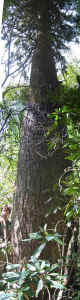
Potential national champion red spruce.
12'8"cbh and 146.7' tall.
|
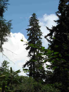
The top of the potential champion red spruce. Notice
that the tree gets plenty of sunlight, so it can grow
relatively quickly. |
Instead, trickles of water alternate with ten foot high ridges,
and on
one of those small ridges grows the largest red spruce we
encountered. The tree's upper half rises as a rich green cone in the
full sun above the surrounding birch. The tree's lower trunk rises
as
a flaky grey column out of the sea of rhododendron. Together, the
12'8" cbh trunk and 146.7' high crown give the tree enough
points to
qualify as a new national champion.
|
Stitch of potential national champion red spruce. 12'8"cbh
and 146.7' tall.
|
|
Going upstream, we passed by other large spruce as we waded through
the rhododendron sea, but none approached the size of the one we
just
measured. Eventually we came to a fork that did not appear on the
topo map, and a couple sugar maples at the fork, the first we had
seen
since entering Simmons Branch watershed, gave us hope of richer
forests and a reprieve from the rhododendron. Sugar maple, beech,
and
silverbell dominate the unmarked cove (you know you're in a wild
place
when whole coves are absent from the map), and provided us easy
passage out of the watershed.
The open understory conditions continued over a ridge into a small,
unnamed drainage that would provide us a route back to the Enloe
Creek
Trail. The stream generally maintains a low gradient, but the slopes
on either side are steep. Rosebay rhododendron covers all of the
slopes, but where we reached the stream, tall herbs, mostly green
cone
flower and bee balm, flourished in the riparian area. However, as we
descended along the stream, stinging nettle quickly took over the
herb
layer. These nettles were much more robust than the ones we
encountered on the in slightly drier settings on the way up to
Simmons
Branch. They grow leaf to leaf obscuring the ground and reach
shoulder height. Hence, to traverse the nettle stands, we felt our
way along with our feet hoping not to trip over rocks or logs, and
held our hands above our heads as if being arrested. The nettle
scoffed at our light weight, quick drying backpacking pants, so our
legs knew when we entered a nettle patch. Fortunately the nettle
stands are not very extensive; unfortunately, where the nettle ends,
the rhododendron thickets begin again. Where the rhododendron picks
up, red spruce also returns to canopy dominance. One tree right next
to the stream, an unusual topographic position for a large spruce in
the region, reaches 11'6" cbh by 139.0' tall.
|

Red Spruce 155' 3" tall, 10' 7" cbh
|
|
Within sight, another
spruce farther up a slope appeared to be worth measuring, so Josh
intrepidly hauled himself up through the rhododendron to the base
while I searched for a vantage point to measure the height. On a
10'7" cbh base, the spruce soars to a height of 155.3',
essentially
tying with a tree on the Tennessee side of the park as the tallest
known red spruce.
The rest of the way back to the trail was relatively uneventful.
Hemlock gradually replaced the spruce on the slopes, and yellow
buckeye and nettle took over the stream corridor. We receive a
little
help from a bear path through the nettle, the animals identity was
confirmed by a clear print in the stream sediment, but our legs were
glad when we finally reached the Enloe Creek Trail again.
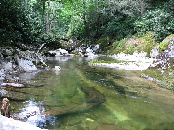
|
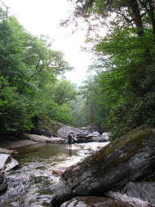
Fly fishing in Raven Fork
|
Pool in Raven Fork.
|
By the time we returned to camp, probably around seven, we felt
like
we had had a full day, but the clear pools and dramatic boulders of
Raven Fork were still alluring. Josh pulled out his fishing rod, and
I rock hopped up the stream looking for a rare lichen that had
recently been found a few miles upstream. Raven Fork received little
stocking of rainbow trout, and the gorge acts as barrier to upstream
migration of rainbow and brown trout. Hence, Raven Fork is the
largest remaining native brook trout stream in the southeast. Within
an hour, Josh caught seven brook trout, but none were large enough
to
keep. I didn't find the lichen looking for it, but stumbled across
the organism on a couple boulders on my way back to camp, as well as
a
host of other lichens. We had a quick supper and keyed out a couple
more plants before turning in for the night.
July Second,
While we slept, a mouse laughed at our food hanging system, scurried
down the steel cable past the spinning metal cylinders designed to
thwart it, and quickly gnawed a passage into Jess' food bag. We
broke
our fast under overcast skies and packed our remaining food - in
such
challenging terrain, it is a bit sobering to realize that one's
rations will be gone by the time the sun sets. After eating and
hanging our empty food bags, we set out up Enloe Creek Trail through
the beautiful northern hardwoods forest there. Our destination was
Hideaway Brook, which, like Simmons Branch, has unusually flat
topography in the headwaters of the stream. As we neared the
junction
of Enloe Creek and Hideaway Brook, red spruce and its ericaceous
companion plants became more common, and then formed a green wall on
steep slopes between the trail and Enloe Creek. We hiked past the
obvious confluence of the two streams, hoping for a section of open
understory to leave the trail, or at least some upright
Rhododendron,
but we found none, so dove down the slope into the only crawl-able
pitch of Rhodo we could find. After crawling and sliding down to
Enloe Creek, we had an easier time following that stream to the
mouth
of Hideaway Brook.
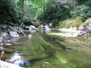
|

Hideaway Brook
|
Hideaway Brook
|
Hideaway Brook is an uncommonly beautiful stream, even for the
Smokies. On the overcast day we visited it, its water was even
clearer than the air, at least in my memory. On the lower reaches of
the stream, flowering herbs (including waist high stinging nettle)
and
hardwoods lined the stream corridor, while hemlock, rhodo, and some
spruce were more common higher up the slopes. The forest up to the
confluence of the two major forks of Hideaway Brook is fairly
typical
on Northern Hardwoods forest in the Southern Blue Ridge. Buckeyes,
beech and sugar maples were common in areas with deep soils, while
bouldery slopes were dominated by yellow birch with thick mats of
moss
and ferns covering the rocks.
|

14'5.5" cbh yellow birch.
|
|
One particularly noteworthy yellow
birch measured 14.6' in circumference - easily the fattest one I've
measured. We also stopped to measure a few red spruce, but none were
as large as those measured the preceding day; the largest being over
10' circumference and 130' tall.
I was most impressed with the Rich Montane Seeps (sensu Schafale and
Weakley) that were abundant along Hideaway Brook. Much like those
along the unnamed tributary of Enloe Creek where we found the height
co-champ spruce, many of these had impressive flowering displays
including bee balm (Monarda didyma), Clingman's hedge nettle (Stachys
clingmanii), green cone flower (Rudbeckia laciniata), jewel weed
(Impatiens pallida) and occasionally, small purple fringed orchid
(Platanthera psycoides). Some of the seeps were quite bog-like, and
even included mats of Sphagnum moss. There was also a robust sedge
that made a distinctive sound reminiscent of a broom on the floor
when
we walked through patches of it. Jess joked that if he ever figured
out which Carex it was, he would be able to identify it by nothing
more than the sound.
We chose to travel up the right fork of Hideaway Brook in a light
rain, and above that point, conditions for spruce improved. There
were many large, but no outstanding individuals by Smoky Mountain
standards. Trees reached up to 140' tall and 11' in circumference,
often in dense groves that are extremely picturesque. At around
4800'
elevation we crossed a spur of Katalsta Ridge to the left fork of
Hideaway Brook. There was a low gap in the ridge, but it was covered
in high rhododendron, which made for classic rhodo-surfing. At high
elevation, Rhododendron is often bent over from the weight of winter
snow-loads and grows parallel to the ground. These the most
difficult
conditions through which to travel through Rhodo. Jess and I spent
three solid minutes with our feet walking on nothing but rhodo
stems,
with the ground several feet below the stems we were walking over. I
slipped several times, only to have my feet land on a lower layer of
stems. This heath-bald-like forest allowed us to view the impressive
spruce forests on the slopes we were traversing, some with basal
areas
easily over 200 sq. ft/acre.
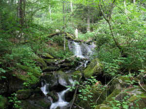
|

Red spruce forest. The trees in the center and on
the left edge are approximately 11' cbh.
|
Red Spruce Forests
|
Eventually, we reached the small tributary of Hideaway Brook, and
began crawling through the rhododendron that lined it. The rain had
stopped, but we were soaked to the core, so eventually resorted to
walking in the creek, which sped-up our return considerably.
|
Yellow birch with adventitious roots and epiphytic
rhododendron (Squid Tree)
|
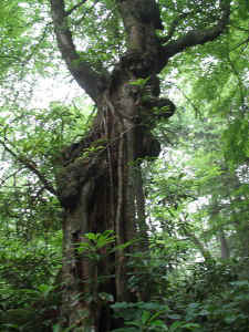
Different angle of the same tree.
|
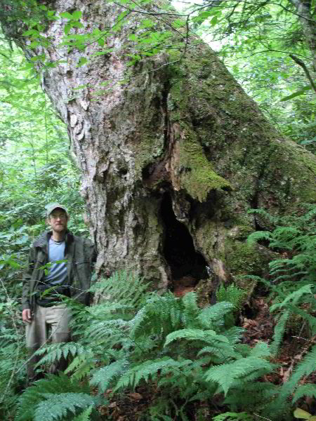
Just above the forks of the creek, we encountered one more tree
that caused
us to stop and gawk. It was a yellow birch over 11' in
circumference,
but was notable not for its size, but for the tentacle-like
adventitious roots it was sprouting that began far up the trunk. It
was loaded with epiphytic ferns, mosses, and lichens, and had a
spruce
seedling established in a crotch 15' up the trunk. After a few
photos
of this birch that reminded me of the rainforests
of Guyana, we continued our hasty retreat back to our campsite, and
our vehicle. This trip, though physically exhausting, only deepened
my thirst to explore Raven Fork further. I look forward to many more
outings there. In a sense, it is one of the more other-worldly
places
I've been in the Smokies. Its pristine nature, remote character, and
high elevations make it truly enchanting. The awe inspired by
exploring this landscape is indescribable - the mark of every
special
place.
Jess Riddle and Josh Kelly
|