fires in Georgia   Willard Fell
  Apr 22, 2007 20:33 PDT 
Perhaps off topic, but I just wanted to keep you posted with what is happening here in SE Georgia. This was our worst nightmare as forest land that historically has burned has developed tremendous fuel loadings as we have "protected it from fire" over the years. Now we are basically helpless to stop several massive fires that have developed over the past few weeks.

below are several links to video of these fires over the past few days.

http://www.firstcoastnews.com/news/topstories/news-article.aspx?storyid=80521

http://www.news4jax.com/news/12843529/detail.html

http://www.firstcoastnews.com/video/player.aspx?aid=97262&bw=

http://www.firstcoastnews.com/video/player.aspx?aid=97261&bw=

RE: more southeastern fire info   Willard Fell
  Apr 29, 2007 17:05 PDT 
 It started when a tree fell on a power line causing it to arc all along the road. It was during a extremely windy day following a strong cold front about 12 days ago and the 30-40 mile and hour winds quickly drove it to such a large size it was impossible to get ahead of it.

Southeastern Georgia Fires   Edward Frank
  May 01, 2007 15:46 PDT 

ENTS,

On NASA's Earth Observatory website are satellite photos of the fires taking
place in Southeastern Georgia. The most recent, posted today dates from
April 29:

Georgia Fires


http://earthobservatory.nasa.gov/Newsroom/NewImages/images.php3?img_id=17630

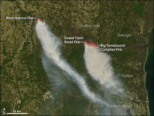
Several large fires were burning in southern Georgia on April 29, 2007, when the Moderate Resolution Imaging Spectroradiometer (MODIS) on NASA’s Terra satellite passed overhead and captured this image. Places where MODIS detected actively burning fires are outlined in red. The Roundabout Fire sprang up on April 27, according to the U.S. Southern Area Coordination Center, and was about 3,500 acres as of April 30. That fire was threatening homes in the community of Kirkland.

Meanwhile, south of Waycross, two large blazes were burning next to each other in the northern part of Okefenokee Swamp. The Sweat Farm Road Fire (previous images) threatened the town of Waycross in previous weeks, but at the end of April, activity had moved to the southeastern perimeter. The fire had affected more than 50,000 acres of timber (including pine tree plantations) and swamps. Scores of residences scattered throughout the rural area are threatened. The Big Turnaround Complex is burning to the east. The 26,000-acre fire was extremely active over the weekend, with flame lengths more than 60 feet (just over 18 meters) in places. The two blazes appeared to overlap in fire perimeter maps available from the U.S. Geospatial Multi-Agency Coordination Team.

According to the Southern Area Coordination Center morning report on April 30, the Sweat Farm Road Fire “will be a long term fire. Containment and control will depend on significant rainfall, due to the inaccessible swamp terrain.” No expected containment date was available for the Big Turnaround Complex Fire, either. Describing that fire, the report stated, “Heavy fuel loading, high fire danger, and difficulty of access continue to hamper suppression efforts.”

The large image provided above has a spatial resolution (level of detail) of 250 meters per pixel. The MODIS Rapid Response Team provides twice-daily images of the region in additional resolutions. They also provide a version of the image that shows smoke plumes stretching out across the Atlantic Ocean.

NASA image courtesy the MODIS Rapid Response Team, Goddard Space Flight Center


An earlier image from the 25th shows the Sweat Farm Road Fire:

http://earthobservatory.nasa.gov/NaturalHazards/natural_hazards_v2.php3?img_id=14230

Sweat Farm Road Fire, Georgia

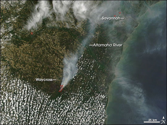
In southern Georgia, the Sweat Farm Road Fire, which began on April 16, continued to burn on April 25, 2007, when the Moderate Resolution Imaging Spectroradiometer (MODIS) on NASA’s Terra satellite passed overhead and captured this image.

During the early days of the fire, thousands of residents in and around the town of Waycross were evacuated because of the danger from the rapidly growing blaze. As of Thursday morning, April 26, the Southern Area Coordination Center reported that 58 residences and 30 commercial properties remained threatened. The fire was estimated to be 46,500 acres and about 50 percent contained. In addition to its threat to homes and businesses, the fire was endangering timber resources and wildlife habitat in parks, forests, and the Okefenokee Swamp.

The large image provided above has a spatial resolution (level of detail) of 250 meters per pixel. The MODIS Rapid Response Team provides twice-daily images of the region in additional resolutions.

NASA image courtesy the MODIS Rapid Response Team, Goddard Space Flight Center

Other Images for this Event
   
Posted: Apr 30, 2007
    Posted: Apr 20, 2007
    Posted: Apr 18, 2007


Ed Frank

RE: Southeastern Georgia Fires   Willard Fell
  May 01, 2007 19:13 PDT 
Thanks I hadn't seen those photos. If you go to the second image (4/29) and go to the larger resolution you can clearly see the brown/blackened area already burnt. The area outlined in red is just the actively burning head. The start of the Sweat Rd fire is approximately half way between the current heads of the Roundabout and Sweat Rd fire and at about the same latitude as the Roundabout fire. It currently is about 90,000 acres.

http://www.gfc.state.ga.us/

RE: Southeastern Georgia Fires   James Smith
  May 02, 2007 15:24 PDT 

We drove through south Georgia on our way back from the Keys. Even
though the fire was "70%" contained by that time, the smoke was truly
horrid. Visibility was quite low and we drove through the pall for many
miles--pretty much from the GA/FLA border and the next fifty miles.
BAck to Bob....wildfires   Willard Fell
  May 04, 2007 15:54 PDT 

You ask about regeneration. Probably won't be much Longleaf regeneration
as these fires are so hot they are killing everything. They are also
financially devastating to many of the forest landowners involved. Much
of the timber involves the life savings/retirement of these folks and
there will be no money for regeneration. Even Rayonier which has the
largest industrial stake in the area has lost close to 40,000 acres and
I understand the loss has affected their stock prices negatively. There
is no market in pulp for wood burnt as much as this and it is suspected
that less than 10 % will see any utilization as solid wood products
because of limited capacity, flooded markets and rapid degrade of the
round wood in the summer.

Here are some links for info and photos.

Latest Situation report
http://www.gfc.state.ga.us/GFCNews/WildfireSituationReport.cfm

Local Fire information page
http://www2.satilla.org/fireupdate/

fire photos (click on thumbnails)
http://www.gfc.state.ga.us/GeorgiaBayComplexPhotosJK/index.cfm

More fire photos
http://www.gfc.state.ga.us/GeorgiaBayComplexPhotos/index.cfm

Daily photos from area resident
http://new.photos.yahoo.com/warefire07/albums

Photos from the local hospital website
http://www2.satilla.org/fireupdate/photos/photos.asp

If anyone is interested in the minutiae of the operation, here is
today's action plan.

http://type2team.gfc.state.ga.us/CurrentStatus/IAP/iap.pdf


Willard H. Fell Jr.

District Forester
Georgia Forestry Commission
Altamaha Georgia Southern District

RE: Southeastern Georgia Fires   Will Fell
  May 08, 2007 15:24 PDT 

Thanks Ed; that is an interesting view I hadn't seen before. It is now threatening the town of Folkston about 40 miles SE of Waycross and has consumed about 160 sq miles. A new fire started by lightning is located in the swamp about 15 west of Folkston called the Bugaboo Scrub Fire and has burnt about 30,000 acres and is headed towards Lake City on I-10.
 
Florida has pulled all it's resources as it is starting to burn in Flagler and Lake Counties.

-----Original Message-----
From: Edward Frank 
Sent: Tue 5/8/2007 6:47 PM
To: Willard Fell
Subject: Georgia Fires


Will,

There is a new older image (April 19) of the Sweat Farm Road Fire on the EO -NASA website:

http://earthobservatory.nasa.gov/Newsroom/NewImages/images.php3?img_id=17635

Ed Frank
EO Newsroom: New Images - Bugaboo Fire Rages in Georgia and Florida   ed_f-@hotmail.com
  May 15, 2007 20:43 PDT 


New photos from May 11 of the fires in southern Georgia and Florida

The following link has been sent to you for your perusal:

http://earthobservatory.nasa.gov/Newsroom/NewImages/images.php3?img_id=17645