Don Bertolette (July 12, 2009) wrote:
Gary-
Having travelled for about 24 hours, then slept for 12, I'm
just now becoming aware of my surroundings in any meaningful
way (did find an excellent pub with nice array of taps
nearby!).
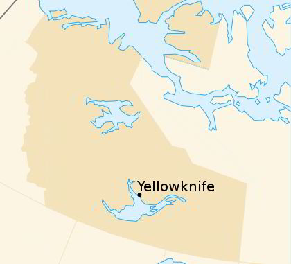
Northwest Territory (NWT), once larger is still sizable with
1,171,918 square kilometers (these numbers are large enough
to not be meaningful to most of us, but for US standards,
this would be 452,480 square miles). Its capital is
Yellowknife, an area once inhabited by the Dine (Athabascan)
although without permanence until gold was discovered some
75 years ago. Since then it has grown to I believe around
16,000 with a surprising vigor, numerous skyscrapers visible
on approach (from 7 to 12 story relatively new structures).
This year there are 600 plus more folks, with the arrival
of the International Congress of Circumpolar Health, for
which we are here (Rhonda is one of several keynote
speakers).
Back to limnology...the largest lake in NWT is the Great
Bear Lake (and fourth largest in the Americas, at 31,328
square kilometers, or 12,095 square miles) followed by Great
Slave Lake which graces Yellowknife with its wonderful
views, with 28,568 square kilometers (11,030 square miles).
The deepest lake in Canad, Great Slave Lake is 614 meters
deep (or 2,020 feet).
Not content with holding water, the Mackenzie River passes
through NWT on its way from Alberta to the Arctic Ocean and
at 1,800 kilometers (or 1060 miles) is the longest river in
Canada, the second longest river in North America, and the
third largest in the world. And one more superlative for
Bob's memory bank. Virginia Falls, at 90 meters (or 300
feet), is more than twice the height of Niagra Falls.
Okay, enough quantitative data you must be saying by
now...having gone to a showing last night, of a movie
documentary of water and its importance to the First Nation
(analogous to Native Alaskans, Native Americans). The purity
of water to those that live a subsistence lifestyle (we
would say, 'live off the land') is critical. Their water is
their life, as it brings the abundance that allows them to
live generation to generation.
That abundance is being threatened, upstream on the
MacKenzie River as it passes through Alberta's burgeoning
tar sands/oil production industry. The First Nation has
excellent leaders in their midst, a unity of the people and
growing power in the larger scheme of things, but as
everywhere, the industrial objectives have little concern
for the people, unless it affects their prodigious bottom
line. So the battle is set and goes on as we speak.
About the only other limnological item I can attest to is
from the approach to the airport and the drive to town.
Numerous small lakes abound in the area, it would seem as
the result of glacial scouring of the Canadian shield, which
makes itself apparent wherever not covered by what I'm
currently identifying as Black Spruce (65 mph assesment to
be verified later today). I can suggest that the balance of
bugs and fish in this area seem to be in balance...certainly
there's an abundance of black flies and mosquitos, although
not bad here in the city. Photos of 35 pound lake trout in
the local paper didn't seem out of the ordinary, perhaps as
a result of a catch and release regulation over a certain
size. I did meet two Texans at the brewpub that had been
fishing and said the largest catch of the day was a 50 plus
pounder. Just as well that they're released as 10 pounders
are preferred for eating...arctic char, usually smoked,
appear on many menus.
I'm attaching a few photos taken from near our hotel, of the
general countryside. I expect to gather more information and
will relay what I find in the disciplines of limnology and "limBology".
-Don
Don Bertolette (July 13, 2009) wrote:
WENTS/ENTS-
I’ve put together a slideshow of images, taken as I drove
from Yellowknife to the Cameron Falls trailhead, and then
along the trail to
the falls. My first time using Photobucket, I can’t promise
that I’ve done all
things correctly, but I hope so…it was a nice ride, hike and
I hope you enjoy
it (at least you’re able to enjoy it in a mosquito-free
environment! A
narrative follows the Photobucket link (where individual
slide titling and
descriptions can be found):
http://s875.photobucket.com/albums/ab312/forestoration/?albumview=slideshow
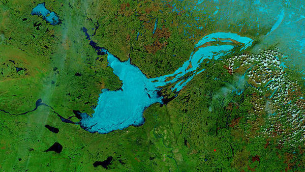
The community of Yellowknife is adjacent to Great Slave
Lake, and many smaller waterbodies. The
terrain is that of the Canadian Shield, an ancient exposed
bedrock that has
since the last ice age been partially covered with a Boreal
Forest Ecosystem. Numerous
bedrock exposures remain unforested. Where forested, stands
tend to be either
pure stands or depending on variable soil constituents,
mixed forest stands of
black spruce, white spruce, balsam fir, quaking aspen,
balsam poplar, or white
birch.
As a sample of the
countryside, I chose the Ingraham Trail which is paved at
first and later
graveled and a fine travelling surface.
Running east from the city of Yellowknife, the road
eventually parallels
the Cameron River for some 20 kilometers, passing by many
small to medium
lakes, some of which are populated with small summer homes,
some not. All are
quite scenic and retain much of their wilderness character.
Within the first few kilometers, the Ingraham Trail
crosses
the Yellowknife River with the appearance of being wide and
deep, with a fast
current. Looking up river, the forest
runs down right to the river’s edge, broken here only by a
summer cottage with
a small dock for small boat access.
Downriver, the Yellowknife runs into Great Slave Lake. The
roadway continues through the countryside
with roadside wildflowers brightening the otherwise green
forested expanses. Fireweed
and woodrose, familiar to Alaskans, grow along the roadway,
with an occasional
columbine.

Many of the lakes and marshes appear to seasonally and
annually adjust to differing water levels, while
the black spruce looks on...
The focus of the afternoon’s activity was to be a hike
out
to Cameron Falls, some 40 kilometers from town.
Parking at the trailhead, I met three hikers just coming out
of the
forest into the parking area, somewhat abruptly. We smiled,
we chatted briefly,
and off I went into the forest…it soon became clear why the
hikers had been in
such a rush. Swarmed by mosquitos, black flies, and an
incredibly aggressive
relative to what I’d call a deer fly (at least in
California), I could hardly
get my pack off, get it open, get out the hat/headnetting
I’d put there
thinking I might need it, and get it on…a
serious piece of equipment, it had thin bunji cords that you
put your arms
through to keep it close and tight to your shirt. Blessed
relief was had, after
a short killing spree of the few mosquitos that were caught
inside. Wearing
long pants and long sleeve shirt, I had only to sink my
hands deeply into my
pockets to attain fair protection from the flying beasts.
Even then, the longer
snouted ones were able to penetrate my shirt, when I wasn’t
in motion.
Ever walked over hill and dale, at a spirited pace, with
hands deep in your pockets? It took but
20 minutes to traverse a typically 30 minute hike. Was it
worth it? It was a
great trail, with sections of board
walk through marshy areas, and steps to negotiate steep
rocky sections. With
the crossing of each of two ridges, the sound of the falls
grew noticeably
louder. Each of the ridges tended to
have less soil coverage, and were characteristically bedrock
with depressions
pocketing sufficient soil to have “islands” of mosses,
forbs, grasses, wildflowers
and/or small jack pines, white birches, or quaking aspens.
When I say
sufficient soil, I am describing shallow (perhaps several
inches thick) and small
(sometimes as little as a meter square) patches in small
rock basins. Sometimes
it takes nothing more than a crack in the bedrock for jack
pines (Pinus banksiana
lamb.) or birches

Would Bob be offended if I named this tenacious southern
dweller the Bob Leverett tree?
Okay, I admit it, this was my favorite tree of the hike, at
my favorite location overlooking the
Cameron River as it exits Cameron Falls! It has two criteria
that I am beginning to recognize as
critical characteristics for the really old
old-growth...one, the ability to live economically and two,
the ability to face adversity and prosper...(I know, it's
not a long lived species, but hey, I'd be
smiling if this were my next life!
and aspen to take up residence. The forest
across much of the trail consisted of primarily white birch
and black spruce of
small dimension due to the limited soil availability. These
boreal species
range across much of the Canadian provinces. Jack pines, a
close relative to
the lodgepole pine (they hybridize) share an interface that
approximately
splits Canada east/west. Jack pines will range just a little
bit higher before
giving way to a purer black spruce/white birch community.
Like the lodgepole, jack pines have
attenuated cones that expose their fire-adapted ecology,
persisting through
many years, and opening primarily in response to the heat
from wildfires.
It is said that indigenous natives have been
known to parboil male flower cluster to remove resins, to
make them a desired
food item.
I was finally myself not considered as a food item for
the
swarming hordes, when I at last arrived at the Cameron
waterfall. There the air
was displaced by the cascading falls (some 15 meters in
height) into enough
wind currents that the viewpoint was bug-free and the hat/headnet
was
greatfully remove. And a gorgeous
waterfall it is. Loud, chaotic, braiding, it looks
impassable by even the most
serious watercraft (which do ply upper and lower Cameron
river waters).
After a satisfying respite, the netting went back on,
hands
once again sought the depths of my pockets, and I returned
in a fashion similar
to my initial entry. At the trailhead once again, I met a
young couple in
tanktops and shorts, bade them good luck, and returned to my
transport…another
brief battle ensued extinguishing the mosquitos attached to
me, before driving
off. No better recommendation I can make than that made by
the Boy Scouts…”be
prepared!”, and a good time can be had by all.
-Don